


Abstract
Alejandro Sánchez de Miguel and colleagues describe a short-cut to make the most of a wonderful scientific resource.
Astronauts have been taking photos of Earth for decades (Pettit 2008), but the past few years have seen a dramatic increase in the quality of the imagery, particularly at night. Night-time images often have a large public resonance, perhaps because artificial light is such a unique signature of human activity on Earth (figure 1). While these beautiful pictures are freely available from NASA (The Gateway to Astronaut Photography of Earth, http://eol.jsc.nasa.gov), the sheer number of photos can make finding, for example, an image of a particular city at night a challenge. It can be time-consuming to find the original data for an image perhaps popularized by an astronaut through Twitter.
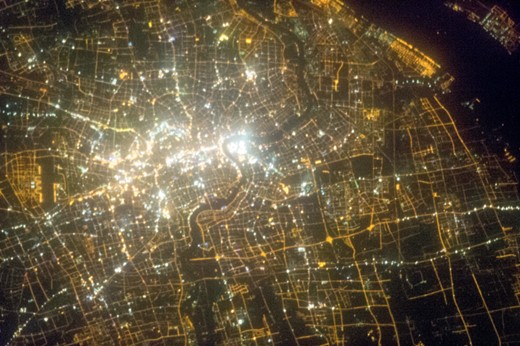
Shanghai city centre from the ISS. (Image ISS034-E-38784, from The Gateway to Astronaut Photography of Earth)
Illumination observed at night comes primarily from outdoor area lighting such as street lighting (Kuechly et al. 2012) and architectural lighting. Astronaut photographs have several advantages over satellite observations from sensors such as DMSP/OLS or the new VIIRS Day Night Band (see Miller et al. 2013). They offer far better spatial resolution (better than 10 m compared to 750 m), three spectral bands in the visible range (compared to one which includes sensitivity to some infrared but not blue light), and variable overpass times (as opposed to fixed). If the thousands of images were more easily accessible, they would be of great use in disparate fields including human geography, ecology and conservation biology, energy and carbon analysis and policy, public safety, epidemiology of light-at-night mediated disease, and our personal research topic: improving understanding of light pollution.
To facilitate our own research (Zamorano et al. 2011), over the past three years we have put together an atlas of astronaut images of the Earth at night. The atlas was compiled manually by inspecting more than 300 000 images from The Gateway to Astronaut Photography of Earth, and comparing selected images to DMSP/OLS data and online maps (Google Maps, OpenStreetMaps, etc). Our atlas has 1695 night-time images of known cities. Besides making finding images of particular cities easier, the atlas includes additional information not available in the NASA gateway, for example the image ISO and exposure time. The atlas has now developed to the point where we feel it can be of use to other researchers, as well as to journalists, policy makers and interested citizens.
Web access
We have developed a web portal to allow easy access to the images (http://www.citiesatnight.org). It contains a map of the Earth, with dots showing cities for which we have a tagged photograph. Clicking on a dot brings up detailed information about the photograph, including a thumbnail and a link to the original raw image at the NASA website. The atlas also provides a link to an interactive table that allows the user to apply filters to find relevant images (e.g. searching for a specific city, latitude and longitude, or time of night). We hope that making such images more widely available will lead to better understanding and conservation of the Earth's night.
These pictures were made possible because of public funding for space exploration. Moving forward, we intend to use these images to involve the public more directly in research. In addition to the atlas, we have developed an online portal to allow citizen scientists to help classify all of the night-time images taken from the ISS. Our initial atlas contains photographs from hundreds of cities worldwide, but we know that there are many more images still hidden in the dark of the repository. The astronauts also continue to take new photographs that need classification. As well as helping improve our understanding of Earth, we hope that participation in this project will be rewarding to the participants (e.g. pride at finding and publicizing an image of their hometown). We have also developed a tool that allows citizen scientists to apply their lay knowledge, by georeferencing images using maps of the cities that they are familiar with.
Our motivation for working on characterization of the images was to make use of them as a scientific tool. But we hope that our atlas will be an example of the achievements that are possible when we work together, and a demonstration of the value that open-data policies provide to the citizens of Earth. We invite you to visit http://www.citiesatnight.org to browse images or to become a contributor.
We want to thank the astronauts who took the pictures, in particular astronauts Sochi, Hadfield, Kupiers, Pettit and Parmitano. We also acknowledge the international cooperation that makes the ISS and this research possible.
