Mapping Dragon Fruit Croplands from Space Using Remote Sensing of Artificial Light at Night


1
College of Forestry, Beijing Forestry University, Beijing 100083, China
2
Institute of Geographic Sciences and Natural Resources Research, Chinese Academy of Sciences, Beijing 100101, China
3
Department of Geography and the Environment, University of North Texas, Denton, TX 76203, USA
*
Author to whom correspondence should be addressed.
Remote Sens. 2020, 12(24), 4139; https://doi.org/10.3390/rs12244139
Submission received: 28 October 2020
/
Revised: 14 December 2020
/
Accepted: 16 December 2020
/
Published: 17 December 2020
(This article belongs to the Special Issue Advances of Remote Sensing in Environmental Geoscience)
Abstract
:The nighttime light (NTL) on the surface of Earth is an important indicator for the human transformation of the world. NTL remotely sensed data have been widely used in urban development, population estimation, economic activity, resource development and other fields. With the increasing use of artificial lighting technology in agriculture, it has become possible to use NTL remote sensing data for monitoring agricultural activities. In this study, National Polar Partnership (NPP)-Visible Infrared Imaging Radiometer Suite (VIIRS) NTL remote sensing data were used to observe the seasonal variation of artificial lighting in dragon fruit cropland in Binh Thuan Province, Vietnam. Compared with the statistics of planted area, area having products and production of dragon fruit by district in the Statistical Yearbook of Binh Thuan Province 2018, values of the mean and standard deviation of NTL brightness have significant positive correlations with the statistical data. The results suggest that the NTL remotely sensed data could be used to reveal some agricultural productive activities such as dragon fruits production accurately by monitoring the seasonal artificial lighting. This research demonstrates the application potential of NTL remotely sensed data in agriculture.
1. Introduction
Artificial nighttime lights present one of humanity’s unique footprints that can be seen from space [1]. When the sun sinks below the horizon, the surface of the Earth will be lighted by shining cities, spotting villages, fishing boats, gas flaring, forest fires and other human activities. These lights can be captured by visible and infrared sensors in space. Unlike daytime remote sensing, nighttime remote sensing has the distinctive capability to reflect human activities [2], and therefore has been widely used in social and economic studies [3]. The nighttime light (NTL) on the surface of the Earth is a great indicator of the changes made by humans, which can also be shown as snapshots of human activities in both time and space [4].
From global to local scales, NTL data have been extensively used in urban mapping and urbanization studies [5]. NTL data can clearly reflect the development [6], utilization [7] and structure [8] of urban areas. Time-series NTL data have been used to describe the process of urbanization [9], present the urban expansion [10], sketch the contours of structural changes [11] and help reveal the internal driving force of urban development [12]. As an indicator of human activities in spatial and temporal dimensions, NTL data have been used along with other data such as population [13], gross domestic product (GDP) [14], energy consumption [15] and other socioeconomic data [16]. In addition, NTL data have been successfully used to monitor the conflict areas in Iraq and Syria [17,18], disaster assessments of earthquake [19], hurricane damages [20] and forest fire losses [21], among others. NTL data can also reflect the development of resources to a certain extent. NTL data have been used to trace and estimate fishing activities on the sea at night [22,23]. Gas flaring observed by nighttime remote sensing has been used to detect platform positions, evaluate the production capacity and to estimate the environmental impact [24,25]. Coupled with ecological, environmental and public health data, NTL data have been used to assess air pollutants [26] and light pollution [27] at night. Discussions on some developments and challenges in nighttime light observation can be found in [3].
As can be seen from the literature mentioned above, a common practice for NTL data application is to establish correlations between NTL images and human activity indicators such as GDP, urban built-up area and power consumption. Traditionally, NTL images are not used in agriculture due to the lack of observable night light in agricultural fields. With the development of light agriculture technology, more and more croplands, especially fruit fields, are using supplemental lighting technology to deal with the lack of sunlight in the short-day season, so as to extend the flowering period and increase yield. For example, the lighting facilities used in dragon fruit fields in Taiwan, Vietnam, the Philippines, Sri Lanka and other Southeast Asian regions can significantly extend the flowering period and increase the production of dragon fruit [28]. The widespread application of the field light agricultural technology makes it possible for agricultural monitoring using NTL remote sensing.
Unlike urban lighting, agricultural lighting exhibits characteristics of a seasonal cycle due to the difference in demand for lighting—the shorter the duration of sunshine, the higher the demand for artificial lighting. Therefore, NTL remotely sensed data, such as the monthly composite data of National Polar Partnership (NPP)-Visible Infrared Imaging Radiometer Suite (VIIRS), could well reflect the seasonal changes of artificial lighting. As an initial exploration of NTL remotely sensed data for crop monitoring, this paper presents the application of NTL monthly composite data from NPP-VIIRS for monitoring seasonal lighting variations of dragon fruit croplands in Binh Thuan Province, Vietnam.
2. Materials and Methods
2.1. Study Area
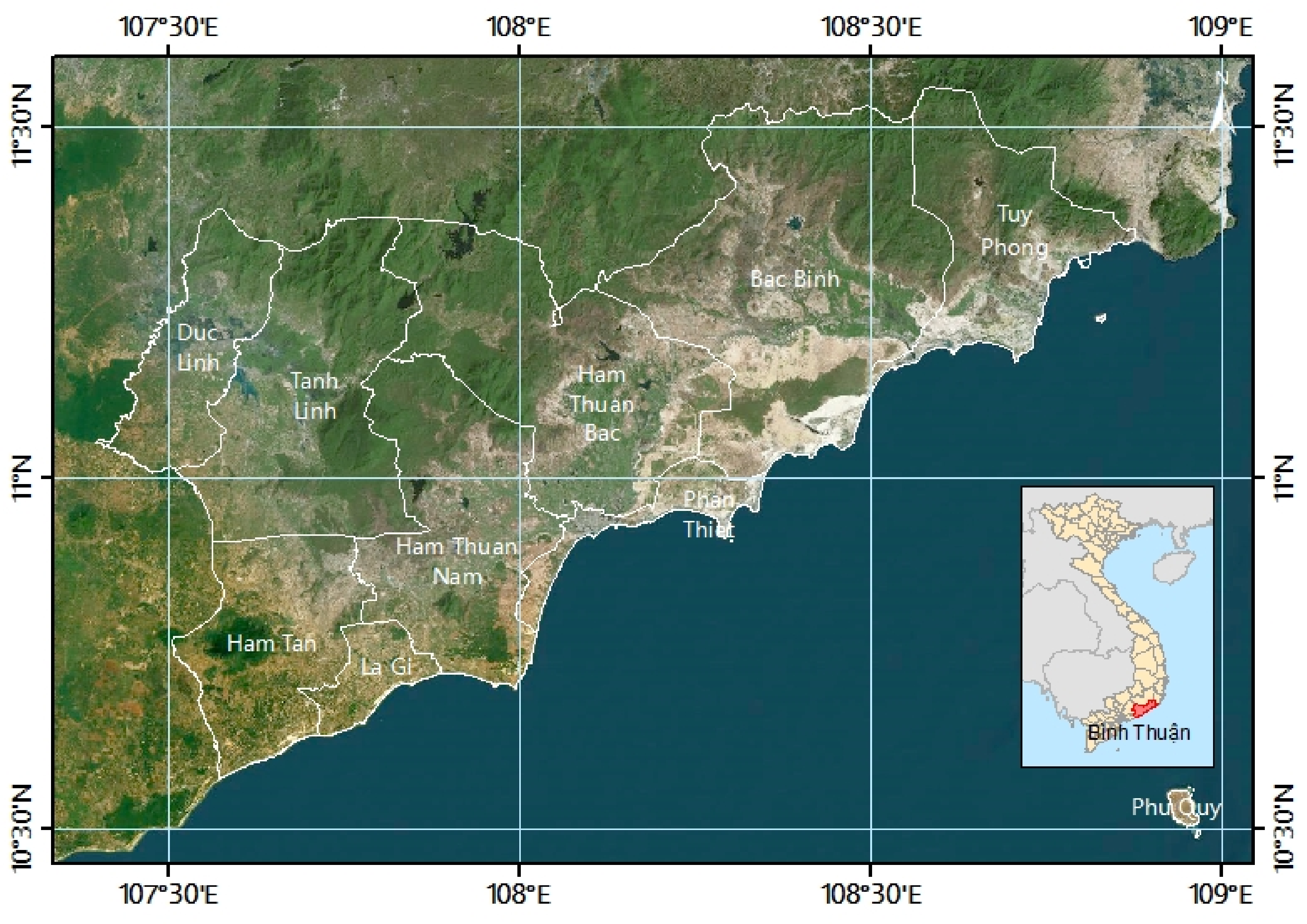
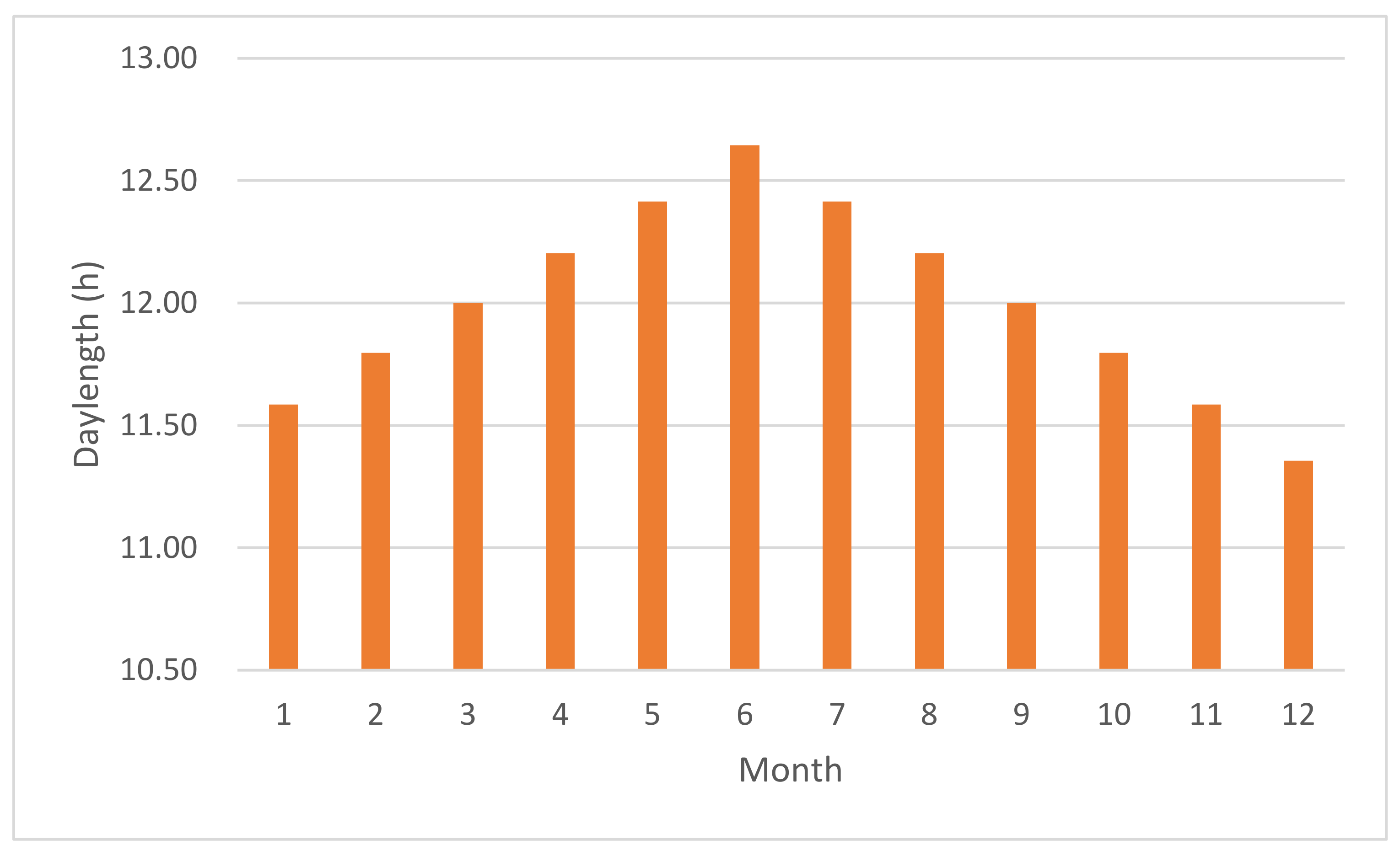
The province of Binh Thuan in Vietnam was selected as the study area. Binh Thuan Province of Vietnam is located at 10°33′42′′ to 11°33′18′′N, and 107°23′41′′ to 108°52′18′′E, covering an area of 7792 km2 (Figure 1). It is situated in a climate zone divided into two seasons—the rainy season from May to October and the dry season from November to April [29]. The monthly day length in a year is between 11.36 and 12.64 h, with the longest length in June and the shortest in December (Figure 2). Binh Thuan is subdivided into 10 district-level subdivisions, including one provincial city: Phan Thiet (capital of Binh Thuan province), eight districts: Bac Binh, Duc Linh, Ham Thuan Bac, Ham Thuan Nam, Ham Tan, Phu Quy, Tanh Linh and Tuy Phong and one district-level town: La Gi [30].
Dragon fruit is one of the easiest fruits to grow. Being a member of the cactus family, it prefers a dry warm environment and does not need much care when it is settled. Dragon fruit usually needs over a 12 h day length environment for blossoming and bearing fruits. The warm and rainy climate in Bình Thuan is particularly suitable for the cultivation of dragon fruit, making Bình Thuan the largest producer of dragon fruit in Vietnam. The dragon fruit planting areas in Bình Thuan account for two-thirds of the total planting area in Vietnam. In 2014–2018, the planted area, area having products and production of dragon fruit in Bình Thuan Province were increasing year by year [31].
In order to maintain production throughout the year, Vietnamese farmers have developed a lighting technique used at night for dragon fruit croplands in the off-season. Depending on the season, the time for lighting (such as the number of nights, and the number of hours per night) changes accordingly so that the dragon fruit tree can flower [32]. The flowering can be induced by breaking the dark period with artificial lighting between 10:00 p.m. and 2:00 a.m., allowing the off-season production from November to April [33].
2.2. NTL Remote Sensing Dataset
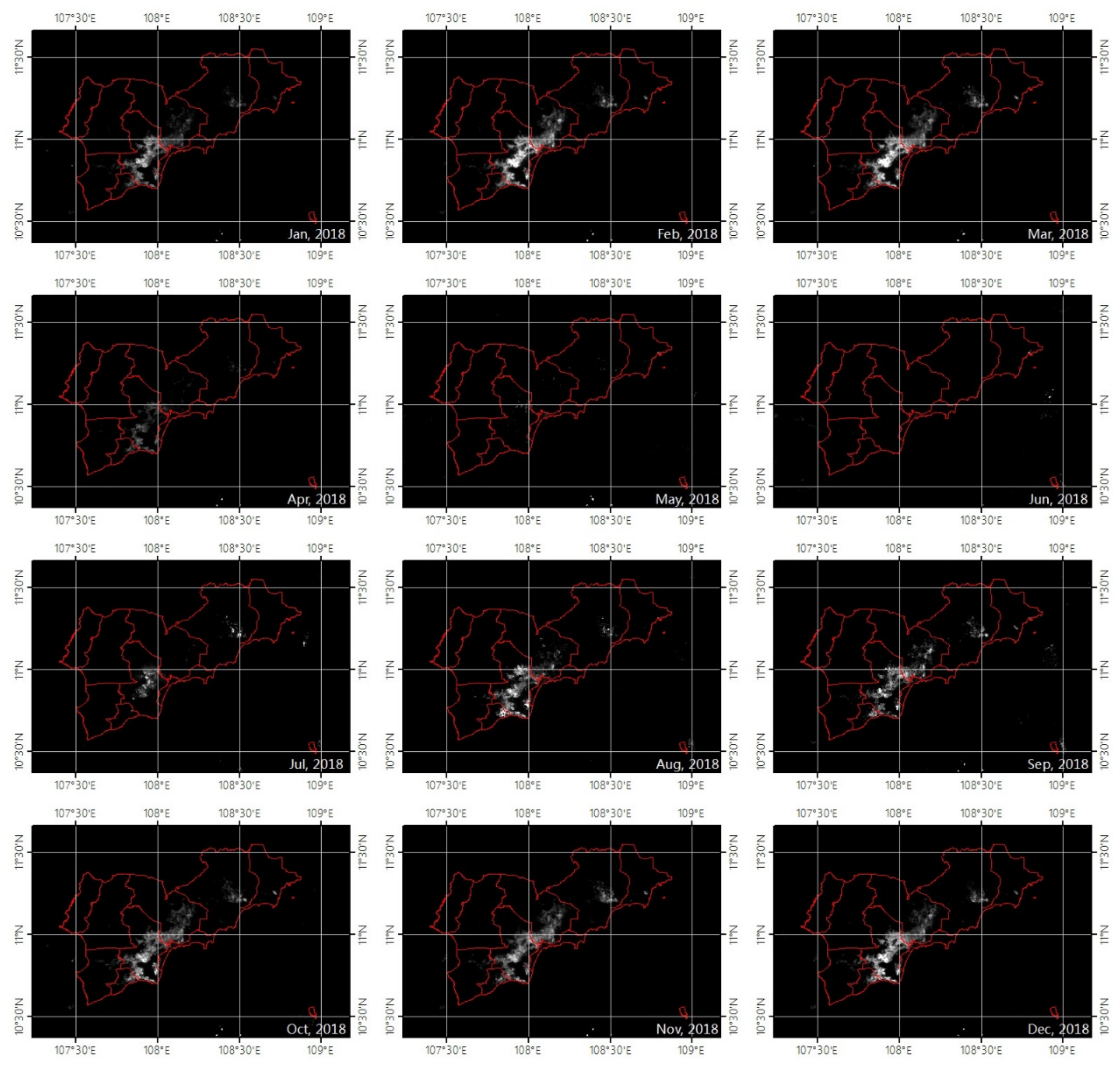
The major NTL datasets for free use include the Defense Meteorological Satellite Program (DMSP) Operational Linescan System (OLS) from the USA, Visible Infrared Imaging Radiometer Suite (VIIRS) instrument onboard the Suomi National Polar Partnership (NPP) satellite from the USA and nighttime photographs taken by astronauts on the International Space Station (ISS) [34]. In this study, NPP-VIIRS NTL monthly composite data covering the Binh Thuan Province of Vietnam from January to December 2018 were used (Figure 3). These datasets were provided by the Earth Observation Group, Payne Institute for Public Policy (https://eogdata.mines.edu/download_dnb_composites.html). The NTL monthly composite data were produced by averaging daily day/night band (DNB) data, which was filtered to exclude data affected by stray light, lightning, lunar illumination and cloud-cover. The unit of NTL monthly composite data is nanowatts/cm2/sr. With its 1:30 a.m. local time nighttime overpass [35,36], VIIRS can capture the lighting from the dragon fruit croplands in the study area, along with 15 arc-second geographic grids (about 450 m per pixel in the study area) through DNB and composited monthly [2].
2.3. Official Statistics
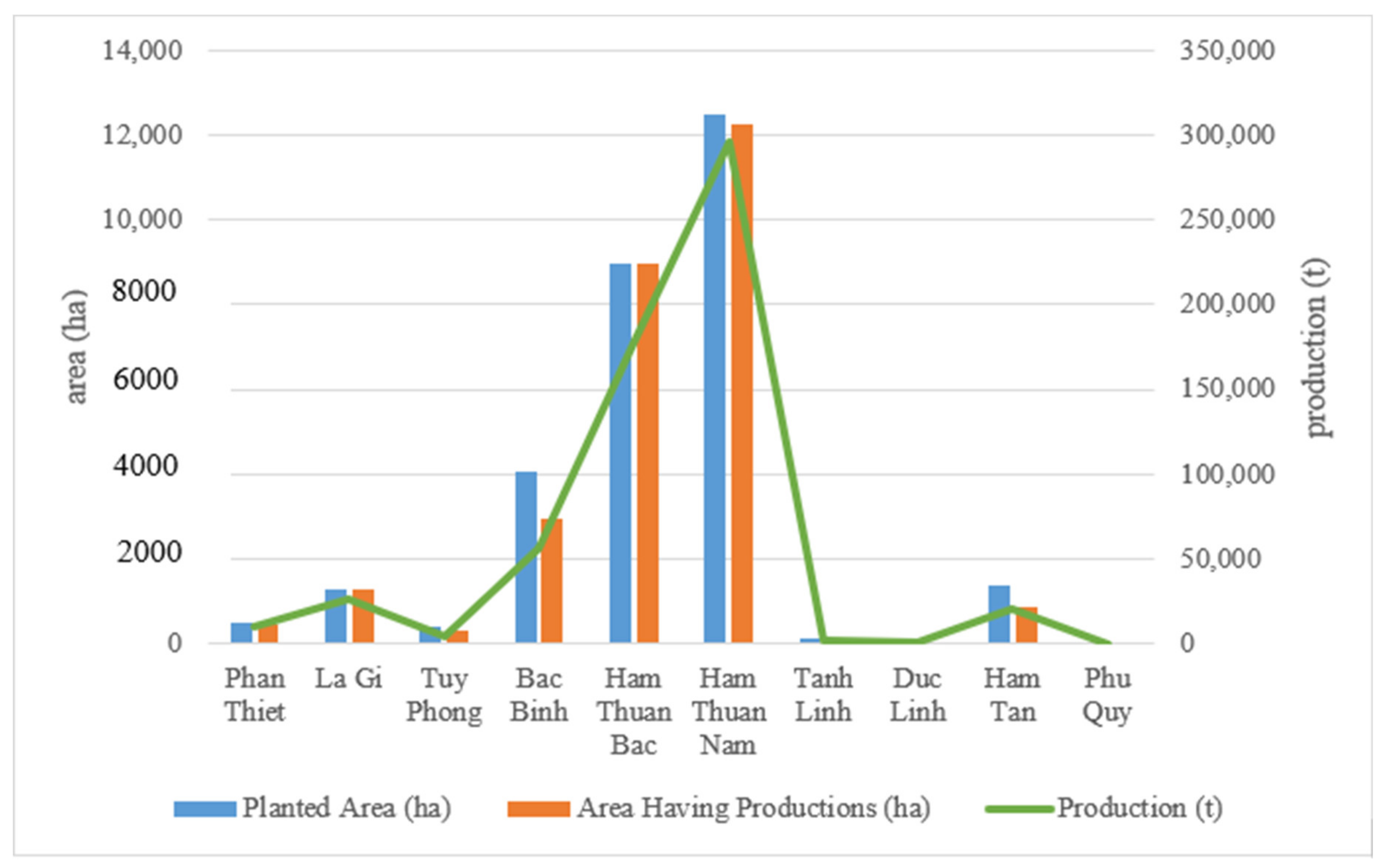
The statistical data in this paper were acquired from the Statistical Yearbook of Binh Thuan 2018 released by Binh Thuan Statistical Office in July 2019. The data for dragon fruit such as planted area, area having products and production from each county of Binh Thuan Province in 2018 were obtained for describing the agriculture activities, which may be associated with artificial lighting [37]. Due to the limitation of terrain and climate, the distribution of dragon fruit plantations in Binh Thuan Province is uneven. Statistics of the planted area, area having products and production of dragon fruit in the statistical yearbook show that dragon fruit croplands are mainly distributed in the three counties of Ham Thuan Nam, Ham Thuan Bac and Bac Binh, while very few in other subadministrative regions (Figure 4).
2.4. Spatial Distribution of NTL Brightness
In this study, the spatial distribution of NTL brightness was expressed by the mean value of annual DNB, that is, the mean value of the monthly composite DNB value of the NPP-VIIRS in Binh Thuan Province from January to December 2018. The calculation formula is as follows:
where i stands for the order of months, stands for the monthly composite DNB value located in a pixel and is the mean value.
In order to facilitate the comparison of local statistical data, it is necessary to calculate the total annual mean brightness based on each pixel of throughout the administrative area specified in the statistical yearbook. The sum value of (SUM of MEAN) for each subdivision of Binh Thuan Province is calculated by the tool of “Zonal Statistics” in ArcGIS with the parameter of “Statistics type” set as “SUM”.
2.5. Temporal Series Changes of NTL Brightness
The temporal series change characteristics of NTL brightness was illustrated by the standard deviation value of annual DNB, that is, the standard deviation of the monthly composite DNB value of the NPP-VIIRS in Binh Thuan Province from January to December 2018. The calculation formula is as follows:
where i stands for the order of months, stands for the monthly composite DNB value located in a pixel and is the standard deviation. Similar to in 2.4, the sum value of (SUM of STD) for each subdivision of Binh Thuan Province was calculated by the tool of “Zonal Statistics” in ArcGIS with the parameter of “Statistics type” set as “SUM”.
2.6. Relationship Analysis between NTL Brightness and Statistical Data
The relationships between the total annual mean light brightness (sum of he mean) and standard deviation of the annual light brightness (sum of STD) in the administrative area and the statistical data such as the planting area, harvested area and output of the dragon fruit in the corresponding administrative area were analyzed by correlation, and the capability of NTL remote sensing in artificial lighting agriculture was analyzed.
3. Results and Analyses
3.1. Spatial and Temporal Change Distribution of NTL Brightness
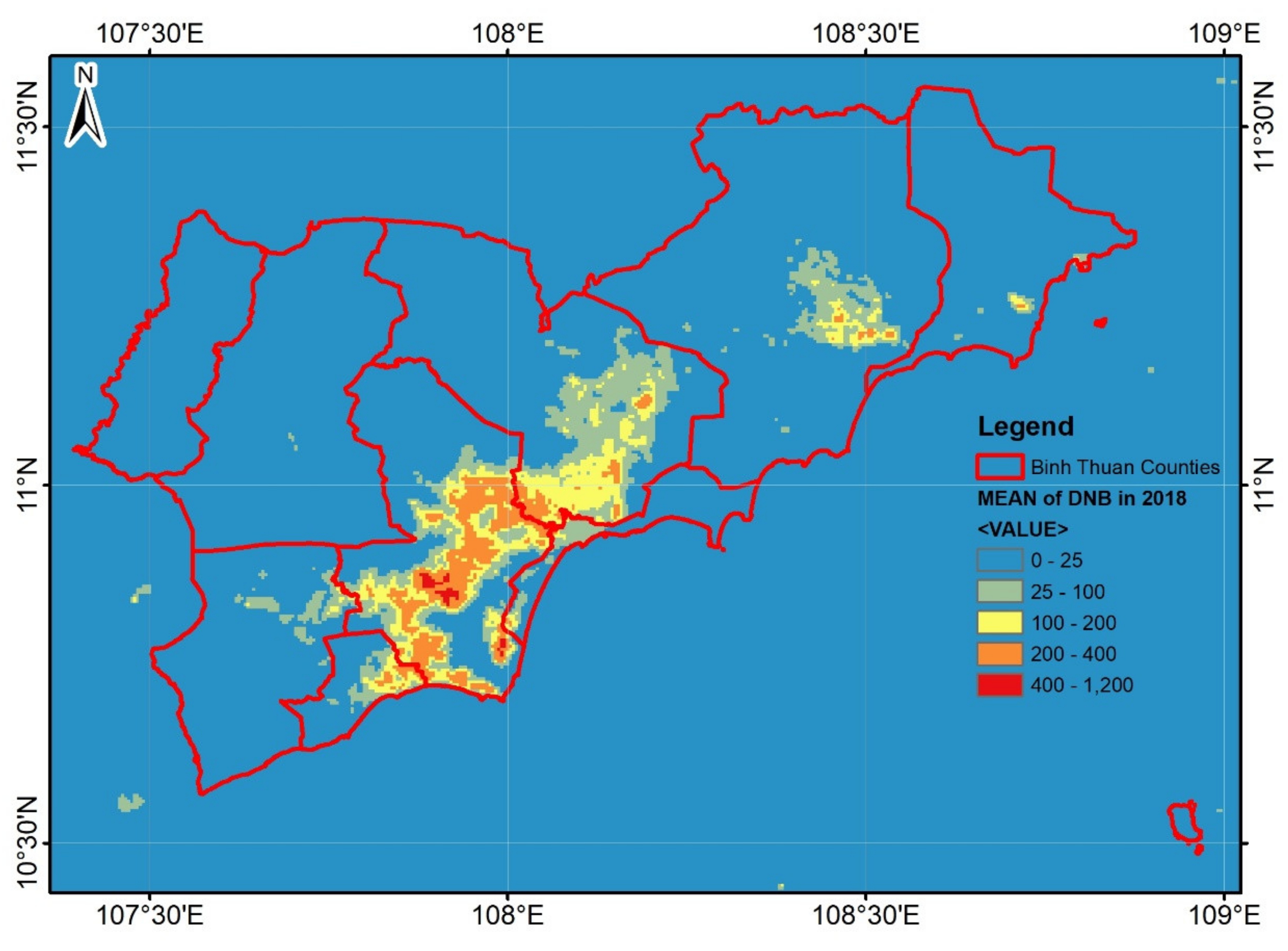
The mean values of DNB representing the spatial distribution of NTL brightness in Binh Thuan Province are shown in Figure 5. The mean values of DNB in 2018 were divided into five levels from 0 to 1200. The lower the value of DNB, the lower the brightness of NTL or the less the number of lights in the area. Conversely, the higher the value of DNB, the higher the brightness or the greater the number of lights. It can be seen from Figure 5 that the areas with higher light brightness in 2018 were distributed in the central area of Binh Thuan Province, centered at the two counties of Ham Thuan Nam and Ham Thuan Bac.
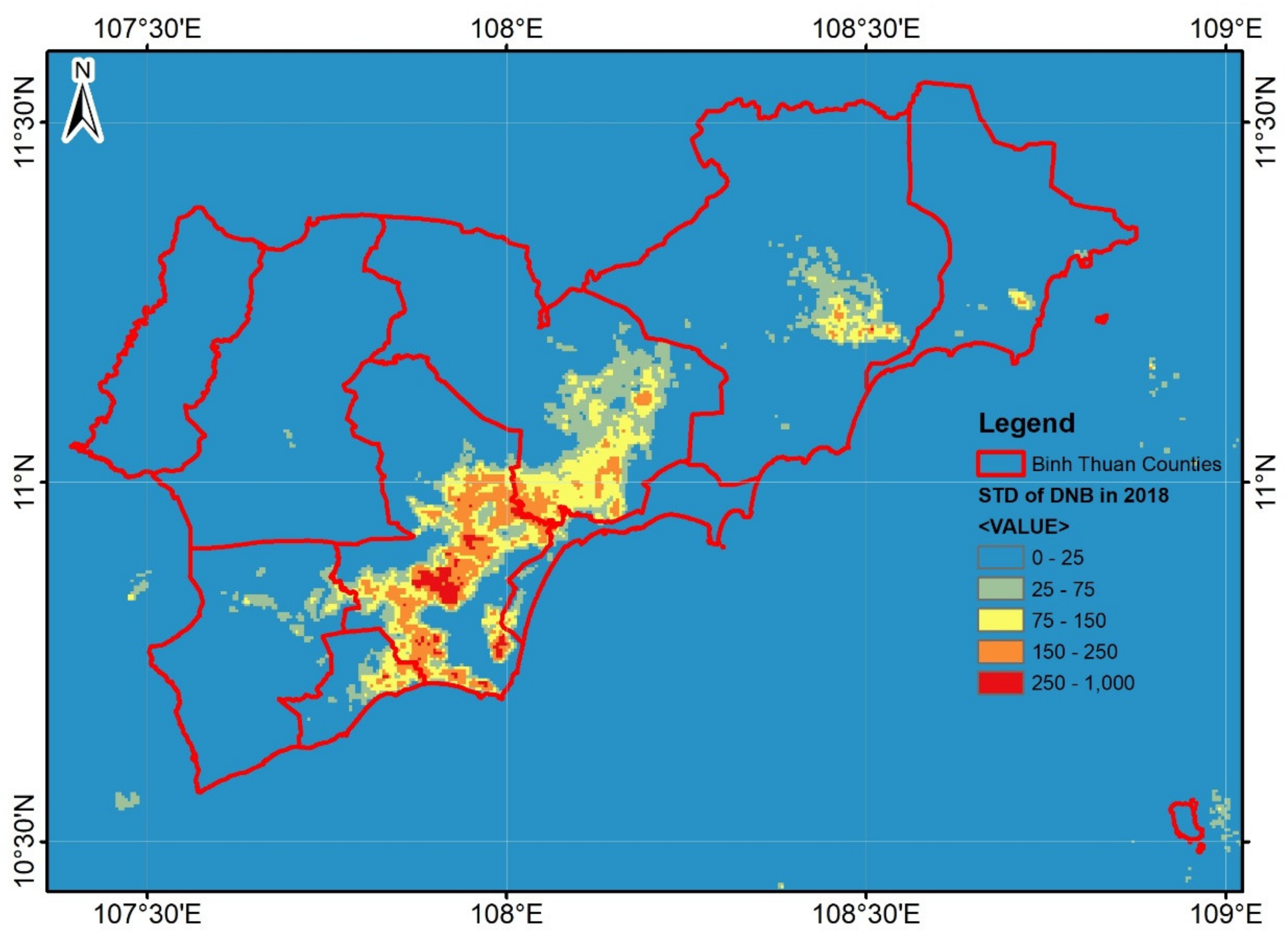
The standard deviation values of DNB representing the temporal series changes of NTL brightness in Binh Thuan Province are shown in Figure 6. The standard deviation values of DNB in 2018 were divided into five levels from 0 to 1000. The lower the value of the standard deviation of the DNB, the smaller the change in NTL brightness in the area. On the contrary, the higher the value, the greater the change in NTL brightness. It can be seen in Figure 6 that the areas with greater brightness changes in 2018 were distributed in the central area of Binh Thuan Province, centered on the two counties of Ham Thuan Nam and Ham Thuan Bac, basically in the same pattern as the distribution of NTL brightness.
3.2. Result of Relationship Analysis between NTL Brightness and Statistical Data
Through comparing the planted area, area having productions and production values of dragon fruit in each county of Binh Thuan Province with the sum of the MEAN values and STD values of DNB located in the same statistical area, the results of statistic calculation and correlation analyses were obtained and shown in Table 1 and Figure 7, Figure 8, Figure 9, Figure 10, Figure 11 and Figure 12.
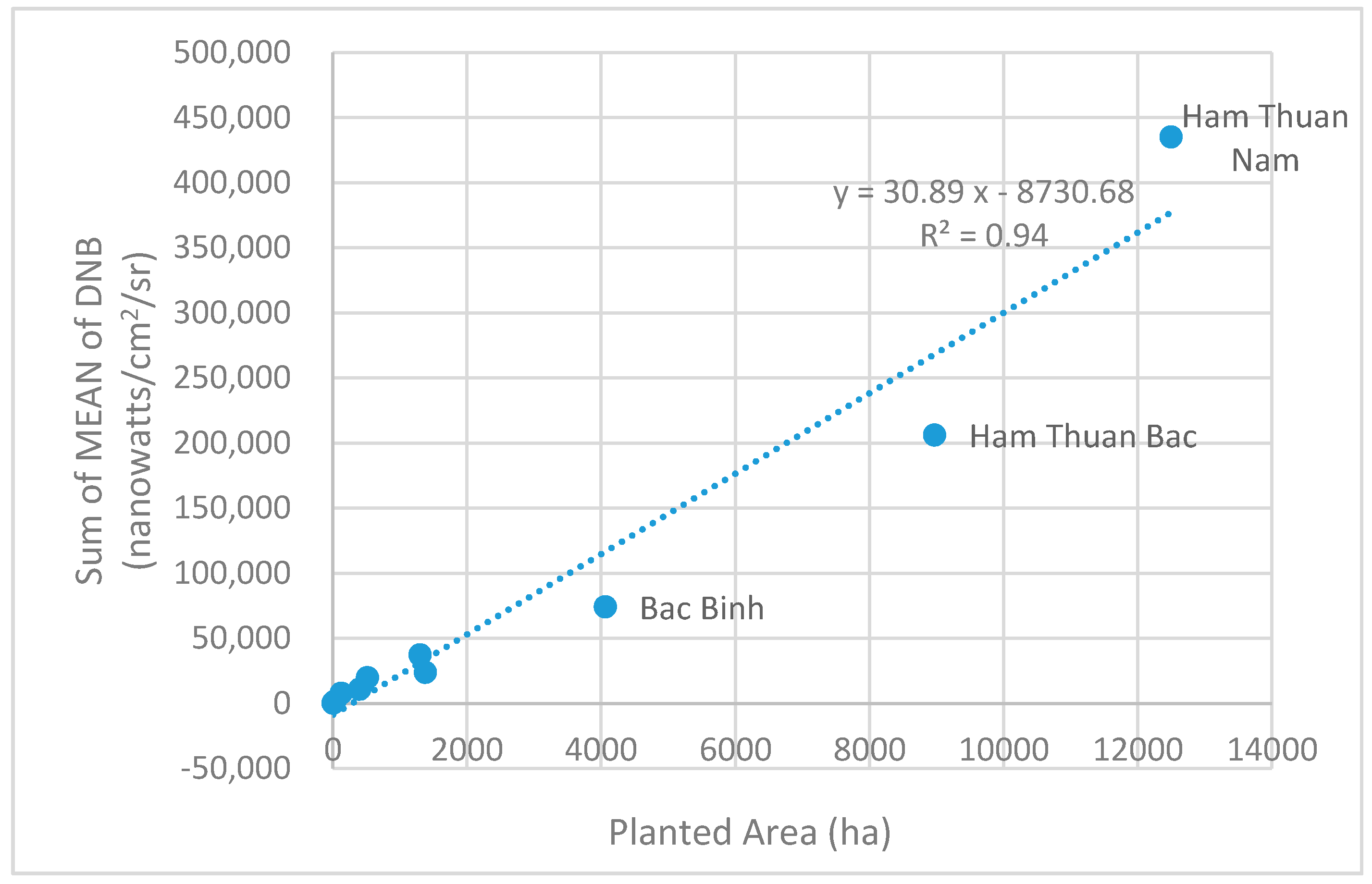
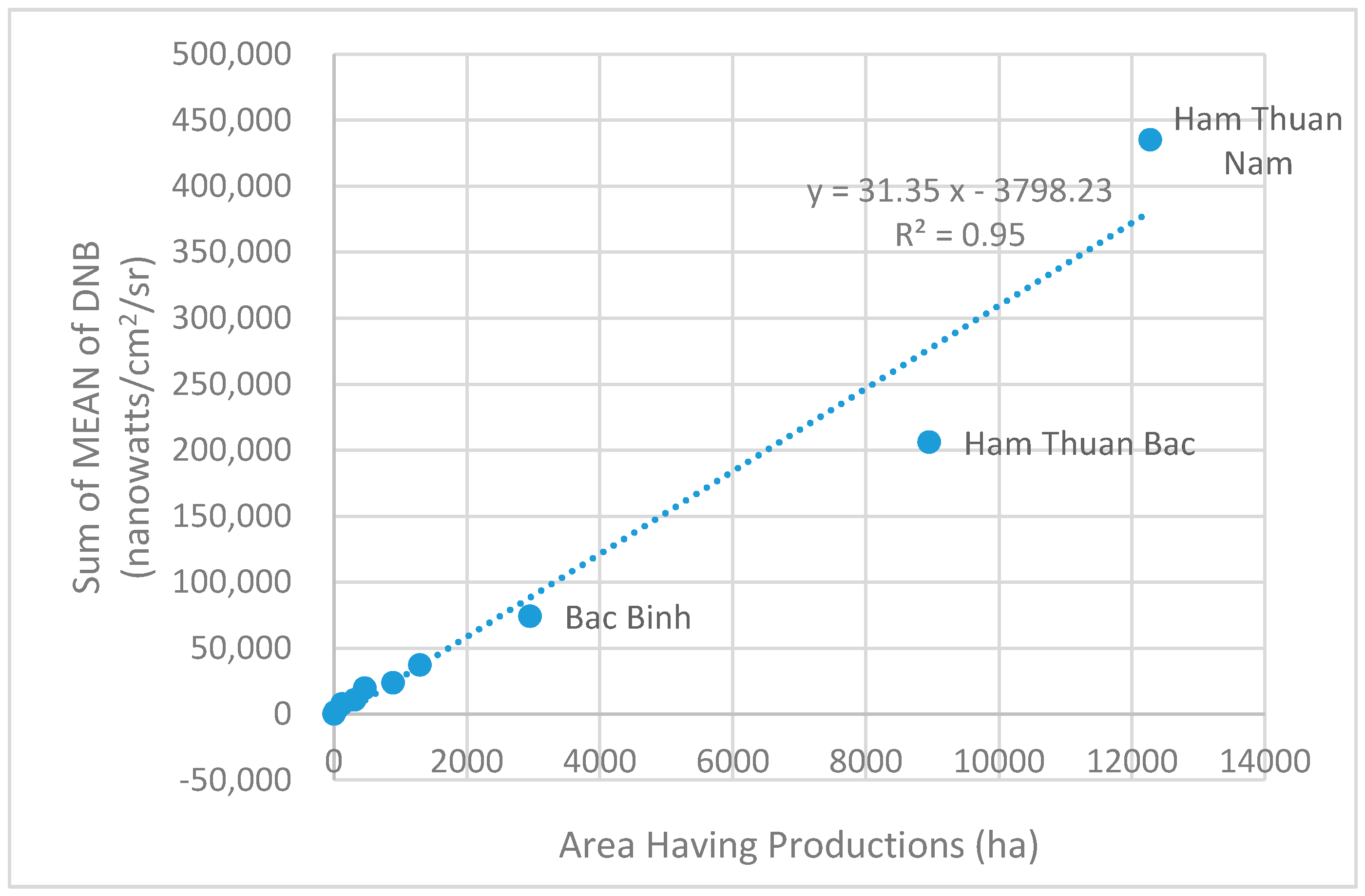
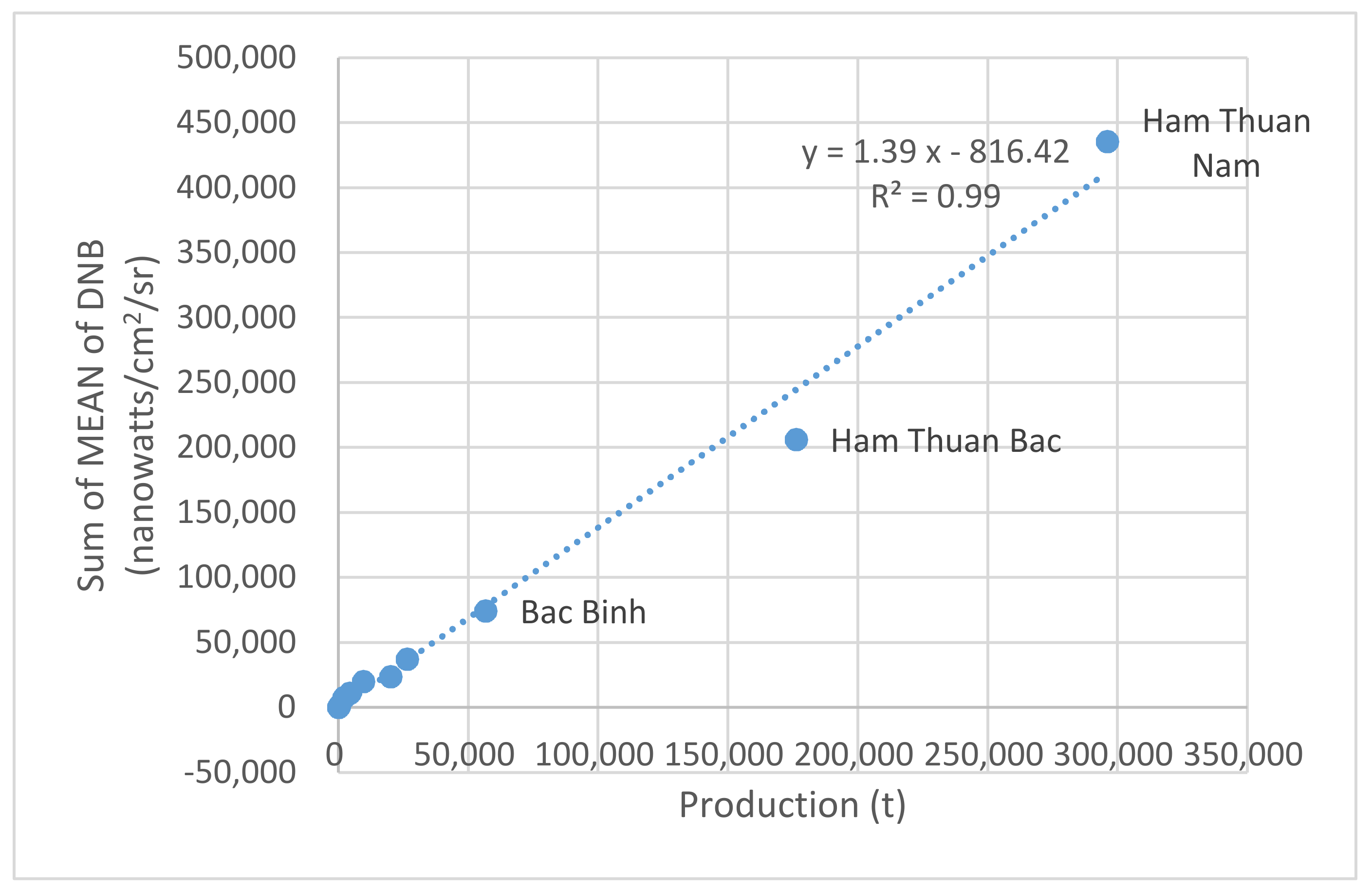
Figure 7, Figure 8 and Figure 9 show the relationship between the three statistical items of dragon fruit planted area, area having productions and production in each county and the sum of yearly mean NTL brightness value within the corresponding county. It can be seen that there was a significant positive correlation, and the coefficients of determination (R-squared) were 0.94, 0.95 and 0.99 respectively. However, from the top three values of the sum of mean, which were provided by counties of Ham Thuan Nam, Ham Thuan Bac and Bac Binh, it seems that there are nonlinear exponential relationships between the two variables.
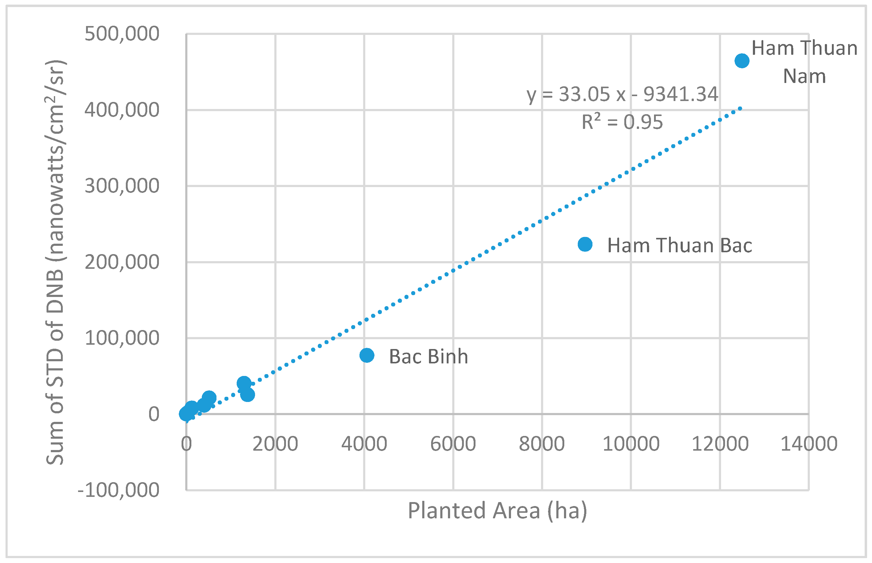
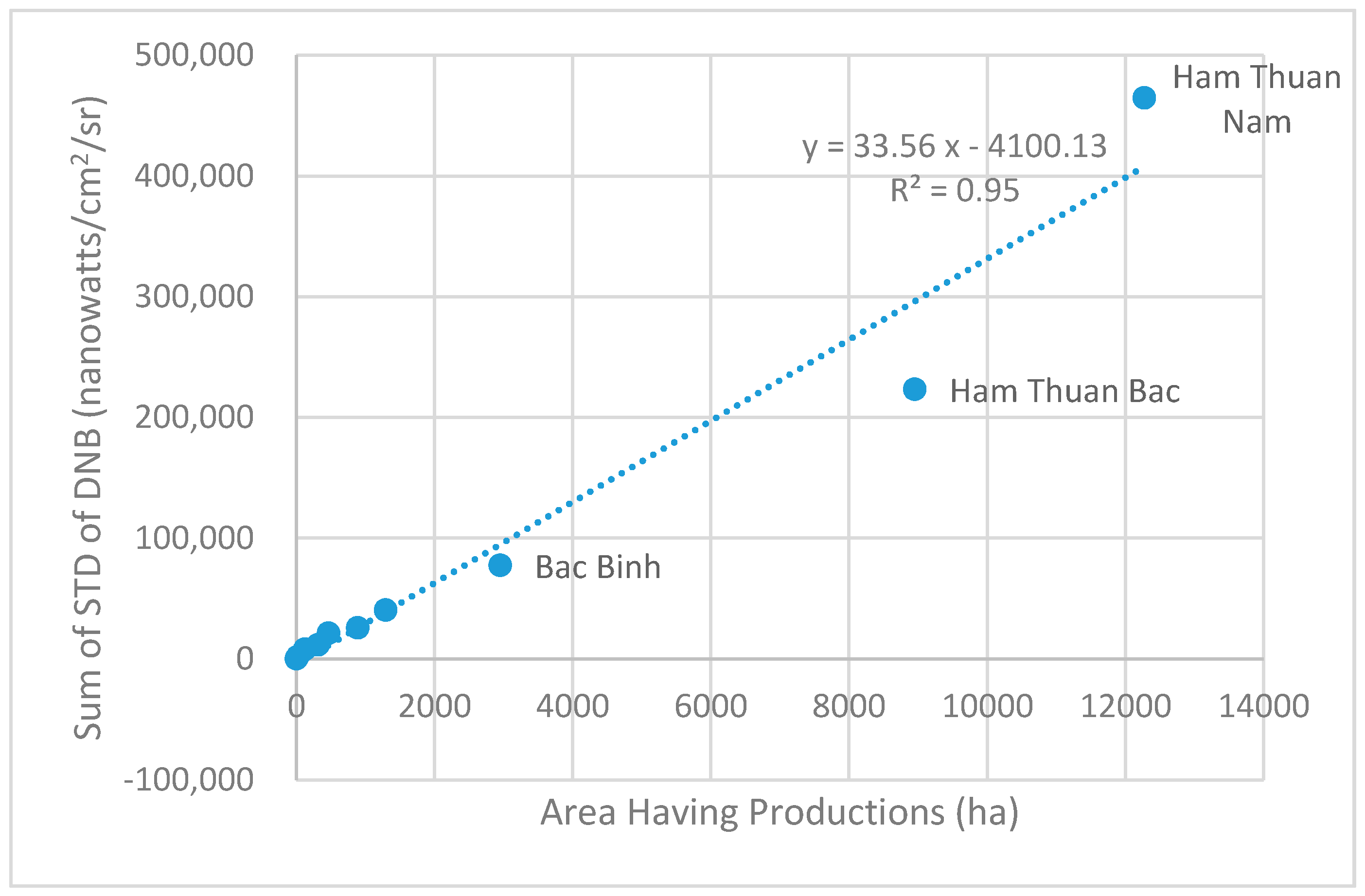
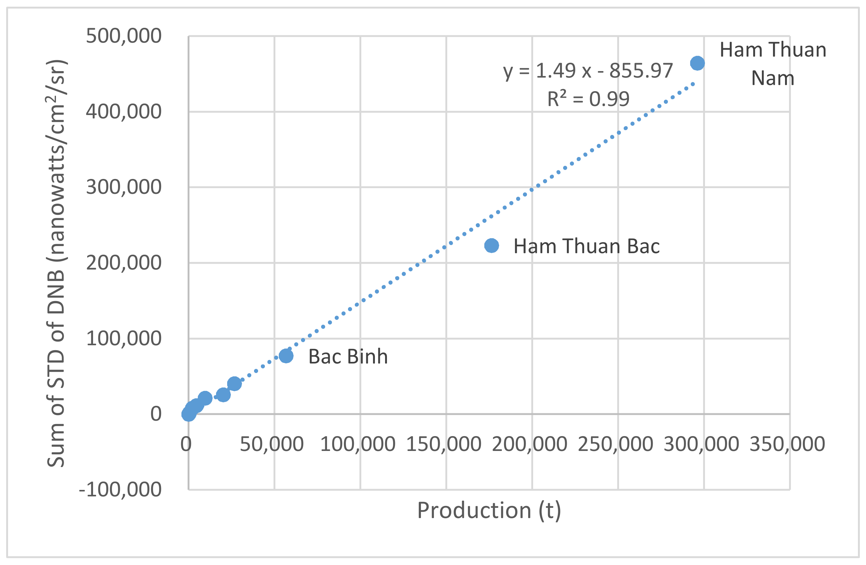
Figure 10, Figure 11 and Figure 12 show the relationships between the three statistical items and the sum of the standard deviation of yearly NTL brightness within the corresponding county. It can be seen that there were strong positive correlations, with similar correlation coefficients as shown in Figure 7, Figure 8 and Figure 9. Again, the top three values show nonlinear exponential relationships between the two variables.
Although dragon fruit production is controlled by daylight, artificial nightlight and other factors, the above results suggest that the sum of the mean and STD values of DNB in the statistical areas is an excellent measure of the cultivation, harvest and production of dragon fruit in Binh Thuan Province, Vietnam. In other words, NTL brightness is suitable for monitoring the agricultural behaviors and predicting production of dragon fruit or other similar crops, although the correlation cannot be determined precisely enough, limited by the small sample size. Additionally, such correlations do not necessarily imply causation.
4. Discussion
4.1. The Sources of NTLs
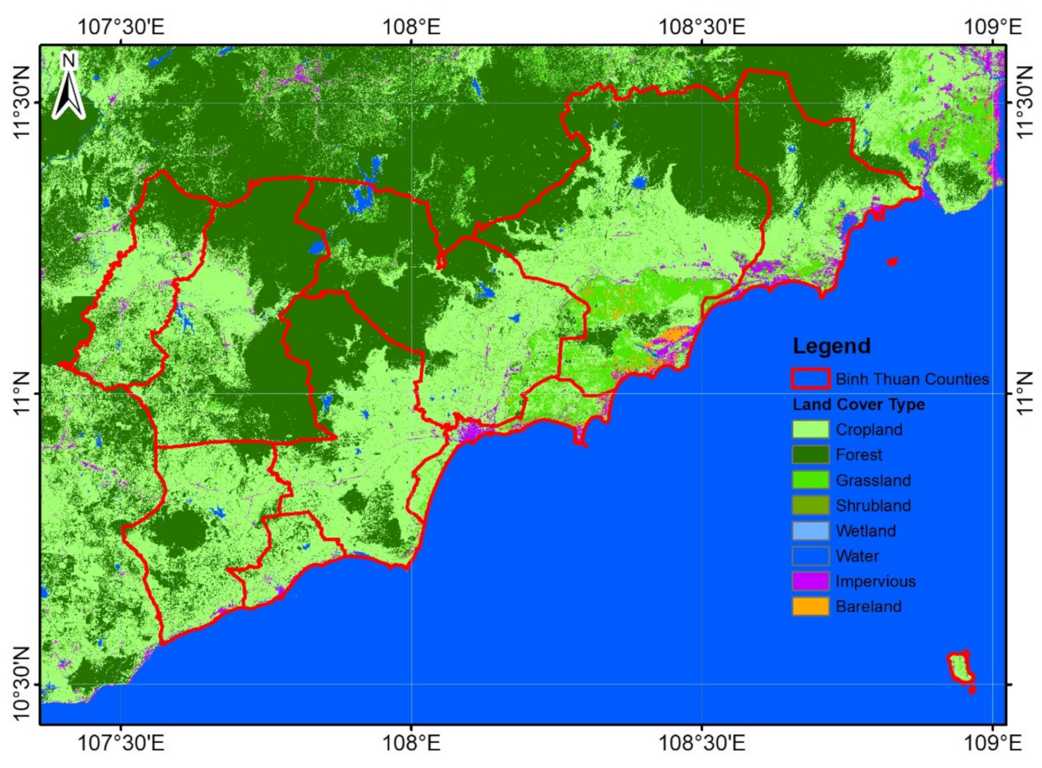
The source of NTLs is an important premise in NTL-related studies. It is generally believed that the main source of NTL is from the artificial lighting in cites. However in some cases such as this study area, NTLs in non-urban areas are more active than those in urban areas. To better understand the relationship between NTL brightness and human activities, the Land Cover dataset of 2017 from Tsinghua University was selected to support further analysis. The dataset was produced by the project of Finer Resolution Observation and Monitoring: Global Land Cover [38] (http://data.ess.tsinghua.edu.cn/fromglc10_2017v01.html) with a 30 m resolution. The land cover types of the tiles covering Binh Thuan Province are shown in Figure 13.
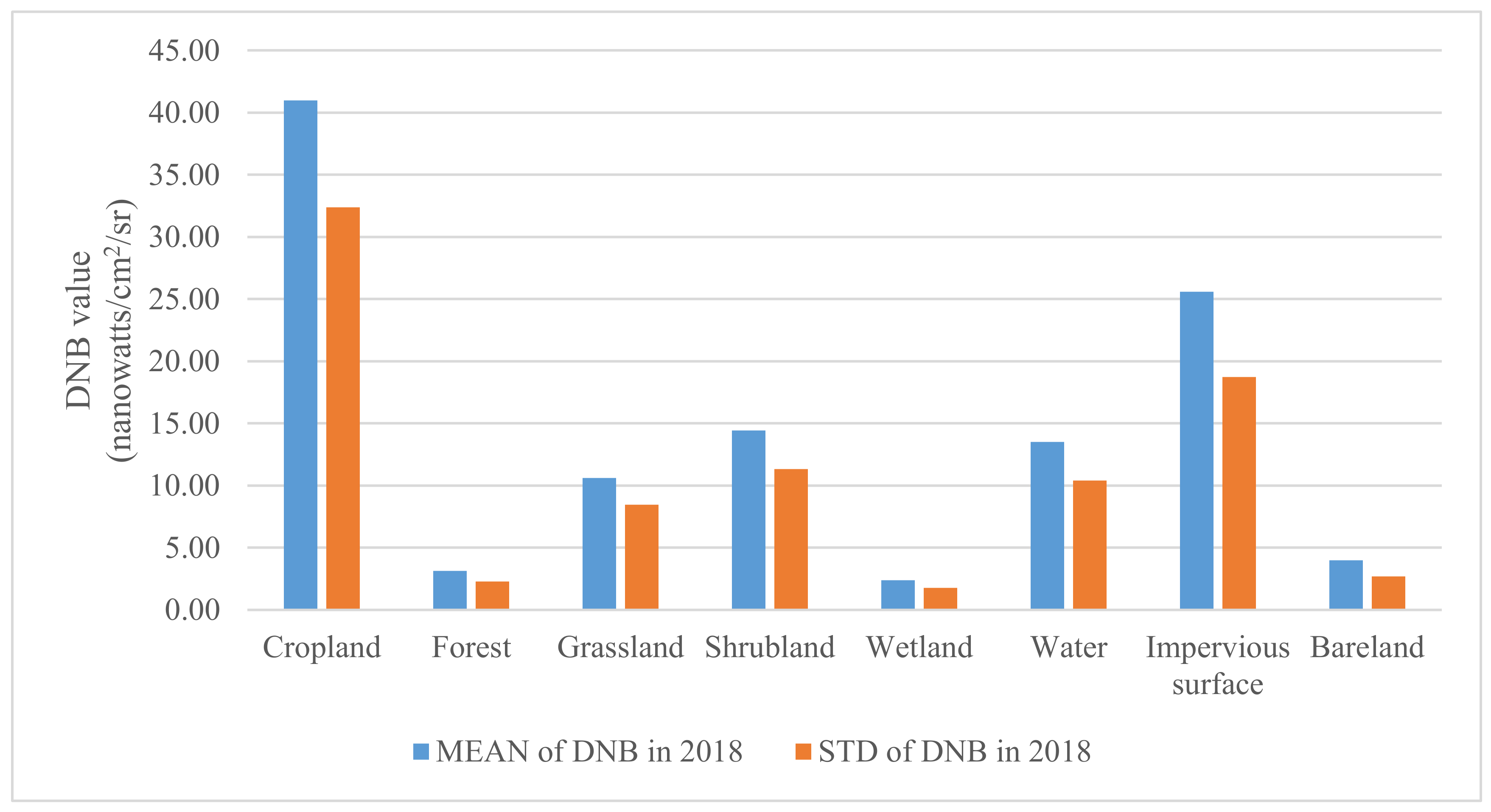
Figure 14 shows the mean and standard deviation of DNB values of 12 months for each land cover type in the study area, calculated using zonal statistics in ArcGIS. It can be seen that the mean brightness and annual changes of NTL in the croplands were the largest, followed by the impervious surfaces, which usually represent urban areas. The results suggest that there were a lot of night lights in the croplands where the mean brightness was much higher and the changes in brightness were larger than urban areas. It should be noted that the croplands in the land cover dataset include not only dragon fruit croplands but also other croplands. However, by comparing the DNB values from croplands and other land cover types in Figure 14, it is reasonable to believe that artificial lighting in dragon fruit croplands may be a major factor contributing to the high DNB values of the croplands.
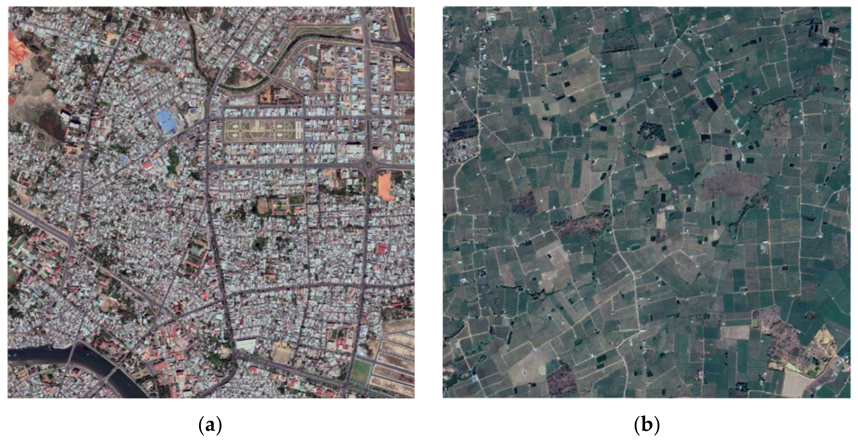
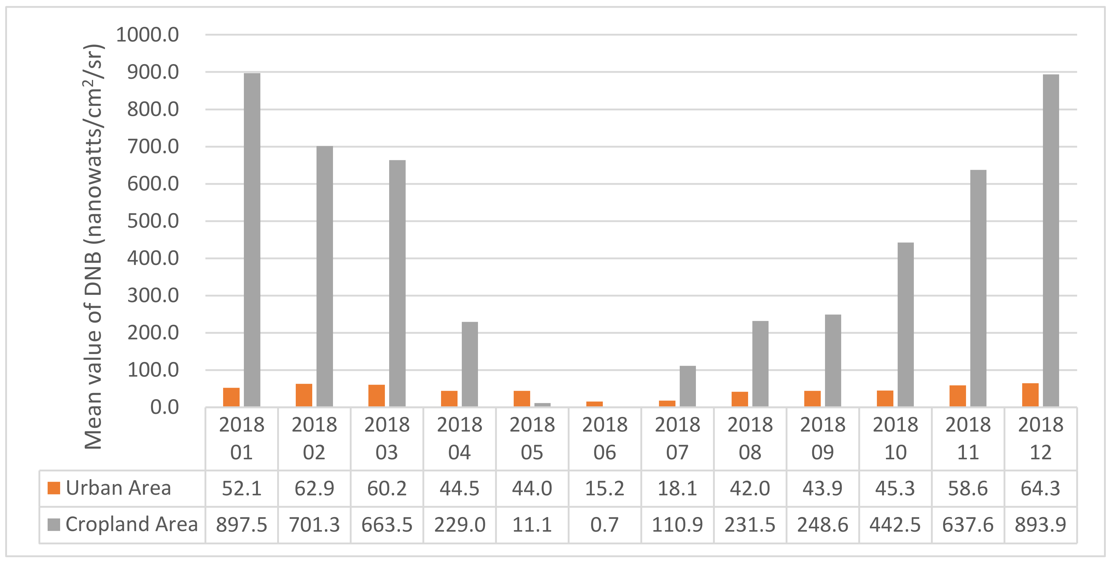
To show the changes in monthly composed NTL images in 2018, two 2 km by 2 km sample areas covering about 25 pixels each were selected from Phan Thiet City, the capital of Binh Thuan Province, and a dragon fruit plantation area in Ham Thuan Nam County. Aerial images of the two areas are shown in Figure 15. The monthly composite DNB values in these two areas from January to December 2018 were extracted, and the mean DNB values of all pixels in the two areas in Figure 15 were obtained to show the change of these two typical areas from January to December 2018 (Figure 16). The results in Figure 16 suggest that: (1) the mean DNB values of the cropland area are much larger than those of the urban area, except in May and June. (2) While the mean DNB values of the urban area are relatively stable throughout the year, the mean DNB values of the cropland area show a clear V-shaped pattern: declining from January to April, disappearing in May and June, and reappearing and increasing from July to December.
The strong seasonal variations of mean DNB values in the cropland area may be related to the monsoon climate in Binh Thuan Province. There is plenty of sunshine in the summer months from April to September, and substantial artificial lighting is not needed. However in the winter months from October to March, artificial lighting is needed to extend the flowering period of dragon fruit, and maintain the bearing period to increase production effectively. In May and June with the longest sunshine duration, the DNB values are basically 0 as artificial lighting is not needed, while in December and January with the shortest sunshine duration, the DNB values are the largest due to the increasing artificial lighting.
4.2. Discussion on Additional Factors
An important condition for mapping dragon fruit croplands using NTL remotely sensed data is the overlap between satellite pass time and artificial lighting duration in the croplands. Although this was not a problem for the study presented here, relationships between NTL data and artificial lighting in croplands cannot be established if the satellite overpass time does not overlap the artificial lighting period on the ground. Such limitations can be reduced or eliminated with the increase of the number of NTL remote sensing satellites and the observation periods.
The impact of clouds on NTL data is another factor. In the local dry season, clouds do not have much impact on the monthly composite data, but in the rainy season, cloud-cover may cause missing data in the monthly composite data, which will affect the calculation of the annual change statistics.
Since the study used data from statistical yearbooks collected at the county level, the sample size is limited to only 10 counties, which may affect the representativeness of the results. There are two ways to solve this problem in the future: one is to use more detailed statistical units, such as dragon fruit production farms, and the other is to use data from multiple years, which can effectively increase the sample size to make the results more meaningful. Besides, considering the small sample size and the skewed dataset, a nonparametric method may be more suitable for expressing the relationships than the parametric linear regression method.
5. Conclusions
As a test study on the application of nighttime light in agricultural monitoring, this paper presented methods and results for mapping dragon fruit croplands using NTL remote sensing of artificial light at night in Binh Thuan Province, Vietnam. The monthly composite data of NPP-VIIRS, land cover data and statistical yearbook data were used for mapping/monitoring the seasonal changes of NTL, extracting the scope and intensity of the supplementary light operation in the dragon fruit fields, and evaluating the monitoring effect of NTL remote sensing by comparing the planted area, area having productions and production of dragon fruit in the statistical yearbook. The results suggest that NTL remote sensing had great potential in estimating the planted area and production of dragon fruit. It is expected that the data and methods can be applied to similar agricultural application scenarios that involve artificial lighting at night, although issues such as satellite overpass time, cloud cover and ground sample size should be addressed.
Author Contributions
Conceptualization, W.S.; methodology, R.W. and W.S.; writing—original draft preparation, R.W. and W.S.; writing—review and editing, R.W., W.S. and P.D.; visualization, W.S.; supervision, R.W.; project administration, R.W. All authors have read and agreed to the published version of the manuscript.
Funding
This research was funded by National Natural Science Foundation of China: No.41971376.
Acknowledgments
The authors would like to thank the reviewers and editors for their helpful comments.
Conflicts of Interest
The authors declare no conflict of interest.
References
- Croft, T.A. Nighttime Images of the Earth from Space. Sci. Am. 1978, 239, 86–101. [Google Scholar] [CrossRef]
- Elvidge, C.D.; Baugh, K.; Zhizhin, M.; Hsu, F.C.; Ghosh, T. VIIRS night-time lights. Int. J. Remote Sens. 2017, 38, 5860–5879. [Google Scholar] [CrossRef]
- Zhao, M.; Zhou, Y.; Li, X.; Cao, W.; He, C.; Yu, B.; Elvidge, C.D.; Cheng, W.; Zhou, C. Applications of satellite remote sensing of nighttime light observations: Advances, challenges, and perspectives. Remote Sens. 2019, 11, 1971. [Google Scholar] [CrossRef] [Green Version]
- Ma, Q.; He, C.; Wu, J.; Liu, Z.; Zhang, Q.; Sun, Z. Quantifying spatiotemporal patterns of urban impervious surfaces in China: An improved assessment using nighttime light data. Landsc. Urban Plan. 2014, 130, 36–49. [Google Scholar] [CrossRef]
- Ma, T.; Zhou, C.; Pei, T.; Haynie, S.; Fan, J. Quantitative estimation of urbanization dynamics using time series of DMSP/OLS nighttime light data: A comparative case study from China’s cities. Remote Sens. Environ. 2012, 124, 99–107. [Google Scholar] [CrossRef]
- Xiao, P.; Wang, X.; Feng, X.; Zhang, X.; Yang, Y. Detecting China’s Urban Expansion Over the Past Three Decades Using Nighttime Light Data. IEEE J. Sel. Top. Appl. Earth Obs. Remote Sens. 2014, 7, 4095–4106. [Google Scholar] [CrossRef]
- Yao, Y.; Chen, D.; Chen, L.; Wang, H.; Guan, Q. A time series of urban extent in China using DSMP/OLS nighttime light data. PLoS ONE 2018, 13, e0198189. [Google Scholar] [CrossRef] [Green Version]
- Yu, B.; Shu, S.; Liu, H.; Song, W.; Wu, J.; Wang, L.; Chen, Z. Object-based spatial cluster analysis of urban landscape pattern using nighttime light satellite images: A case study of China. Int. J. Geogr. Inf. Sci. 2014, 28, 2328–2355. [Google Scholar] [CrossRef]
- Liu, Z.; He, C.; Zhang, Q.; Huang, Q.; Yang, Y. Extracting the dynamics of urban expansion in China using DMSP-OLS nighttime light data from 1992 to 2008. Landsc. Urban Plan. 2012, 106, 62–72. [Google Scholar] [CrossRef]
- Xin, X.; Liu, B.; Di, K.; Zhu, Z.; Zhao, Z.; Liu, J.; Yue, Z.; Zhang, G. Monitoring urban expansion using time series of night-time light data: A case study in Wuhan, China. Int. J. Remote Sens. 2017, 38, 6110–6128. [Google Scholar] [CrossRef]
- Wu, J.; Ma, L.; Li, W.; Peng, J.; Liu, H. Dynamics of Urban Density in China: Estimations Based on DMSP/OLS Nighttime Light Data. IEEE J. Sel. Top. Appl. Earth Obs. Remote Sens. 2014, 7, 4266–4275. [Google Scholar] [CrossRef]
- Wei, Y.; Liu, H.; Song, W.; Yu, B.; Xiu, C. Normalization of time series DMSP-OLS nighttime light images for urban growth analysis with Pseudo Invariant Features. Landsc. Urban Plan. 2014, 128, 1–13. [Google Scholar] [CrossRef]
- Zeng, C.; Zhou, Y.; Wang, S.; Yan, F.; Zhao, Q. Population spatialization in China based on night-time imagery and land use data. Int. J. Remote Sens. 2011, 32, 9599–9620. [Google Scholar] [CrossRef]
- Zhao, M.; Cheng, W.; Zhou, C.; Li, M.; Wang, N.; Liu, Q. GDP Spatialization and Economic Differences in South China Based on NPP-VIIRS Nighttime Light Imagery. Remote Sens. 2017, 9, 673. [Google Scholar] [CrossRef] [Green Version]
- Shi, K.; Chen, Y.; Yu, B.; Xu, T.; Yang, C.; Li, L.; Huang, C.; Chen, Z.; Liu, R.; Wu, J. Detecting spatiotemporal dynamics of global electric power consumption using DMSP-OLS nighttime stable light data. Appl. Energy 2016, 184, 450–463. [Google Scholar] [CrossRef]
- Yu, B.; Shi, K.; Hu, Y.; Huang, C.; Chen, Z.; Wu, J. Poverty Evaluation Using NPP-VIIRS Nighttime Light Composite Data at the County Level in China. IEEE J. Sel. Top. Appl. Earth Obs. Remote Sens. 2015, 8, 1–13. [Google Scholar] [CrossRef]
- Li, X.; Liu, S.; Jendryke, M.; Li, D.; Wu, C. Night-Time Light Dynamics during the Iraqi Civil War. Remote Sens. 2018, 10, 858. [Google Scholar] [CrossRef] [Green Version]
- Li, X.; Li, D. Can night-time light images play a role in evaluating the Syrian Crisis? Int. J. Remote Sens. 2014, 35, 6648–6661. [Google Scholar] [CrossRef]
- Kohiyama, M.; Hayashi, H.; Maki, N.; Higashida, M.; Kroehl, H.W.; Elvidge, C.D.; Hobson, V.R. Early damaged area estimation system using DMSP-OLS night-time imagery. Int. J. Remote Sens. 2004, 25, 2015–2036. [Google Scholar] [CrossRef]
- Bertinelli, L.; Mohan, P.; Strobl, E. Hurricane damage risk assessment in the Caribbean: An analysis using synthetic hurricane events and nightlight imagery. Ecol. Econ. 2016, 124, 135–144. [Google Scholar] [CrossRef]
- Chand, T.R.K.; Badarinath, K.; Murthy, M.S.R.; Rajshekhar, G.; Elvidge, C.D.; Tuttle, B.T. Active forest fire monitoring in Uttaranchal State, India using multi-temporal DMSP-OLS and MODIS data. Int. J. Remote Sens. 2007, 28, 2123–2132. [Google Scholar] [CrossRef]
- Elvidge, C.D.; Zhizhin, M.; Baugh, K.E.; Hsu, F.-C. Automatic Boat Identification System for VIIRS Low Light Imaging Data. Remote Sens. 2015, 7, 3020–3036. [Google Scholar] [CrossRef] [Green Version]
- Geronimo, R.C.; Franklin, E.C.; Brainard, R.E.; Elvidge, C.D.; Santos, M.D.; Venegas, R.; Mora, C. Mapping Fishing Activities and Suitable Fishing Grounds Using Nighttime Satellite Images and Maximum Entropy Modelling. Remote Sens. 2018, 10, 1604. [Google Scholar] [CrossRef] [Green Version]
- Li, Q.; Su, F.; Wang, W. Research on Oil and Gas Platform Extraction Technology Based on VIIRS Data. J. Geo Inf. Sci. 2017, 19, 398–406. [Google Scholar]
- Elvidge, C.D.; Zhizhin, M.; Baugh, K.E.; Hsu, F.-C.; Ghosh, T. Methods for Global Survey of Natural Gas Flaring from Visible Infrared Imaging Radiometer Suite Data. Energies 2015, 9, 14. [Google Scholar] [CrossRef]
- Ou, J.; Liu, X.; Li, X.; Shi, X. Mapping Global Fossil Fuel Combustion CO2Emissions at High Resolution by Integrating Nightlight, Population Density, and Traffic Network Data. IEEE J. Sel. Top. Appl. Earth Obs. Remote Sens. 2015, 9, 1674–1684. [Google Scholar] [CrossRef]
- Katz, Y.; Levin, N. Quantifying urban light pollution—A comparison between field measurements and EROS-B imagery. Remote Sens. Environ. 2016, 177, 65–77. [Google Scholar] [CrossRef]
- Kumari, S.A.S.M.; Mannanyake, M.A.D.K.; Warnasooriya, W.M.S.; Munasinghe, M.A.L.R.; Kannangara, K.N. Induced flowering with artificial light for year round production of dragon fruit in Sri Lanka. Ann. Sri Lanka Dep. Agric. 2016, 18, 114–128. [Google Scholar]
- Binh Thuan Provincial People’s Committee. Natural Condition of Binh Thuan Province. Available online: https://www.binhthuan.gov.vn/1413/37383/63648/natural-condition (accessed on 22 July 2020).
- Bình Thuận Province. Available online: https://en.wikipedia.org/wiki/Bình_Thuận_Province (accessed on 20 June 2020).
- Trinh, X.H.; Mai, V.Q.; Nguyen, T.H.; Nguyen, T.B.N.; Ha, M.T.; Nguyen, V.L. Dragon Fruit Production in Vietnam: Achievements and Challenges; FFTC Agricultural Policy Platform: Taipei, Taiwan, 2018. [Google Scholar]
- Phan, T.T.H. The Dragon Fruit Export Challenge and Experiences in Vietnam. Available online: http://ap.fftc.agnet.org/ap_db.php?id=1038 (accessed on 24 June 2020).
- Pascua, L.T.; Gabriel, M.L.S.; Gabriel, M.; Pascua, M.E. Evaluation of light bulbs and the use of foliar fertilizer during off-season production of dragon fruit. Fruit Crops. 2013. Available online: https://www.haifa-group.com/sites/default/files/crop/Evaluation_of_light_bulbs_and_the_use_of_foliar_fertilizer_to_induce_flowering.pdf (accessed on 28 October 2020).
- Levin, N.; Duke, Y. High spatial resolution night-time light images for demographic and socio-economic studies. Remote Sens. Environ. 2012, 119, 1–10. [Google Scholar] [CrossRef]
- Miller, S.D.; Straka, W.; Mills, S.P.; Elvidge, C.D.; Lee, T.F.; Solbrig, J.; Walther, A.; Heidinger, A.K.; Weiss, S.C. Illuminating the Capabilities of the Suomi National Polar-Orbiting Partnership (NPP) Visible Infrared Imaging Radiometer Suite (VIIRS) Day/Night Band. Remote Sens. 2013, 5, 6717–6766. [Google Scholar] [CrossRef] [Green Version]
- Elvidge, C.D.; Baugh, K.E.; Zhizhin, M.; Hsu, F.C. Why VIIRS data are superior to DMSP for mapping nighttime lights. Proc. Asia Pac. Adv. Netw. 2013, 35, 62. [Google Scholar] [CrossRef] [Green Version]
- Binh Thuan Statistical Office. Statistical Yearbook of Binh Thuan. 2018. Available online: http://www.cucthongke.vn/ngtk/2018/index.htm (accessed on 20 June 2020).
- Gong, P.; Liu, H.; Zhang, M.; Li, C.; Wang, J.; Huang, H.; Clinton, N.; Ji, L.; Li, W.; Bai, Y.; et al. Stable classification with limited sample: Transferring a 30-m resolution sample set collected in 2015 to mapping 10-m resolution global land cover in 2017. Sci. Bull. 2019, 64, 370–373. [Google Scholar] [CrossRef] [Green Version]
Figure 1.
Map of location and administrative divisions of the Binh Thuan Province.

Figure 2.
The monthly average day-length in the study area.

Figure 3.
National Polar Partnership (NPP)-Visible Infrared Imaging Radiometer Suite (VIIRS) nighttime light (NTL) monthly composite data of Binh Thuan Province from January to December 2018.
Figure 3.
National Polar Partnership (NPP)-Visible Infrared Imaging Radiometer Suite (VIIRS) nighttime light (NTL) monthly composite data of Binh Thuan Province from January to December 2018.

Figure 4.
Planted area, area having products and production of dragon fruit in Binh Thuan Province in 2018.
Figure 4.
Planted area, area having products and production of dragon fruit in Binh Thuan Province in 2018.

Figure 5.
The spatial distribution of NTL brightness of Binh Thuan Province in 2018.

Figure 6.
The temporal series changes of NTL brightness of Binh Thuan province in 2018.

Figure 7.
Pearson correlation between the sum of mean and the planted area of dragon fruit.

Figure 8.
Pearson correlation between the sum of mean and the area having productions of dragon fruit.
Figure 8.
Pearson correlation between the sum of mean and the area having productions of dragon fruit.

Figure 9.
Pearson correlation between the sum of mean and the production of dragon fruit.

Figure 10.
Pearson correlation between the sum of STD and the planted area of dragon fruit.

Figure 11.
Pearson correlation between the sum of STD and the area having productions of dragon fruit.
Figure 11.
Pearson correlation between the sum of STD and the area having productions of dragon fruit.

Figure 12.
Pearson correlation between the sum of STD and the production of dragon fruit.

Figure 13.
Land cover types of Binh Thuan Province in 2017.

Figure 14.
Chart of mean and standard deviation of day/night band (DNB) based on land cover types.

Figure 15.
Selected 2 km by 2 km areas for comparison. (a) Aerial image of the urban area on 6 March 2018 and (b) aerial image of the dragon fruit croplands on 12 February 2018.
Figure 15.
Selected 2 km by 2 km areas for comparison. (a) Aerial image of the urban area on 6 March 2018 and (b) aerial image of the dragon fruit croplands on 12 February 2018.

Figure 16.
Mean values of DNB in two typical areas from January to December 2018.


Table 1.
Statistical data for dragon fruit from official statistical yearbook and spatial calculation based on counties of Binh Thuan Province in 2018.
Table 1.
Statistical data for dragon fruit from official statistical yearbook and spatial calculation based on counties of Binh Thuan Province in 2018.
| County | Planted Area (ha) | Area Having Productions (ha) | Production (t) | Sum of Mean (nanowatts/cm2/sr) | Sum of STD (nanowatts/cm2/sr) |
|---|---|---|---|---|---|
| Phan Thiet | 513 | 463 | 9547.1 | 19,784 | 21,302 |
| La Gi | 1300 | 1291 | 26,504.3 | 37,295 | 40,457 |
| Tuy Phong | 400 | 314 | 4398 | 10,933 | 11,668 |
| Bac Binh | 4060 | 2950 | 56,640 | 74,142 | 77,393 |
| Ham Thuan Bac | 8970 | 8950 | 176,315 | 206,171 | 223,279 |
| Ham Thuan Nam | 12,497 | 12,275 | 295,997.5 | 435,311 | 464,495 |
| Tanh Linh | 125 | 122 | 2123 | 7692 | 8076 |
| Duc Linh | 28.9 | 18.2 | 386 | 1601 | 1675 |
| Ham Tan | 1377 | 887.8 | 20,053.6 | 23,759 | 25,664 |
| Phu Quy | 1 | 0.6 | 0.5 | 160 | 151 |
Publisher’s Note: MDPI stays neutral with regard to jurisdictional claims in published maps and institutional affiliations. |
© 2020 by the authors. Licensee MDPI, Basel, Switzerland. This article is an open access article distributed under the terms and conditions of the Creative Commons Attribution (CC BY) license (http://creativecommons.org/licenses/by/4.0/).
Share and Cite
MDPI and ACS Style
Wang, R.; Shi, W.; Dong, P. Mapping Dragon Fruit Croplands from Space Using Remote Sensing of Artificial Light at Night. Remote Sens. 2020, 12, 4139. https://doi.org/10.3390/rs12244139
AMA Style
Wang R, Shi W, Dong P. Mapping Dragon Fruit Croplands from Space Using Remote Sensing of Artificial Light at Night. Remote Sensing. 2020; 12(24):4139. https://doi.org/10.3390/rs12244139
Chicago/Turabian StyleWang, Ruirui, Wei Shi, and Pinliang Dong. 2020. "Mapping Dragon Fruit Croplands from Space Using Remote Sensing of Artificial Light at Night" Remote Sensing 12, no. 24: 4139. https://doi.org/10.3390/rs12244139
Note that from the first issue of 2016, this journal uses article numbers instead of page numbers. See further details here.