
Remote Sensing for International Peace and Security: Its Role and Implications

 , ,
, ,  ,
,  ,
,  ,
,  ,
,  and
and
Abstract
:
1. Introduction
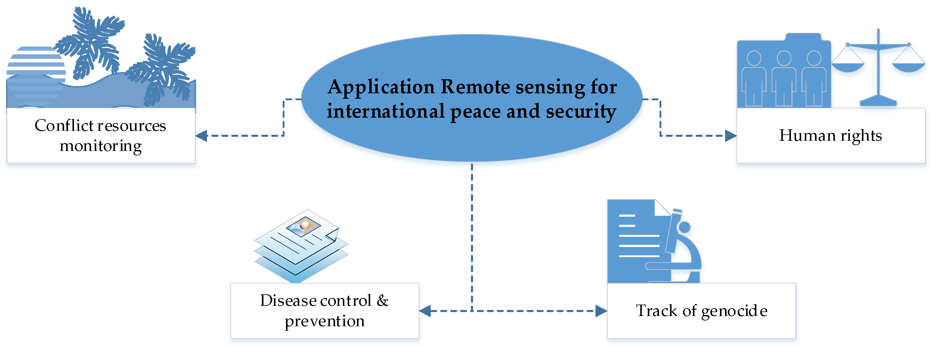
2. Methodology
2.1. Conceptual Issues
2.2. Selection of Related-Articles and Keywords
3. Results
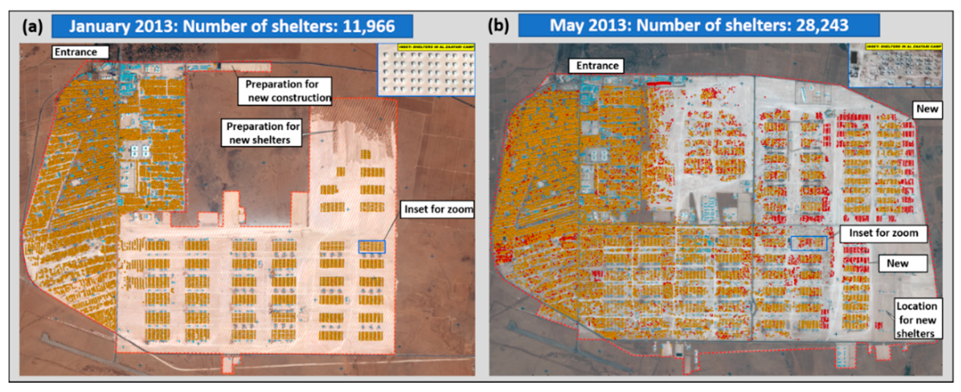
3.1. Remote Sensing for Refugee Relief Operations
3.2. Remote Sensing in Armed Conflicts
3.3. Remote Sensing in Tracking the Acts of Genocide
3.4. Remote Sensing in International Peace Missions
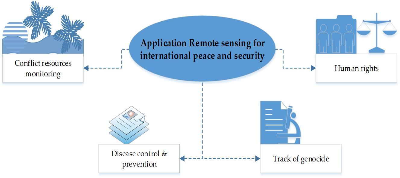
3.5. Applications in Peace and Conflict Areas
3.6. Remote Sensing and Human Rights
3.7. Remote Sensing for Disease Control and Prevention
4. Discussion
5. Future Perspectives
5.1. Technology Development Perspective
5.1.1. Use of New Sensors
5.1.2. UAV-Based Survey
5.1.3. Internet of Things (IoT) Based Survey
5.1.4. Visual Inertial System
5.1.5. Simultaneous Localization and Mapping
5.2. Conflict Management Perspective
5.2.1. Conflict Prevention
5.2.2. Peacekeeping
5.2.3. Peacemaking and Peace Enforcement
5.2.4. Peacebuilding
6. Conclusions
Author Contributions
Funding
Data Availability Statement
Acknowledgments
Conflicts of Interest
References
- Lessnoff, M. Social Contract; Macmillan Education: London, UK, 1986; ISBN 978-0-333-36791-9. [Google Scholar]
- Stokes, D.E. Pasteur’s Quadrant: Basic Science and Technological Innovation; Brookings Institution Press: Washington, DC, USA, 2011; ISBN 978-0-8157-1907-6. [Google Scholar]
- Barbier, E. Natural Resources and Economic Development; Cambridge University Press: Cambridge, UK, 2007; ISBN 978-0-521-70651-3. [Google Scholar]
- The World Bank. World Development Report 1993: Investing in Health; The World Bank Group: Washington, DC, USA, 1993; Volume 1. [Google Scholar]
- Kääb, A. Remote sensing of mountain environment. In Proceedings of the Projecting Global Change Impacts and Sustainable Land Use and Natural Resources Management in Mountain Biosphere Reserves, Pinos Genil, Spain, 14 March 2005; UNESCO: Pinos Genil, Spain; p. 92. [Google Scholar]
- Campbell, J.B. Origins of Aerial Photographic Interpretation, U.S. Army, 1916 to 1918. Photogramm. Eng. Remote. Sens. 2008, 74, 77–93. [Google Scholar] [CrossRef] [Green Version]
- Stichelbaut, B. The application of First World War aerial photography to archaeology: The Belgian images. Antiquity 2006, 80, 161–172. [Google Scholar] [CrossRef]
- Thomas, R.; Joseph, S.S. Emendation of undesirable attack on multiparty data sharing with anonymous Id assignment using AIDA algorithm. Innov. Syst. Des. Eng. 2015, 6, 6. [Google Scholar]
- Lee, R.J.; Steele, S.L. Military use of satellite communications, remote sensing, and global positioning systems in the war on terror. J. Air L. Com. 2014, 79, 69. [Google Scholar]
- Jasani, B.; Pesaresi, M.; Schneiderbauer, S.; Zeug, G. Remote Sensing from Space: Supporting International Peace and Security; Springer Science & Business Media: Berlin/Heidelberg, Germany, 2009; ISBN 1-4020-8484-6. [Google Scholar]
- Dashora, A.; Lohani, B.; Malik, J.N. A repository of earth resource information—CORONA satellite programme. Curr. Sci. 2007, 92, 926–932. [Google Scholar]
- Roy, S. The Palestinian-Israeli Conflict and Palestinian socioeconomic decline: A place denied. Int. J. Politics Cult. Soc. 2003, 17, 365–403. [Google Scholar] [CrossRef]
- Singhal, A. In Search of Military GIS. Geospat. World 2009. Available online: https://www.geospatialworld.net/article/in-search-of-military-gis/ (accessed on 5 May 2020).
- United Nations (Ed.) Handbook on Geospatial Infrastructure in Support of Census Activities; Studies in Methods, Series F; United Nations: New York, NY, USA, 2009; ISBN 978-92-1-161527-2. [Google Scholar]
- Rizi, S.M.M.; Geller, A. Merging Remote Sensing Data and Population Surveys in Large, Empirical Multiagent Models: The Case of the Afghan Drug Industry; George Mason University: Fairfax, VA, USA, 2010; p. 8. [Google Scholar]
- Brown, I. Assessing eco-scarcity as a cause of the outbreak of conflict in Darfur: A remote sensing approach. Int. J. Remote. Sens. 2010, 31, 2513–2520. [Google Scholar] [CrossRef] [Green Version]
- Soytong, P.; Perera, R. Use of GIS tools for environmental conflict resolution at map ta phut industrial zone in Thailand. Sustainability 2014, 6, 2435–2458. [Google Scholar] [CrossRef] [Green Version]
- Hay, S.I. Remote sensing and disease control: Past, present and future. Trans. R. Soc. Trop. Med. Hyg. 1997, 91, 105–106. [Google Scholar] [CrossRef] [Green Version]
- Sulik, J.J.; Edwards, S. Feature extraction for Darfur: Geospatial applications in the documentation of human rights abuses. Int. J. Remote Sens. 2010, 31, 2521–2533. [Google Scholar] [CrossRef] [Green Version]
- Annual Report of the United Nations High Commissioner for Human Rights and Reports of the Office of the High Commissioner and the Secretary-General; Report on the Prevention of Genocide; Human Rights Council: Geneva, Switzerland, 2019.
- UNEP (United Nations Environment Programme). The Environmental Food Crisis: The Environment’s Role in Averting Future Food Crises: A UNEP Rapid Response Assessment; UNEP/Earthprint: Nairobi, Kenya, 2009; ISBN 978-82-7701-054-0. [Google Scholar]
- Hettling, J.K. The use of remote sensing satellites for verification in international law. Space Policy 2003, 19, 33–39. [Google Scholar] [CrossRef]
- Avtar, R.; Sahu, N.; Aggarwal, A.K.; Chakraborty, S.; Kharrazi, A.; Yunus, A.P.; Dou, J.; Kurniawan, T.A. Exploring renewable energy resources using remote sensing and GIS—A review. Resources 2019, 8, 149. [Google Scholar] [CrossRef] [Green Version]
- Estoque, R.C. A review of the sustainability concept and the state of SDG monitoring using remote sensing. Remote Sens. 2020, 12, 1770. [Google Scholar] [CrossRef]
- Avtar, R.; Aggarwal, R.; Kharrazi, A.; Kumar, P.; Kurniawan, T.A. Utilizing geospatial information to implement SDGs and monitor their Progress. Environ. Monit. Assess. 2020, 192, 35. [Google Scholar] [CrossRef]
- Jasani, B.; Larsson, C. Security implications of remote sensing. Space Policy 1988, 4, 46–59. [Google Scholar] [CrossRef]
- Abramson, S.F.; Carter, D.B. The historical origins of territorial disputes. Am. Political Sci. Rev. 2016, 110, 675–698. [Google Scholar] [CrossRef]
- Pech, L.; Lakes, T. The impact of armed conflict and forced migration on urban expansion in Goma: Introduction to a simple method of satellite-imagery analysis as a complement to field research. Appl. Geogr. 2017, 88, 161–173. [Google Scholar] [CrossRef]
- Sawalhah, M.N.; Al-Kofahi, S.D.; Othman, Y.A.; Cibils, A.F. Assessing rangeland cover conversion in Jordan after the Arab spring using a remote sensing approach. J. Arid. Environ. 2018, 157, 97–102. [Google Scholar] [CrossRef]
- Shatnawi, N.; Weidner, U.; Hinz, S. Monitoring urban expansion as a result of refugee fluxes in north jordan using remote sensing techniques. J. Urban. Plan. Dev. 2020, 146, 04020026. [Google Scholar] [CrossRef]
- Levin, N.; Ali, S.H.; Crandall, D. Utilizing remote sensing and big data to quantify conflict intensity: The Arab Spring as a case study. Appl. Geogr. 2018, 94, 1–17. [Google Scholar] [CrossRef]
- Weidmann, N.B.; Rød, J.K.; Cederman, L.-E. Representing ethnic groups in space: A new dataset. J. Peace Res. 2010, 47, 491–499. [Google Scholar] [CrossRef] [Green Version]
- Avtar, R.; Komolafe, A.A.; Kouser, A.; Singh, D.; Yunus, A.P.; Dou, J.; Kumar, P.; Das Gupta, R.; Johnson, B.A.; Minh, H.V.T.; et al. Assessing sustainable development prospects through remote sensing: A review. Remote. Sens. Appl. Soc. Environ. 2020, 20, 100402. [Google Scholar] [CrossRef]
- Starr, H. Opportunity, willingness and geographic information systems (GIS): Reconceptualizing borders in international relations. Politi. Geogr. 2002, 21, 243–261. [Google Scholar] [CrossRef]
- Branch, J. Geographic information systems (GIS) in international relations. Int. Organ. 2016, 70, 845–869. [Google Scholar] [CrossRef]
- Baldwin, D.A. The concept of security. Rev. Int. Stud. 1997, 23, 5–26. [Google Scholar] [CrossRef] [Green Version]
- Anderson, R. A Definition of peace. Peace Confl. 2004, 10, 101. [Google Scholar] [CrossRef]
- White, N.D. Keeping the Peace: The United Nations and the Maintenance of International Peace and Security; Manchester University Press: Manchester, UK, 1997. [Google Scholar]
- Galtung, J.; Fischer, D. Positive and negative peace. In Johan Galtung; SpringerBriefs on Pioneers in Science and Practice; Springer: Berlin/Heidelberg, Germany, 2013; Volume 5, pp. 173–178. ISBN 978-3-642-32480-2. [Google Scholar]
- Thomas, C.; Wilkin, P. Globalization, Human Security, and the African Experience; Lynne Rienner Publishers: Boulder, CO, USA, 1999; ISBN 1-55587-699-4. [Google Scholar]
- Cederman, L.-E.; Gleditsch, K.S.; Buhaug, H. Inequality, Grievances, and Civil War; Cambridge Studies in Contentious Politics; Cambridge University Press: New York, NY, USA, 2013; ISBN 978-1-107-01742-9. [Google Scholar]
- Dalen, Ø.; Johannessen, O.; Bjørgo, E.; Babiker, M.; Andersen, G. Use of ERS SAR Imagery in Refugee Relief; ESTEC: Nordwijk, The Netherlands, 2000. [Google Scholar]
- Bjorgo, E. Using very high spatial resolution multispectral satellite sensor imagery to monitor refugee camps. Int. J. Remote Sens. 2000, 21, 611–616. [Google Scholar] [CrossRef]
- Dysart, M.D. Remote Sensing and Mass Migration Policy Development; Air War College, Air University: Montgomery, AL, USA, 2012. [Google Scholar]
- Giada, S.; De Groeve, T.; Ehrlich, D.; Soille, P. Information extraction from very high resolution satellite imagery over Lukole refugee camp, Tanzania. Int. J. Remote Sens. 2003, 24, 4251–4266. [Google Scholar] [CrossRef]
- Quinn, J.A.; Nyhan, M.M.; Navarro, C.; Coluccia, D.; Bromley, L.; Luengo-Oroz, M. Humanitarian applications of machine learning with remote-sensing data: Review and case study in refugee settlement mapping. Philos. Trans. R. Soc. A Math. Phys. Eng. Sci. 2018, 376, 20170363. [Google Scholar] [CrossRef] [Green Version]
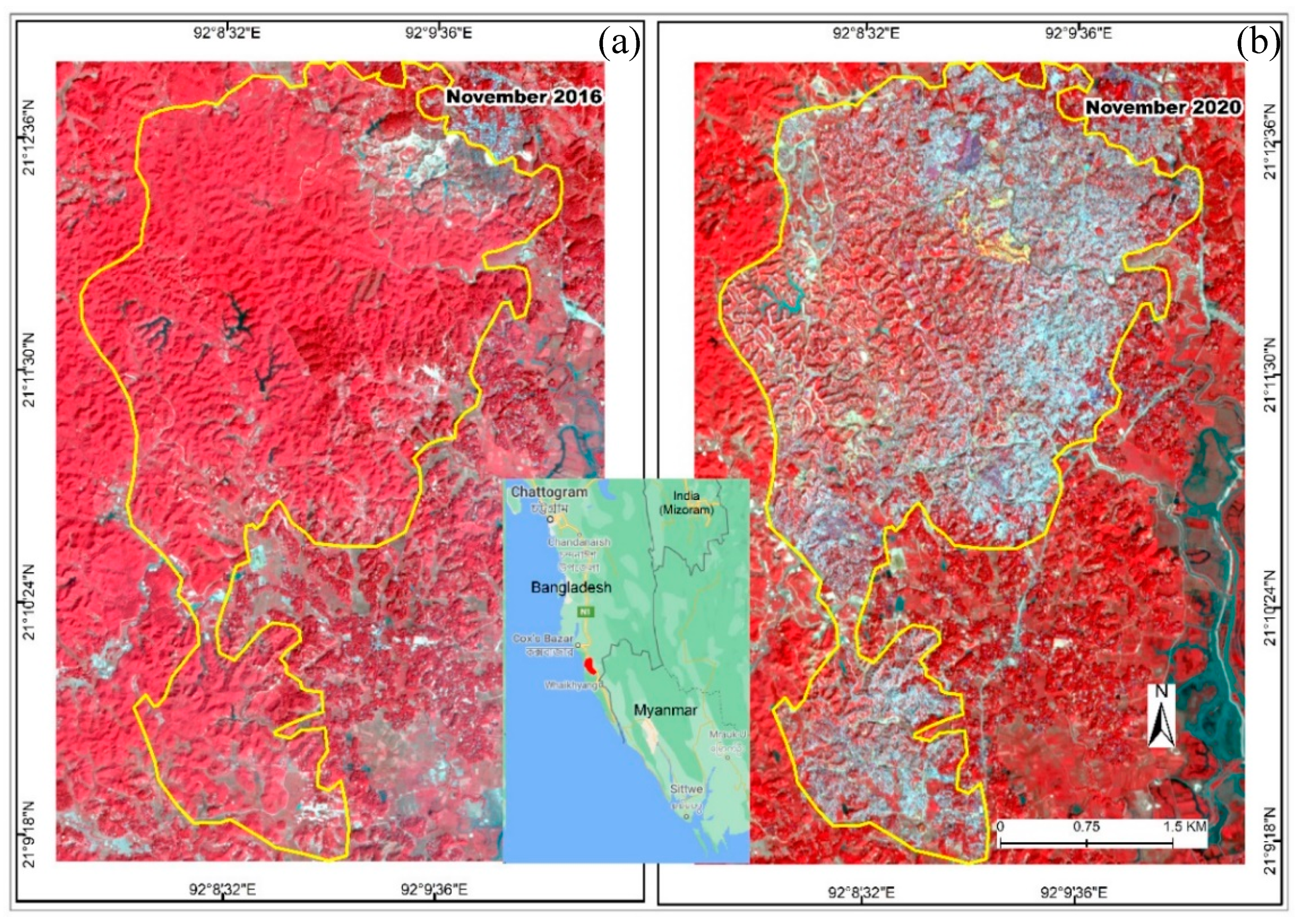
- Hassan, M.M.; Smith, A.C.; Walker, K.; Rahman, M.K.; Southworth, J. Rohingya refugee crisis and forest cover change in Teknaf, Bangladesh. Remote Sens. 2018, 10, 689. [Google Scholar] [CrossRef] [Green Version]
- Gorsevski, V.; Kasischke, E.S.; Dempewolf, J.; Loboda, T.; Grossmann, F. Analysis of the Impacts of armed conflict on the Eastern Afromontane forest region on the South Sudan—Uganda border using multitemporal Landsat imagery. Remote Sens. Environ. 2012, 118, 10–20. [Google Scholar] [CrossRef]
- Jiang, W.; He, G.; Long, T.; Liu, H. Ongoing conflict makes yemen dark: From the perspective of nighttime light. Remote Sens. 2017, 9, 798. [Google Scholar] [CrossRef] [Green Version]
- Prem, M.; Saavedra, S.; Vargas, J.F. End-of-conflict deforestation: Evidence from Colombia’s peace agreement. World Dev. 2020, 129, 104852. [Google Scholar] [CrossRef]
- Bromley, D.W. Environment and Economy: Property Rights and Public Policy; Basil Blackwell Ltd., University of Wisconsin-Madison: Madison, WI, USA, 1991. [Google Scholar]
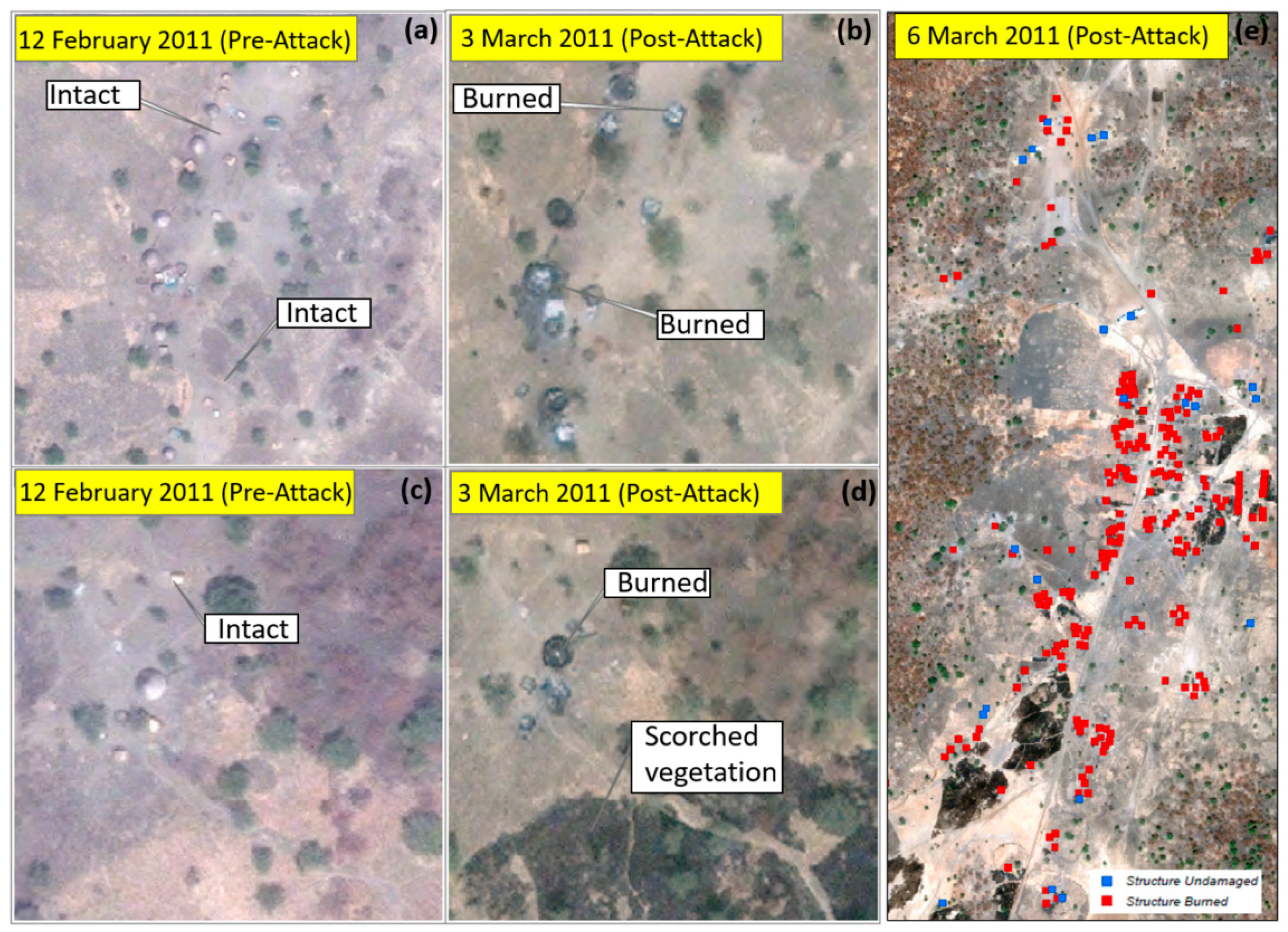
- Marx, A.; Loboda, T. Landsat-based early warning system to detect the destruction of villages in Darfur, Sudan. Remote Sens. Environ. 2013, 136, 126–134. [Google Scholar] [CrossRef]
- Prins, E. Use of low cost Landsat ETM+ to spot burnt villages in Darfur, Sudan. Int. J. Remote Sens. 2007, 29, 1207–1214. [Google Scholar] [CrossRef]
- Anderson, D.M.; Lochery, E. Violence and exodus in Kenya’s rift valley, 2008: Predictable and preventable? J. East. Afr. Stud. 2008, 2, 328–343. [Google Scholar] [CrossRef]
- Lee, C.; De Vries, W.T. Bridging the semantic gap between land tenure and EO data: Conceptual and methodological underpinnings for a geospatially informed analysis. Remote Sens. 2020, 12, 255. [Google Scholar] [CrossRef] [Green Version]
- Avtar, R.; Singh, D.; Umarhadi, D.A.; Yunus, A.P.; Misra, P.; Desai, P.N.; Kouser, A.; Kurniawan, T.A.; Phanindra, K. Impact of COVID-19 lockdown on the fisheries sector: A case study from three harbors in western India. Remote Sens. 2021, 13, 183. [Google Scholar] [CrossRef]
- Levin, N.; Ali, S.H.; Crandall, D.; Kark, S. World Heritage in danger: Big data and remote sensing can help protect sites in conflict zones. Glob. Environ. Chang. 2019, 55, 97–104. [Google Scholar] [CrossRef]
- Knoth, C. Combining automatic and manual image analysis in a web-mapping application for collaborative conflict damage assessment. Appl. Geogr. 2018, 97, 25–34. [Google Scholar] [CrossRef]
- Hagenlocher, M.; Lang, S.; Tiede, D. Integrated assessment of the environmental impact of an IDP camp in Sudan based on very high resolution multi-temporal satellite imagery. Remote Sens. Environ. 2012, 126, 27–38. [Google Scholar] [CrossRef]
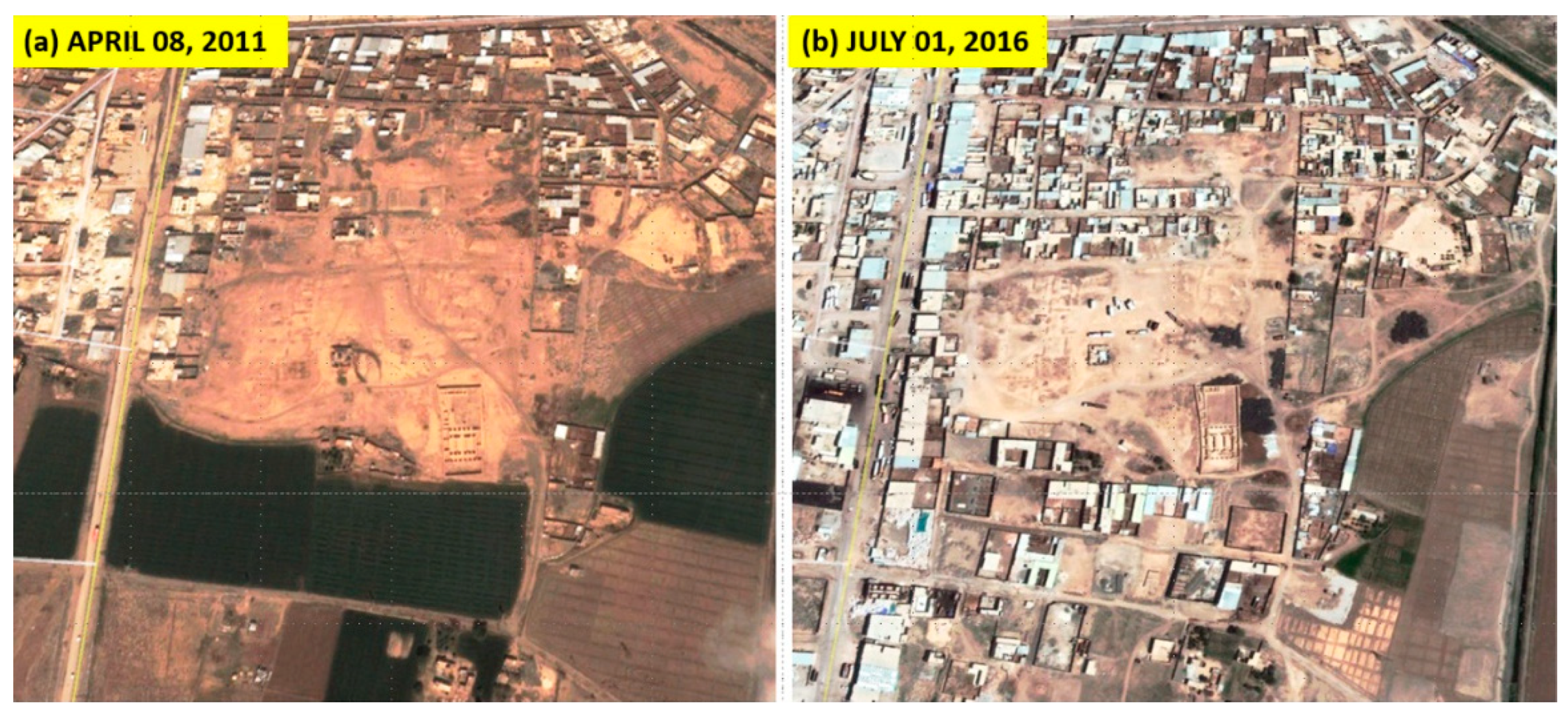
- Casana, J.; Laugier, E.J. Satellite imagery-based monitoring of archaeological site damage in the Syrian civil war. PLoS ONE 2017, 12, e0188589. [Google Scholar] [CrossRef] [Green Version]
- Xu, Y.; Knudby, A.; Côté-Lussier, C. Mapping ambient light at night using field observations and high-resolution remote sensing imagery for studies of urban environments. Build. Environ. 2018, 145, 104–114. [Google Scholar] [CrossRef]
- Do, Q.-T.; Shapiro, J.N.; Elvidge, C.D.; Abdel-Jelil, M.; Ahn, D.P.; Baugh, K.E.; Hansen-Lewis, J.; Zhizhin, M.; Bazilian, M.D. Terrorism, geopolitics, and oil security: Using remote sensing to estimate oil production of the Islamic State. Energy Res. Soc. Sci. 2018, 44, 411–418. [Google Scholar] [CrossRef] [Green Version]
- Benítez, P.C.; McCallum, I.; Obersteiner, M.; Yamagata, Y. Global potential for carbon sequestration: Geographical distribution, country risk and policy implications. Ecol. Econ. 2007, 60, 572–583. [Google Scholar] [CrossRef]
- Hu, Z.D.; Ge, Y.J. Geopolitical Energy Security Evaluation Method and Its Application Based on Politics of Scale. Int. Arch. Photogramm. Remote. Sens. Spat. Inf. Sci. 2013, XL-4/W3, 79–81. [Google Scholar] [CrossRef] [Green Version]
- Moisio, S.; Harle, V. The limits of geopolitical remote sensing. Eurasian Geogr. Econ. 2006, 47, 204–210. [Google Scholar] [CrossRef]
- Colomina, I.; Molina, P. Unmanned aerial systems for photogrammetry and remote sensing: A review. ISPRS J. Photogramm. Remote Sens. 2014, 92, 79–97. [Google Scholar] [CrossRef] [Green Version]
- Antonsich, M. In Defense of “Geopolitical Remote Sensing”: Reply to Moisio and Harle. Eurasian Geogr. Econ. 2006, 47, 211–215. [Google Scholar] [CrossRef] [Green Version]
- Keeley, J.F. The use of commercial satellite imagery and Canadian security needs. In Commercial Satellite Imagery and United Nations Peacekeeping: A View from Above; Keeley, J.F., Huebert, R., Eds.; Ashgate: Aldershot, UK, 2004; pp. 87–98. [Google Scholar]
- Melillos, G.; Themistocleous, K.; Papadavid, G.; Agapiou, A.; Prodromou, M.; Michaelides, S.; Hadjimitsis, D.G. Integrated Use of Field Spectroscopy and Satellite Remote Sensing for Defence and Security Applications in Cyprus; Themistocleous, K., Hadjimitsis, D.G., Michaelides, S., Papadavid, G., Eds.; SPIE: Paphos, Cyprus, 2016; p. 96880F. [Google Scholar]
- Al-Rodhan, N.R.F. Meta-Geopolitics of Outer Space: An Analysis of Space Power, Security and Governance; Palgrave Macmillan: London, UK, 2012; ISBN 978-1-349-33967-9. [Google Scholar]
- Witmer, F.D. Remote sensing of violent conflict: Eyes from above. Int. J. Remote Sens. 2015, 36, 2326–2352. [Google Scholar] [CrossRef]
- Zhang, X.; Xie, J.; Li, C.; Xu, R.; Zhang, Y.; Liu, S.; Wang, J. MEMS-based super-resolution remote sensing system using compressive sensing. Opt. Commun. 2018, 426, 410–417. [Google Scholar] [CrossRef]
- Cantelli, L.; Mangiameli, M.; Melita, C.D.; Muscato, G. UAV/UGV Cooperation for Surveying Operations in Humanitarian Demining. In Proceedings of the 2013 IEEE International Symposium on Safety, Security, and Rescue Robotics (SSRR), Linkoping, Sweden, 21–26 October 2013; IEEE: Linkoping, Sweden; pp. 1–6. [Google Scholar]
- Ibrahim, A.A.; Haruna, A. The united nations and the challenges of global peace, security and development. Res. Humanit. Soc. Sci. 2014, 4. [Google Scholar]
- Satellite Sentinel Project (SSP). Troops in the Demilitarized Zone Confirmation of Violations by Sudan and South Sudan; Satellite Sentinel Project (SSP); Harvard Humanitarian Initiative: Cambridge, MA, USA, 2013; p. 23. [Google Scholar]
- Satellite Sentinel Project (SSP). Radius of Operations: Sudan Increases Air Attack Capacity; Satellite Sentinel Project (SSP); Harvard Humanitarian Initiative: Cambridge, MA, USA, 2011; p. 8. [Google Scholar]
- Som, V. Chinese troops withdraw 2 Km in Galwan Valley, show new satellite images. Indian Express 2020. [Google Scholar]
- Adu-Amanfoh, F. The Roles of Peace and Security, Political Leadership, and Entrepreneurship in the Socio-Economic Development of Emerging Countries: A Compendium of Lessons Learnt from Sub-Saharan Africa; AuthorHouse: Bloomington, IN, USA, 2014; ISBN 978-1-4918-9160-5. [Google Scholar]
- Russell, S. Violence by Fire in East Timor, September 8, 1999; Crimes against Humanity; Yale University: New Haven, CT, USA, 2006; p. 17. [Google Scholar]
- Schimmer, R. Tracking the Genocide in Darfur: Population Displacement as Recorded by Remote Sensing; Yale Center for International and Area Studies New Haven: New Haven, CT, USA, 2008; p. 52. [Google Scholar]
- Marx, A.; Goward, S. Remote sensing in human rights and international humanitarian law monitoring: Concepts and methods. Geogr. Rev. 2013, 103, 100–111. [Google Scholar] [CrossRef]
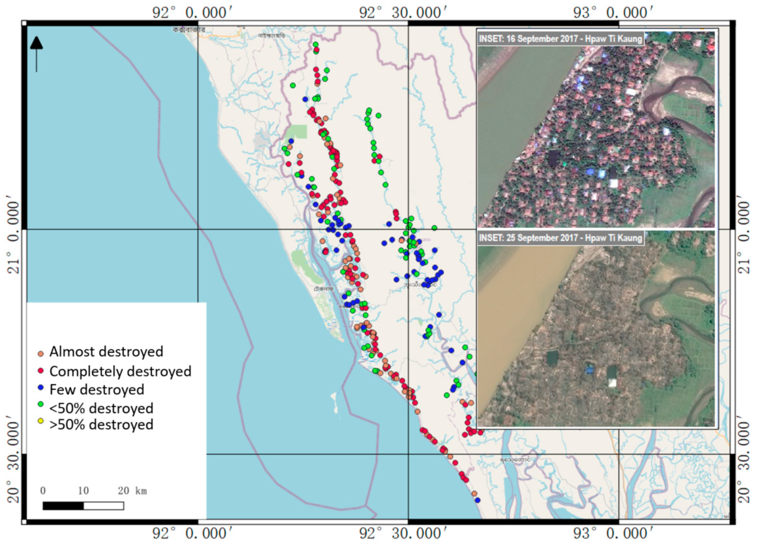
- Marx, A.; Windisch, R.; Kim, J.S. Detecting village burnings with high-cadence smallsats: A case-study in the Rakhine State of Myanmar. Remote. Sens. Appl. Soc. Environ. 2019, 14, 119–125. [Google Scholar] [CrossRef]
- Madden, M.; Ross, A. Genocide and GIScience: Integrating personal narratives and geographic information science to study human rights. Prof. Geogr. 2009, 61, 508–526. [Google Scholar] [CrossRef]
- Schoepfer, E.; Kranz, O.; Addink, E.; Coillie, F. Monitoring natural resources in conflict using an object-based multi-scale image analysis approach. Proc. GEOBIA 2010. [Google Scholar]
- Elvidge, C.D.; Zhizhin, M.; Baugh, K.E.; Hsu, F.-C. Automatic boat identification system for VIIRS low light imaging data. Remote. Sens. 2015, 7, 3020–3036. [Google Scholar] [CrossRef] [Green Version]
- Koch, M.; El-Baz, F. Identifying the effects of the gulf war on the geomorphic features of kuwait by remote sensing and GIS. Photogramm. Eng. Remote Sens. 1998, 64, 739–746. [Google Scholar]
- Yasmi, Y.; Schanz, H. Managing conflict escalation in forestry: Logging versus local community interests in Baru Pelepat village, Sumatra, Indonesia. Int. J. Biodivers. Sci. Ecosyst. Serv. Manag. 2010, 6, 43–51. [Google Scholar] [CrossRef]
- Luo, L.; Wang, X.; Guo, H.; Lasaponara, R.; Shi, P.; Bachagha, N.; Li, L.; Yao, Y.; Masini, N.; Chen, F.; et al. Google Earth as a powerful tool for archaeological and cultural heritage applications: A review. Remote. Sens. 2018, 10, 1558. [Google Scholar] [CrossRef]
- Amnesty International Nigeria. Gruesome Footage Implicates Military in War Crimes. Available online: https://www.amnesty.org/en/latest/news/2014/08/nigeria-gruesome-footage-implicates-military-war-crimes/ (accessed on 19 August 2019).
- Nunez, A.C.N. Admissibility of Remote Sensing Evidence before International and Regional Tribunals; Innovations in Human Rights Monitoring; Amnesty International: New York, NY, USA, 2012. [Google Scholar]
- American Association for the Advancement for Science (AAAS). Geospatial Technologies and Human Rights. Available online: https://www.aaas.org/programs/geospatial-technologies (accessed on 15 August 2019).
- American Association for the Advancement for Science (AAAS). Satellite Imagery and Possible Mass Graves in Sheberghan, Afghanistan; Scientific Responsibility, Human Rights & Law Program; American Association for the Advancement of Science: Washington, DC, USA, 2020. [Google Scholar]
- American Association for the Advancement for Science (AAAS). High-Resolution Satellite Imagery and the Conflict in Eastern Burma; Scientific Responsibility, Human Rights & Law Program; American Association for the Advancement of Science: Washington, DC, USA, 2020. [Google Scholar]
- American Association for the Advancement for Science (AAAS). Geospatial Technologies and Human Rights—North Korea’s Prison Camps Case Study Summary; Scientific Responsibility, Human Rights & Law Program; American Association for the Advancement of Science: Washington, DC, USA, 2020. [Google Scholar]
- American Association for the Advancement for Science (AAAS). Geovisualization for Mapping Human Rights Incidents in Northwestern Pakistan; Scientific Responsibility, Human Rights & Law Program; American Association for the Advancement of Science: Washington, DC, USA, 2020. [Google Scholar]
- Wang, B.Y.; Raymond, N.; Gould, G.; Baker, I. Problems from hell, solution in the heavens?: Identifying obstacles and opportunities for employing geospatial technologies to document and mitigate mass atrocities. Stability: Int. J. Secur. Dev. 2013, 2, 18. [Google Scholar] [CrossRef]
- Satellite Sentinel Project (SSP). Cover-Up: New Evidence of Three Mass Graves in South Kordofan; Harvard Humanitarian Initiative: Cambridge, MA, USA, 2011; p. 10. [Google Scholar]
- Sandalinas, J. Satellite imagery and its use as evidence in the proceedings of the international criminal court. ZLW 2015, 64, 666. [Google Scholar]
- Pavone, I.R. Infectious diseases as a new threat to international peace and security: The security council and the securitization of health. Fachinf. Int. Interdiszip. Rechtsforschung Völkerrechtsblog 2016. [Google Scholar] [CrossRef]
- Dister, S.W.; Beck, L.R.; Wood, B.L.; Falco, R.; Fish, D. The use of GIS and remote sensing technologies in a landscape approach to the study of Lyme disease transmission risk. Proc. GIS 1993, 93, 15–18. [Google Scholar]
- Bhunia, G.S.; Shit, P.K. Introduction to geoinformatics in public health. In Geospatial Analysis of Public Health; Bhunia, G.S., Shit, P.K., Eds.; Springer International Publishing: Cham, Switzerland, 2019; pp. 1–27. ISBN 978-3-030-01680-7. [Google Scholar]
- Beck, L.R.; Rodriguez, M.H.; Dister, S.W.; Rodriguez, A.D.; Rejmankova, E.; Ulloa, A.; Meza, R.A.; Roberts, D.R.; Paris, J.F.; Spanner, M.A.; et al. Remote sensing as a landscape epidemiologic tool to identify villages at high risk for malaria transmission. Am. J. Trop. Med. Hyg. 1994, 51, 271–280. [Google Scholar] [CrossRef] [PubMed]
- Dlamini, S.N.; Beloconi, A.; Mabaso, S.; Vounatsou, P.; Impouma, B.; Fall, I.S. Review of remotely sensed data products for disease mapping and epidemiology. Remote. Sens. Appl. Soc. Environ. 2019, 14, 108–118. [Google Scholar] [CrossRef]
- Kotchi, S.O.; Bouchard, C.; Ludwig, A.; Rees, E.E.; Brazeau, S. Using Earth observation images to inform risk assessment and mapping of climate change-related infectious diseases. Can. Commun. Dis. Rep. 2019, 45, 133–142. [Google Scholar] [CrossRef]
- Avtar, R.; Kumar, P.; Supe, H.; Dou, J.; Sahu, N.; Mishra, B.K.; Yunus, A.P. Did the COVID-19 lockdown-induced hydrological residence time intensify the primary productivity in lakes? Observational results based on satellite remote sensing. Water 2020, 12, 2573. [Google Scholar] [CrossRef]
- Avtar, R.; Herath, S.; Saito, O.; Gera, W.; Singh, G.; Mishra, B.; Takeuchi, K. Application of remote sensing techniques toward the role of traditional water bodies with respect to vegetation conditions. Environ. Dev. Sustain. 2014, 16, 995–1011. [Google Scholar] [CrossRef]
- Caballero-Leiva, I.; Marrero Betancort, N.; Rodriguez Betancor, J.J.; Rodríguez Esparragón, D.; Marcello Ruiz, F.J. An Approximation to the Relationship Between Climatic Variables Obtained Through Remote Satellite Sensors and Hospital Admissions: A Case Study on Gran Canaria Island. Sens. Transducers 2019, 238, 80–86. [Google Scholar]
- Bhunia, G.S.; Shit, P.K. Exploring ecology and associated disease pattern. In Geospatial Analysis of Public Health; Bhunia, G.S., Shit, P.K., Eds.; Springer International Publishing: Cham, Switzerland, 2019; pp. 139–198. ISBN 978-3-030-01680-7. [Google Scholar]
- Racault, M.F.; Abdulaziz, A.; George, G.; Menon, N.; Punathil, M.; McConville, K.; Loveday, B.; Platt, T.; Sathyendranath, S.; Vijayan, V. Environmental reservoirs of vibrio cholerae: Challenges and opportunities for ocean-color remote sensing. Remote Sens. 2019, 11, 2763. [Google Scholar] [CrossRef] [Green Version]
- Beck, L. Remote sensing and human health: New sensors and new opportunities. Emerg. Infect. Dis. 2000, 6, 217–227. [Google Scholar] [CrossRef] [Green Version]
- Igarashi, T.; Kuze, A.; Sobue, S.; Yamamoto, A.; Yamamoto, K.; Oyoshi, K.; Imaoka, K.; Fukuda, T. Japan’s efforts to promote global health using satellite remote sensing data from the Japan Aerospace Exploration Agency for prediction of infectious diseases and air quality. Geospat. Health 2014, 8, 603–610. [Google Scholar] [CrossRef] [Green Version]
- Jamieson, P.D. Lucrative Targets: The U.S. Air Force in the Kuwaiti Theater of Operations; The USAF in the Persian Gulf War; Air Force History and Museums Program: Washington, DC, USA, 2001; ISBN 978-0-16-050958-2. [Google Scholar]
- Marolda, E.J. By Sea, Air, and Land: An Illustrated History of the U.S. Navy and the War in Southeast Asia; Naval Historical Center, Dept. of the Navy: For Sales by Supt. of Docs.; U.S. G.P.O.: Washington, DC, USA, 1994; ISBN 978-0-945274-09-4.
- American Association for the Advancement for Science (AAAS). AAAS, Amnesty Use Geo-Visualization to Shed Light on Human Rights in Pakistan; Scientific Responsibility, Human Rights & Law Program; American Association for the Advancement of Science: Washington, DC, USA, 2010. [Google Scholar]
- Weir, D.; McQuillan, D.; Francis, R.A. Civilian science: The potential of participatory environmental monitoring in areas affected by armed conflicts. Environ. Monit. Assess. 2019, 191, 1–17. [Google Scholar] [CrossRef] [Green Version]
- Letouzé, E.; Meier, P.; Vinck, P. Big Data for Conflict Prevention: New Technology and the Prevention of Violence and Conflict; International Peace Institute: New York, NY, USA, 2013; pp. 4–27. [Google Scholar]
- Wang, Y.; Chen, Q.; Zhu, Q.; Liu, L.; Li, C.; Zheng, D. A survey of mobile laser scanning applications and key techniques over urban areas. Remote Sens. 2019, 11, 1540. [Google Scholar] [CrossRef] [Green Version]
- Rasti, B.; Ghamisi, P. Remote sensing image classification using subspace sensor fusion. Inf. Fusion 2020, 64, 121–130. [Google Scholar] [CrossRef]
- Avtar, R.; Watanabe, T. Unmanned Aerial Vehicle: Applications in Agriculture and Environment; Springer: Berlin/Heidelberg, Germany, 2020. [Google Scholar]
- Bassoli, R.; Sacchi, C.; Granelli, F.; Ashkenazi, I. A Virtualized Border Control System Based on UAVs: Design and Energy Efficiency Considerations. In Proceedings of the 2019 IEEE Aerospace Conference, Big Sky, MT, USA, 2 March 2019; pp. 1–11. [Google Scholar]
- Koslowski, R.; Schulzke, M. Drones Along Borders: Border Security UAVs in the United States and the European Union. Int. Stud. Perspect. 2018, 19, 305–324. [Google Scholar] [CrossRef]
- Abdelzaher, T.; Ayanian, N.; Basar, T.; Diggavi, S.; Diesner, J.; Ganesan, D.; Govindan, R.; Jha, S.; Lepoint, T.; Marlin, B.; et al. Will Distributed Computing Revolutionize Peace? The Emergence of Battlefield IoT. In Proceedings of the 2018 IEEE 38th International Conference on Distributed Computing Systems (ICDCS), Vienna, Austria, 2 July 2018; pp. 1129–1138. [Google Scholar]
- Xiao, L.; Wang, J.; Qiu, X.; Rong, Z.; Zou, X. Dynamic-SLAM: Semantic monocular visual localization and mapping based on deep learning in dynamic environment. Robot. Auton. Syst. 2019, 117, 1–16. [Google Scholar] [CrossRef]
- Cen, R.; Zhang, X.; Tao, Y.; Xue, F.; Zhang, Y. Temporal delay estimation of sparse direct visual inertial odometry for mobile robots. J. Frankl. Inst. 2020, 357, 3893–3906. [Google Scholar] [CrossRef]
- Langford, R.E. Introduction to Weapons of Mass Destruction: Radiological, Chemical, and Biological; Wiley-Interscience: Hoboken, NJ, USA, 2004; ISBN 978-0-471-46560-7. [Google Scholar]
- Rufer, R. Disarmament, Demobilisation and Reintegration (DDR): Conceptual Approaches, Specific Settings, Practical Experiences; Geneva Centre for the Democratic Control of Armed Forces (DCAF): Geneva, Switzerland, 2005; p. 116. [Google Scholar]


| No. | Authors | Publication Year | Study Area | Remote Sensing Sensors | Methodologies |
|---|---|---|---|---|---|
| 1 | Koch and El-Baz, [86] | 1998 | Kuwait | Landsat, SPOT | Visual image interpretation |
| 2 | Bjorgo [43] | 2000 | Thailand | Russian KVR-1000 sensor | Visual image interpretation |
| 3 | Giada et al. [45] | 2003 | Tanzania | IKONOS | Supervised, unsupervised image classification |
| 4 | Schimmer R. [79] | 2006 | East Timor | Landsat | Visual image interpretation |
| 5 | Schimmer R. [80] | 2008 | Darfur, Sudan | MODIS, SPOT-vegetation, Climate data | Temporal change in vegetation phenology |
| 6 | Prins [53] | 2008 | Darfur, Sudan | Landsat ETM+ | Normalized burn ratio (NBR) |
| 7 | Anderson et al. [54] | 2008 | Rift Valley province, Kenya | MODIS | Active fire detection |
| 8 | Madden et al. [83] | 2009 | Uganda | Landsat, Google Earth | Visual interpretation |
| 9 | Schoepfer et al. [84] | 2010 | The Democratic Republic of the Congo | Rapideye, Geoeye-1 | Object-based image classification |
| 10 | Gorsevski et al. [48] | 2012 | South Sudan and Uganda border | Landsat, MODIS, Aerial photographs | Image classification, TCA, disturbance index (DI), NDVI |
| 11 | Hagenlocher et al. [59] | 2012 | Northern Darfur, Sudan | QuickBird | LULC, Object-based image analysis (OBIA) |
| 12 | Marx and Loboda [52] | 2013 | Darfur, Sudan | Landsat | Reflectance, TCA |
| 13 | Jiang et al. [49] | 2017 | Yemen | NPP-VIIRS | Theil-Sen Median Trend Method, Nighttime Light Indexes |
| 14 | Casana et al. [60] | 2017 | Southern Turkey, Syria, and Northern Iraq | High-resolution satellite (DigitalGlobe) | Image interpretation |
| 15 | Pech et al. [28] | 2017 | Goma city, the Democratic Republic of the Congo | Landsat, Worldview-2, topographic maps | Image processing and visual interpretation |
| 16 | Sawalhah et al. [39] | 2018 | Jordan | Landsat 8 | Maximum likelihood classification |
| 17 | Levin et al. [31] | 2018 | Arab countries | VIIRS, Flickr photos | Temporal trends in monthly time-series |
| 18 | Quinn et al. [46] | 2018 | NA | NA | Machine learning |
| 19 | Hassan et al. [47] | 2018 | Bangladesh | Sentinel-2A and Sentinel-2B | Random forest classification |
| 20 | Marx et al. [82] | 2019 | Rakhine, Myanmar | PlanetScope | Pixel-based value extraction |
| 21 | Levin et al. [57] | 2019 | World heritage sites | VIIRS, MODIS, Global Terrorism Database | Statistical analysis |
| 22 | Prem et al. [50] | 2020 | Colombia | Landsat | Empirical model |
| 23 | Shantnawi et al. [30] | 2020 | North Jordan | Landsat | Supervised classification and change analysis |
Publisher’s Note: MDPI stays neutral with regard to jurisdictional claims in published maps and institutional affiliations. |
© 2021 by the authors. Licensee MDPI, Basel, Switzerland. This article is an open access article distributed under the terms and conditions of the Creative Commons Attribution (CC BY) license (http://creativecommons.org/licenses/by/4.0/).
Share and Cite
Avtar, R.; Kouser, A.; Kumar, A.; Singh, D.; Misra, P.; Gupta, A.; Yunus, A.P.; Kumar, P.; Johnson, B.A.; Dasgupta, R.; et al. Remote Sensing for International Peace and Security: Its Role and Implications. Remote Sens. 2021, 13, 439. https://doi.org/10.3390/rs13030439
Avtar R, Kouser A, Kumar A, Singh D, Misra P, Gupta A, Yunus AP, Kumar P, Johnson BA, Dasgupta R, et al. Remote Sensing for International Peace and Security: Its Role and Implications. Remote Sensing. 2021; 13(3):439. https://doi.org/10.3390/rs13030439
Chicago/Turabian StyleAvtar, Ram, Asma Kouser, Ashwani Kumar, Deepak Singh, Prakhar Misra, Ankita Gupta, Ali P. Yunus, Pankaj Kumar, Brian Alan Johnson, Rajarshi Dasgupta, and et al. 2021. "Remote Sensing for International Peace and Security: Its Role and Implications" Remote Sensing 13, no. 3: 439. https://doi.org/10.3390/rs13030439