Article

Investigation of Nighttime Light Pollution in Nanjing, China by Mapping Illuminance from Field Observations and Luojia 1-01 Imagery

School of Remote Sensing and Geomatics Engineering, Nanjing University of Information Science and Technology, Nanjing 210044, China
*
Author to whom correspondence should be addressed.
Sustainability 2020, 12(2), 681; https://doi.org/10.3390/su12020681
Submission received: 13 December 2019 / Revised: 13 January 2020 / Accepted: 15 January 2020 / Published: 17 January 2020

Abstract

:
In recent years, the number of artificial light sources has tremendously increased with the development of lighting technology and the economy. Nighttime light pollution has been an increasing environmental problem, resulting in negative impacts on human health and the ecological environment. Detailed knowledge of light pollution is important for the planning and management of urban lighting. In this study, light pollution in Nanjing, China was monitored and analyzed using field observations and a 130-m resolution Luojia 1-01 nighttime light imagery. Combined with in situ observations and satellite imagery, a variety of empirical models were established for estimating ambient illuminance at night. Cross-validation was employed to assess the performance of these models, indicating that the third-degree polynomials model had the best performance (MAE = 5.06 lx, R2 = 0.81). The developed third-degree polynomial model was then applied to the Luojia 1-01 image to map the nighttime illuminance in Nanjing. The nighttime illuminance depicted the spatial pattern of the light environment over Nanjing and also indicated some heavily light-polluted areas. Some lit areas were residential areas, whose high brightness had negative effects on residents and need particular attention. This study provides a quantitative and objective reference for the light pollution management in Nanjing, and also a reference for light pollution survey in other regions.

1. Introduction

Since the invention of electric lights, a variety of artificial light sources have illuminated the night sky, providing great convenience for the lives and productivity of humans. With the development of lighting technology and the economy, artificial light has continuously increased across the world, both in intensity and extent [1,2,3]. Kyba et al. indicated that Earth’s artificially lit area grew by 2.2% per year during the period of 2012–2016 based on NPP/VIIRS nighttime light remote sensing data [4]. However, artificial lighting has also produced a range of negative environmental consequences, leading to a new environmental problem: light pollution. Light pollution has been “one of the most rapidly increasing problems to change the natural environment” [5].
Studies show that nighttime light pollution has a range of negative effects on human health, including impacts on sleep quality, and increased levels of anxiety, metabolic disorders, asthma, cataracts, and cancer [6,7,8,9,10,11,12]. In addition, artificial lighting changes the naturally dark nighttime environment and has adverse effects on the physiological functions of plants and animals [13,14,15,16].
To improve the nighttime living environment, efforts should be made to reduce urban light pollution. First of all, detailed knowledge of urban light pollution status is needed. However, studies on light pollution monitoring are limited. Several scholars carried out field observations to investigate light pollution. Field observation primarily measures the nighttime brightness using illuminance meters, luminance meters, and digital cameras [17]. The sky quality meter (SQM) manufactured by Unihedron, which has the advantage of low-cost and high sensitivity, is widely used in the in situ observation of light pollution. Kyba et al. [18] used an SQM to observe the night sky brightness in Berlin, Germany and analyzed the effects of cloud cover on urban nighttime light pollution. Hong Kong has built a light pollution observation network consisting of 18 observation sites, each equipped with an SQM for regular monitoring of night sky brightness [19]. Posch et al. [20] monitored the night sky brightness at 26 locations in Eastern Austria with SQMs and examined the variations of night sky brightness. Dobler et al. [21] used digital cameras to take photos on 22 nights at the same location in Manhattan, USA and analyzed the changes of the lightscape in the area. Jin et al. [22] carried out field observations by an HT-8318 lux meter and then map the spatial distribution using GIS spatial interpolation technology. Lim et al. [23] measured light pollution in Seoul, South Korea by observation data gathered from hand-held chromameter and luminance meter. In addition to observations at fixed locations, some researchers have combined observation equipment and GPS to conduct mobile observations. Jechow et al. used all-sky pictures obtained with a camera with fisheye lenses to measure the night sky brightness, and analyzed the impacts of clouds and snow on skyglow [24,25,26]. Compared with SQM, the all-sky camera has the advantages of acquiring hemispheric radiance information and color information. Katz and Levin [27] fixed three SQMs on their bicycles for mobile observations of the night sky brightness along several representative routes in Jerusalem, Israel. Zamorano et al. [28] and Biggs et al. [29] performed mobile observations by SQM in Madrid, Spain and Perth, Australia. Field observations can accurately measure the brightness at point-scale, but cannot provide detailed spatial continuous and full coverage across a city. Considering that nighttime light environment has obvious spatial difference, field observations cannot provide an accurate spatial pattern of urban light pollution.
Nighttime light remote sensing provides an alternative way to monitor light pollution. Defense Meteorological Satellite Program/Operational Linescan System (DMSP/OLS), which can detect faint surface light at night, is used to monitor the spatial distribution nighttime brightness at large scale. Cinzano et al. [30] produced the first World Atlas of the artificial night sky brightness using DMSP/OLS data, showing the extent of light pollution around the world. Bennie et al. [2] used DMSP/OLS data to monitor the spatio-temporal variations of light pollution over Europe during the period of 1995–2010. Other studies on light pollution monitoring based on DMSP/OLS data have been conducted in Italy and Greece [31,32]. The Suomi NPP (National Polar-orbiting Partnership) satellite launched in 2011 carries a new nightlight remote sensor: the Visible Infrared Imaging Radiometer Suite (VIIRS). Compared to DMSP/OLS (5-km spatial resolution, 6-bit radiation resolution), NPP/VIIRS has a higher spatial resolution (750-m) and radiation resolution (14-bit) and is more suitable to monitor nighttime lights [33]. Rybnikova and Portnov [34] studied the relationship between light pollution and the incidence of breast cancer in Israel using DMSP/OLS and NPP/VIIRS data, indicating that NPP/VIIRS showed a significantly higher correlation than DMSP/OLS. Falchi et al. [35] used NPP/VIIRS data to develop a new World Atlas of the artificial night sky brightness. Compared with field observations, satellite remote sensing can provide spatial continuous information on nighttime light pollution. However, the spatial resolution of DMSP/OLS or NPP/VIIRS is not high enough to provide enough spatial detail information and is predominantly used for large-scale research. Some scholars have conducted an aerial observation of nighttime light in Berlin, Germany, Birmingham, England, and the Capital Region of Canada, and obtained fine spatial information of nighttime light environments [36,37,38]. However, aerial remote sensing suffered from high cost, airspace control, and other restricting factors, which greatly limit its practical application. The Luojia 1-01 satellite launched in 2018 provides nighttime light remote sensing images at 130 m resolution, which has the potential of getting more detailed information on light pollution at the urban scale.
Currently, most light pollution studies by field observation and remote sensing primarily measured the night sky brightness as the indicator of nighttime light environment. However, the night sky brightness is not a proper indicator for directly measuring the influence of light pollution on residents. The intensity of light around residences is the most direct factor affecting sleep and health. In addition, the spatial difference of the night sky brightness is relatively small, which cannot fully reflect the spatial distribution of the surface light environment at night. Based on this consideration, this article intends to explore a reasonable and feasible method to monitor nighttime light pollution by combining field observation and Luojia 1-01 remote sensing data.

2. Materials and Methods
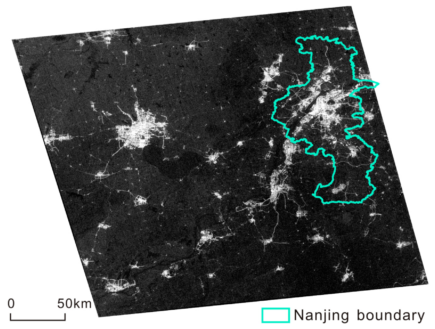
2.1. Study Area

The study area is Nanjing City, the capital of Jiangsu Province, China (Figure 1). It is located in Eastern China (31°14′–32°37′ N and 118°22′–119°14′ E), with a total area of 6587 km2. The resident population of Nanjing in 2018 was 8.34 million, 6.86 million of which were urban residents. Nanjing contains 11 districts: Xuanwu, Qinhuai, Gulou, Jianye, Yuhuatai, Qixia, Pukou, Liuhe, Jiangning, Lishui, and Gaochun. The first six districts are traditional old districts, also known as the “Jiangnan Six Districts.” The latter five districts are known as the “five suburb districts.”
In recent years, Nanjing’s economy has developed rapidly. Its GDP in 2018 amounted to 1.28 trillion Yuan (USD $190.69 billion), ranking 11th of all cities in China. GDP per capita amounted to 153,814 Yuan (USD $22,879), ranking sixth of all cities in China. With the rapid development of economy, urban lighting project was vigorously carried out. However, excessive night lighting in some areas caused serious light pollution problems, sparking media coverage, and protests by residents.

2.2. data

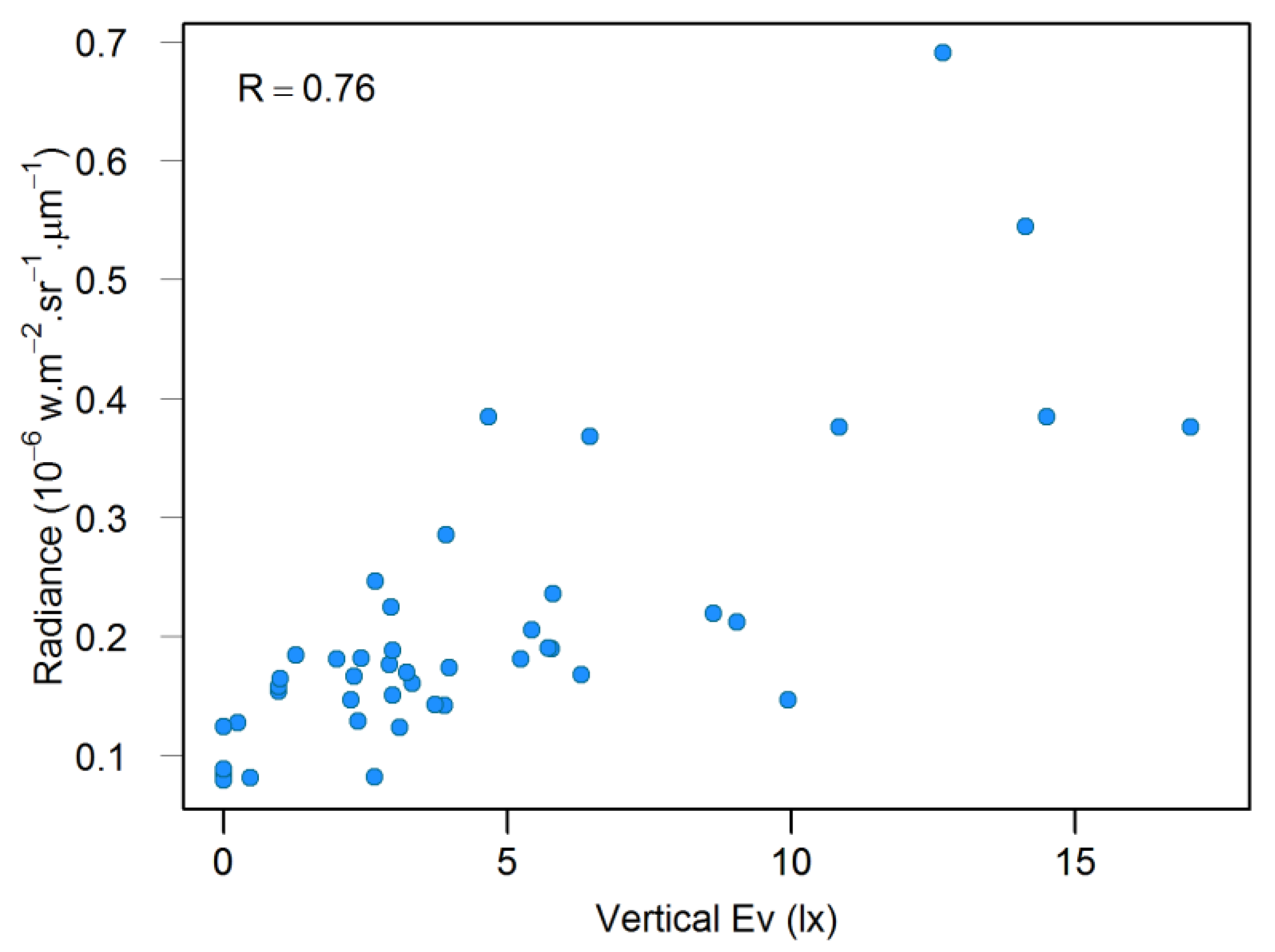
2.2.1. Remote Sensing Data

The Luojia 1-01 remote sensing satellite, developed by Wuhan University, China, was launched on June 2, 2018. It is equipped with a high sensitivity nighttime imaging camera, which can provide nighttime light images at 130-m spatial resolution with a width of 260 km. The spatial resolution of Luojia 1-01 is significantly higher than DMSP/OLS and NPP/VIIRS used in the previous study of light pollution, providing the potential for detailed investigation of urban light pollution.
Luojia 1-01 data can be freely available from the Hubei Data and Application Center of the High-Resolution Earth Observation System (http://www.hbeos.org.cn). The Luojia 1-01 image used in this study is a cloud-free nighttime image acquired at 22:26 (Beijing Time) on 23 November 2018 (Figure 2).
According to the official calibration equation, the Luojia 1-01 image was radiometric calibrated to covert the digital number (DN) value to radiance:
L = DN 3 / 2 · 10 10 ,
where L is the radiance (W·m−2·sr−1·μm−1).
Although the released Luojia 1-01 image was systematically geometric corrected, it still shows obvious geometric errors. Comparing with a Landsat8/OLI image, it can be found that the positioning error of the Luojia 1-01 image was approximately 700 m. The Luojia 1-01 image was then georeferenced by matching road intersections with prominent contours to the Landsat8/OLI image. Based on the selected 49 ground control points, the second-degree polynomial model was applied for registration, achieving an RMS error of 0.58 pixels. Finally, the georeferenced Luojia 1-01 image was clipped and masked according to the Nanjing administrative boundary data.
Luojia 1-01 image can visually show the spatial pattern of lit environment, but it is not suitable to be directly used in light pollution management because it measures the upwelling light from the land surface. Compared with upwelling light, near-surface horizontal light has more direct impacts on residents’ health. In addition, the radiometrically calibrated Luojia 1-01 image that has radiance values (in the unit of W·m−2·sr−1·μm−1) cannot be conveniently used for quantifying ambient brightness level because the commonly-used photometric quantities are illuminance (in the unit of lx) and luminance (in the unit of cd/m2).

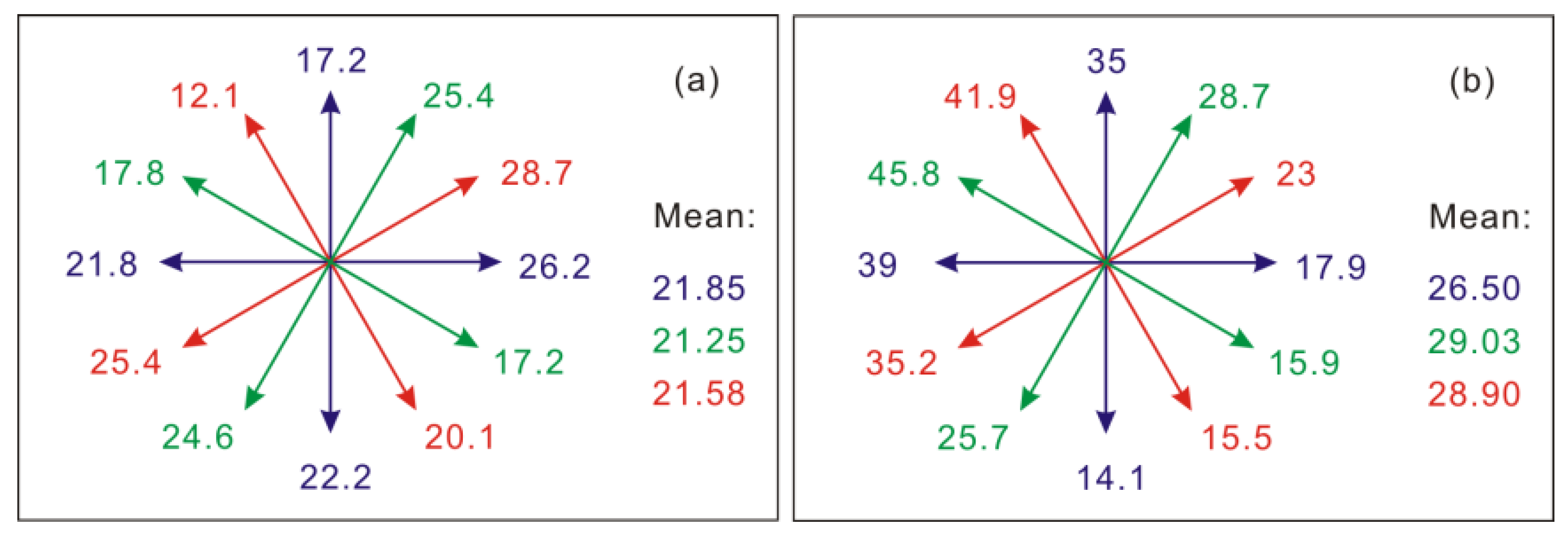
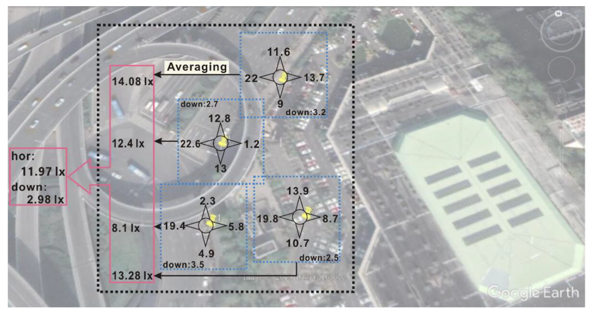
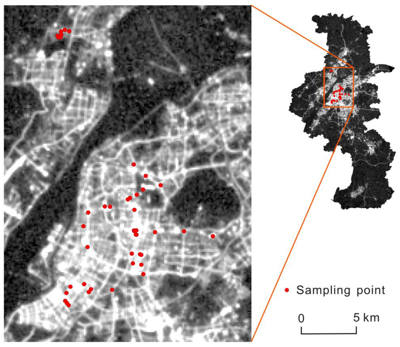
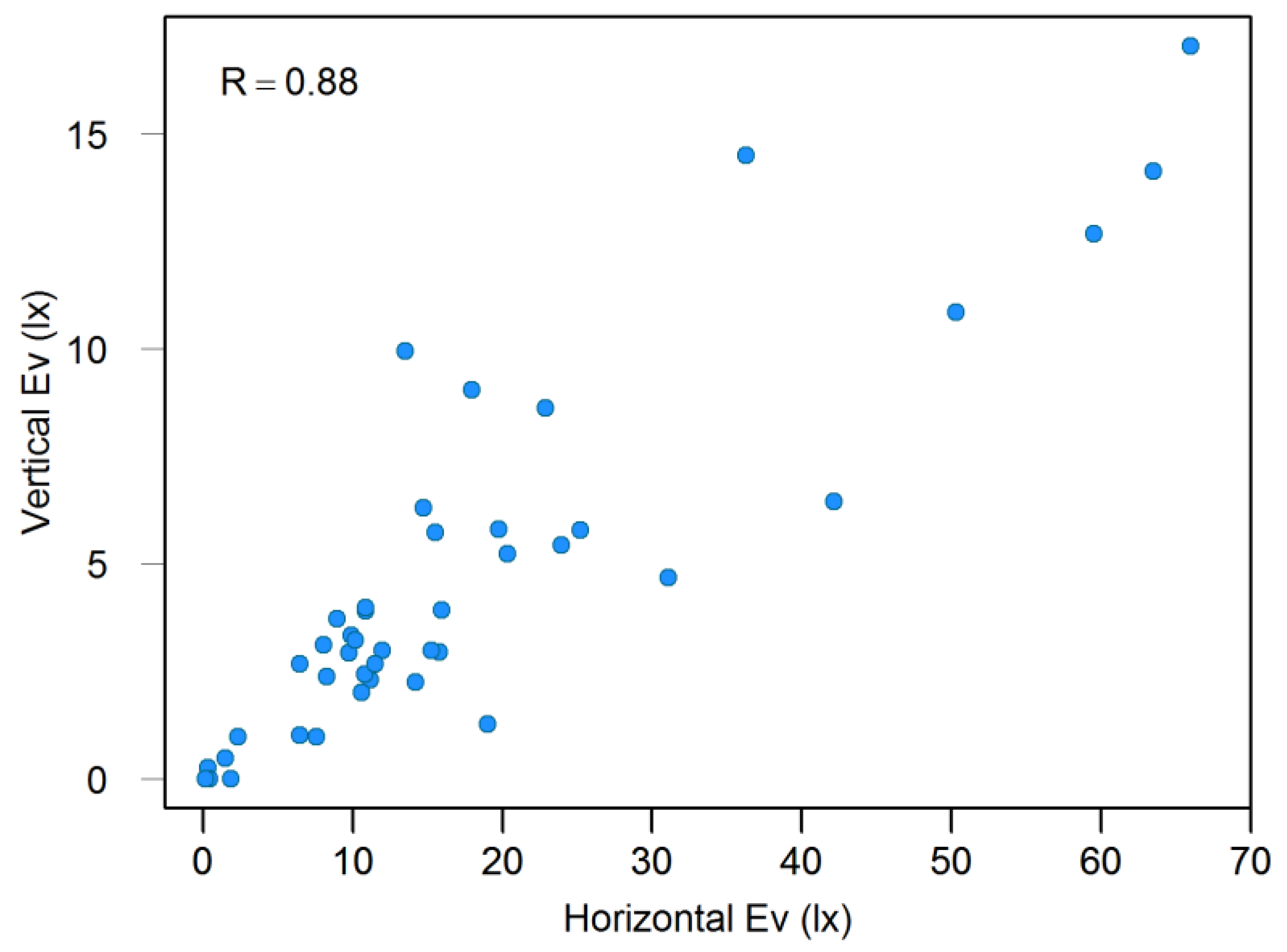
2.2.2. Field Observations
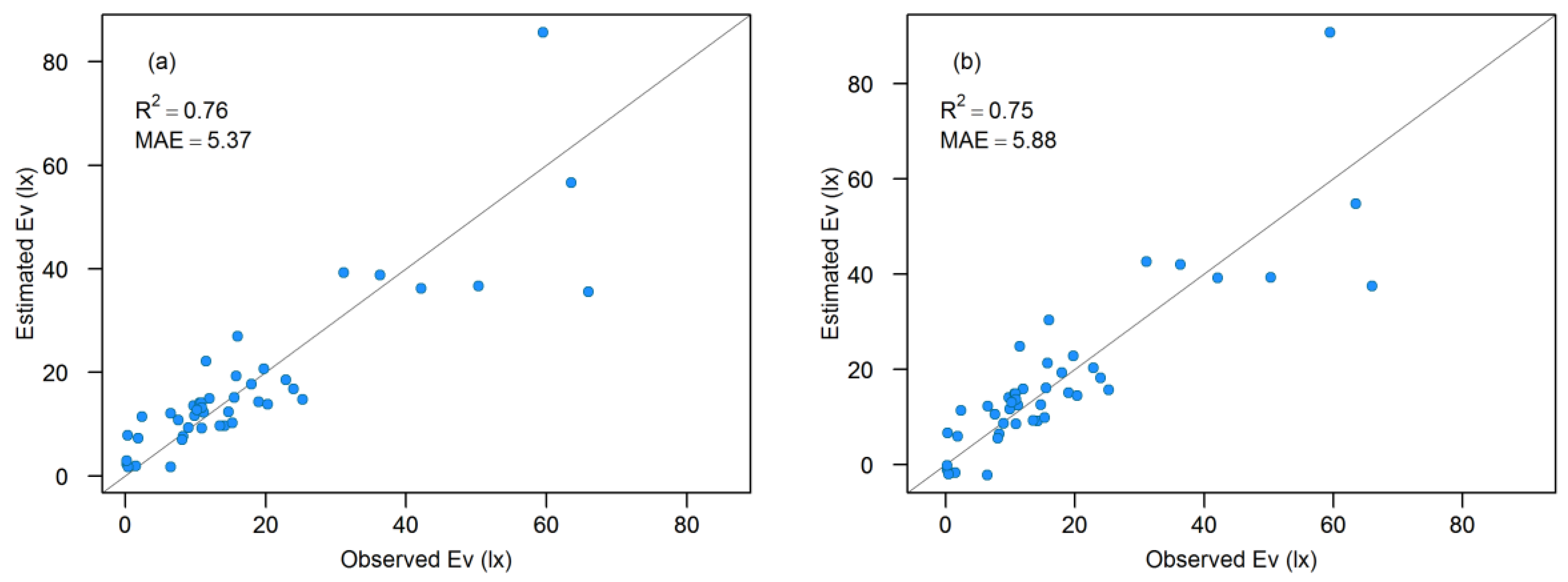
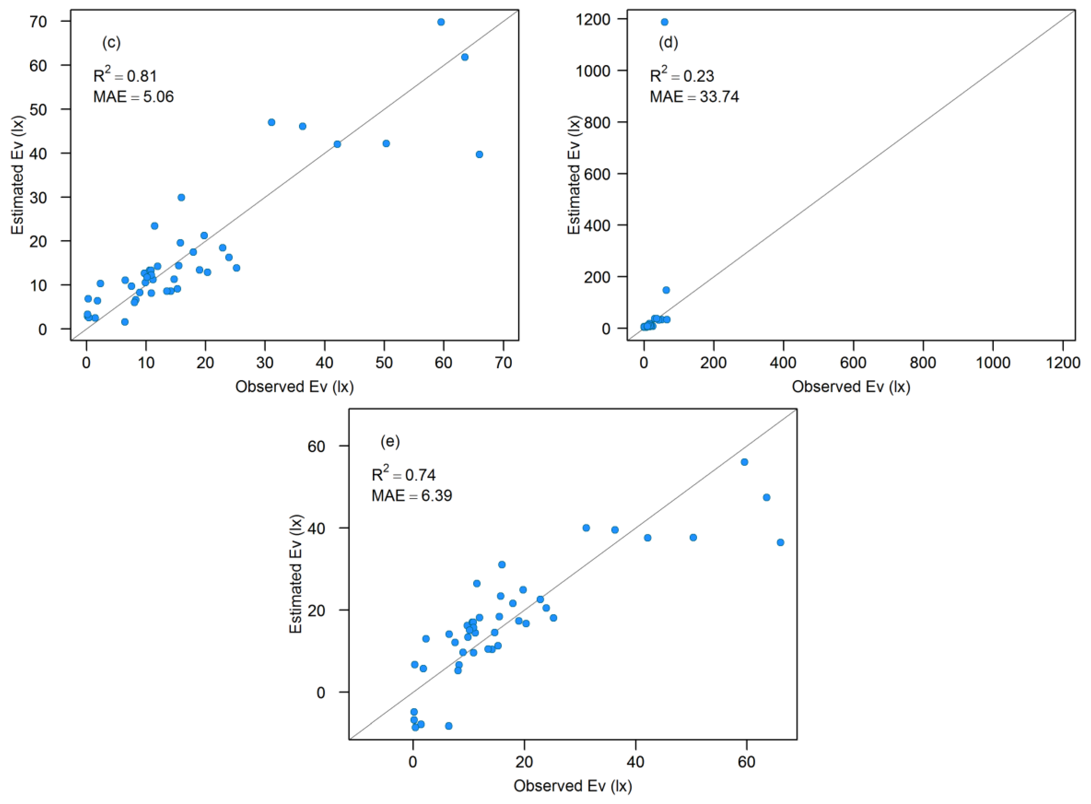
The GM1040 Digital Illuminance Meter manufactured by Benetech was employed in this study to measure illuminance (Ev) in field observations. The instrument measures up to 20,000 lx and the error is ±3% rdg when the Ev is lower than that 10,000 lx. “lx” is the unit of illuminance, which is equal to one lumen per square meter, and “rdg” refers to the reading value of the instrument. GM1040 has a cosine corrector that collects light from a 180° field of view to eliminate the influence of incident angle. It is easy for hand-holding and operating due to its compact size, automatic storage, and data logging functions.
Considering that cloud reflection, absorption, and scattering by water vapor have impacts on the nighttime light environment, field observations were performed on cloudless nights between 17 December 2018, and 13 January 2019. Two areas, including Nanjing downtown and the Nanjing University of Information Science and Technology (NUIST) campus, were selected for observation. Nanjing downtown, located in the middle of Nanjing City, is the largest lit area of the city. NUIST campus, located in the northern suburbs, has a lot of relatively dark areas. Referring to Luojia 1-01 nighttime image and Google Earth high-resolution images, a number of representative locations in these two areas were selected for observation, which covered areas with different brightness levels and lighting conditions.
To coincide with the imaging time of the Luojia 1-01 image, observations were carried out between 9:30 and 11:00 pm (Beijing time). At each observation location, the GM1040 was horizontal-oriented held at the height of 1.8 m to measure horizontal emitted light. The reading of the luxmeter was then recorded as the horizontal-observed Ev. Similarly, the vertical-observed Ev was also recorded at the same height of 1.8 m by measuring upwelling light from the land surface. In addition, pictures were taken to record the sampling environment. Horizontal light is highly variable and shows large directional difference. Though the cosine corrector of the GM1040 can help to reduce the influence of the incident angle, the horizontal-observed Ev in one direction cannot effectively depict the overall brightness level. Under this consideration, the horizontal-observed Ev values of four orthogonal directions (forward, right, backward, left) were all measured at each location. The average Ev of the four horizontal directions was calculated to represent the ambient Ev of the location. To assess the rationality of this scheme, the stability of average horizontal-observed Ev (ambient Ev) was assessed before field observations. Figure 3 shows the test results under two different lighting environments. Figure 3a refers to a location with little difference between different directions, and Figure 3b refers to a location characterized by one particularly bright direction. First, the horizontal-observed illuminations of forward, right, backward, left were measured (blue values), and the mean value was calculated. Then, the measuring directions were rotated 30° degrees clockwise to measure the horizontal-observed illuminations of four new directions (green values) and calculated the mean value. Then the directions were rotated 30° degrees clockwise again to measure the horizontal-observed illuminations of four new directions (red values) and calculated the mean value. From the figure, it can be noted that horizontal-observed Ev showed large directional difference, but the variation was not mutational because of the cosine correction of the luxmeter. A comparison between the average illumination values of the three observations revealed that the average horizontal-observed Ev (ambient Ev) of the four directions at different angles varied little. Therefore, ambient Ev calculated from the horizontal-observed Ev of the four directions of forward, right, backward, and left can well descript the horizontal light environment.
At each observation location, horizontal-observed Ev in the four directions, the downward vertical-observed Ev, and the location coordinates were recorded. In addition, pictures of each location were also taken for later possible use. Considering that the Luojia 1-01 image’s resolution is 130-m, there was still a considerable spatial-scale gap between the single point and the whole pixel. Therefore, additional three points were also observed around each observation location. Then, the average ambient Ev and vertical-observed Ev of the four points was calculated as one observation sample value corresponding to a Luojia 1-01 pixel. Figure 4 shows the observation and calculation process of ambient Ev and vertical-observed Ev of a sample value.
Ambient Ev and vertical-observed Ev values of 204 points were collected during field observations. After the aforementioned processing, 51 samples corresponding to the Luojia 1-01 image pixels were generated.
During the observation, the recorded illumination values may have been affected by some factors: (1) bright vehicle headlights could cause exceedingly high measurements; (2) changing images on large digital billboards could significantly change the environmental illuminance; (3) the inconsistency between the measurement time and satellite overpass could also cause mismatching in Luojia 1-01 image and in-situ observations. To reduce the influence of these factors, these problematic samples were manually flagged and then removed. Finally, 44 samples were retained. Table 1 gives the coordinates and measured illuminance of the 44 samples and Figure 5 shows the spatial distribution of these samples.
Figure 6 shows the scatter plot between ambient Ev and vertical-observed Ev of the 44 samples. The correlation coefficient between ambient Ev and vertical-observed Ev was 0.88, suggesting a strong correlation between them. In general, ambient Ev was obviously higher than vertical-observed Ev, which can be attributed to two main reasons. First, most of the light sources in the city are horizontal light sources, except street lights. Second, vertical-observed Ev measures the light reflected by the ground instead of direct light. It should be noted that the relationship between ambient Ev and vertical-observed Ev is complicated, which is affected by various factors, including the incidence direction of lights, the reflectance, and directionality of the land surface, the wall material of buildings and the distance of buildings. The ambient Ev of some samples was not correlated with vertical-observed Ev, which may be attributed to the reason that different directions and types of light sources led to different relationships between them. For example, a downward-facing street light can produce high vertical-observed Ev and relatively low horizontal-observed Ev, while commercial lighting infrastructures such as billboards and shop windows can produce high horizontal-observed Ev and relatively low vertical-observed Ev. Due to the lack of detailed information, the relationship between the ambient Ev and vertical-observed Ev could not be further analyzed. Though there are various influence factors on the relationship between ambient Ev and vertical-observed Ev, they showed strong correlation because in most cases, bright horizontal lighting leads to the bright land surface and vice versa.

2.3. Method

The vertical-observed Ev values of 44 samples were compared with the radiance values of the corresponding Luojia 1-01 pixels (Figure 7). There is a clear positive correlation (r = 0.76) between the remotely sensed radiance and the vertical-observed Ev. Considering there was also a strong linear correlation between ambient Ev and vertical-observed Ev, it was feasible to estimate the ambient Ev from the Luojia 1-01 data.
It also should be noted that the linear relationship was not very strong, which can be attributed to the spatial scale gap between the point-scale field observation and 130-m Luojia 1-01 pixel. The light environment at night exhibits obvious spatial difference, which varies rapidly with locations, even within a 130m pixel. Calculating the average illuminance to compare with the corresponding pixel value of the Luojia 1-01 image could reduce but not eliminate the influence of the spatial scale gap. In addition, other factors, including the upward-facing lights, shielding effect of the tree canopy, and the multiple reflections of building walls, may also have some impacts on the relationship between field and remote sensing data.
Taking the Luojia 1-01 radiance value as the independent variable and the ambient Ev as the dependent variable, five empirical models (unary linear model, second-degree polynomial model, third-degree polynomial model, exponential model, and logarithmic model) were employed and compared to determinate the optimized estimation algorithm of ambient Ev from Luojia 1-01 image. The equations are as follows:
E v = a · L + b ,
E v = a · L + b · L 2 + c ,
E v = a · L + b · L 2 + c · L 3 + d ,
E v = e a · L + b ,
E v = a · l n ( L ) + b ,
where Ev is ambient Ev (lx), L is the radiance of the pixel (10−6 W·m−2· sr−1·μm−1), and a, b, c, and d are the regression coefficients.
Considering the relatively small sample size, the performance of the five models was evaluated using leave-one-out cross-validation. Each sample in the dataset is used as the test set and the remaining samples used as the training set to fit the model. The established model was then used to predict the test set and generate prediction values of the sample. This process is iterated N times (N is the number of samples) using each sample as the test set once. The mean absolute error (MAE) and the coefficient of determination (R2) were calculated as performance indicators.

3. Result and Discussion

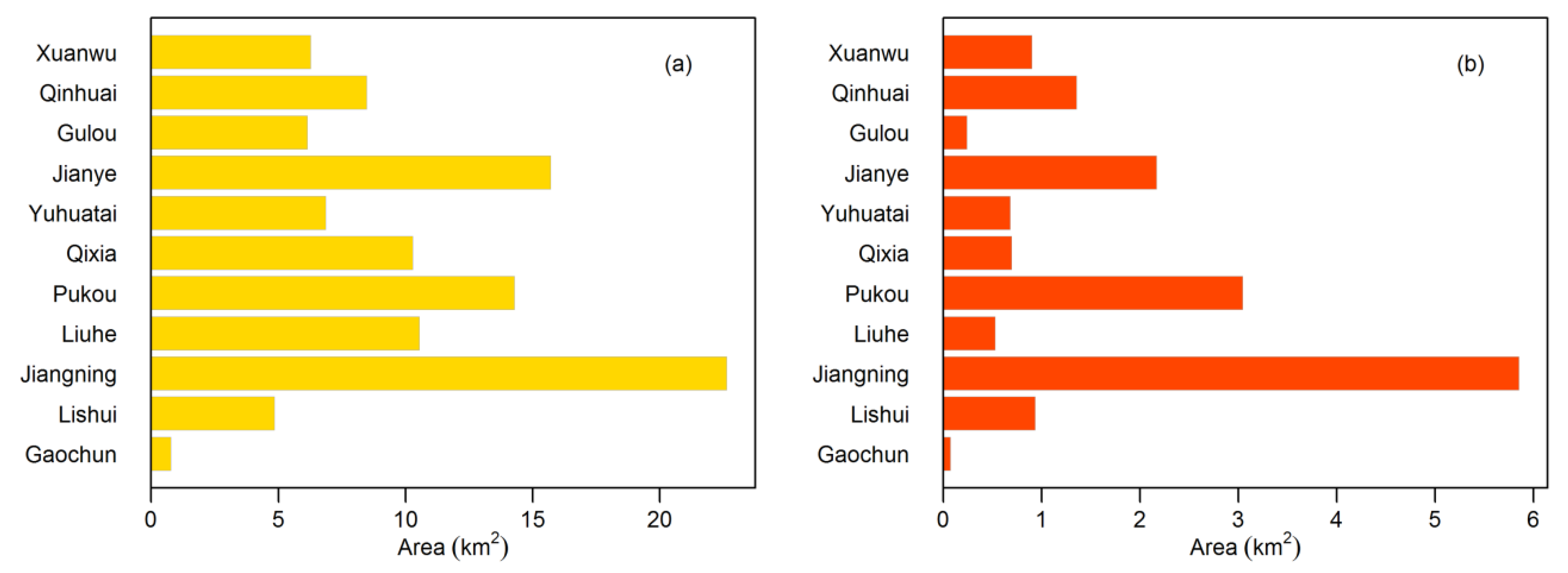
3.1. Mapping Illumination in Nanjing

Figure 8 shows the scatter plots between the measured and estimated ambient Ev of five models. Among the five models, the exponential model performed the worst, with an MAE of 33.73 lx and R2 of 0.23. The model performed well under low and medium light but had serious overestimation under bright lights, which led to low accuracy. The MAE of the remaining four models ranged from 5.06 to 6.39 lx, and the R2 from 0.74 to 0.81. The third-degree polynomial model showed the highest accuracy, with an MAE of 5.06 lx and R2 of 0.81. As shown in the scatterplot of this model (Figure 8c), most of the samples were distributed near the 1:1 line, with no obvious overestimation or underestimation.
Based on the evaluation results, the third-degree polynomial model was selected to estimate ambient Ev from Luojia 1-01 data. Formula 7 provides the model equation:
E v = 1.49 · L + 528.396 · L 2 582.857 · L 3 0.993 ,
where Ev is ambient Ev (lx), L is the radiance of the pixel (10−6 W·m−2·sr−1·μm−1).
The generated third-degree polynomial model was applied to the Luojia 1-01 radiance image, and the nighttime ambient Ev in Nanjing was mapped (Figure 9).

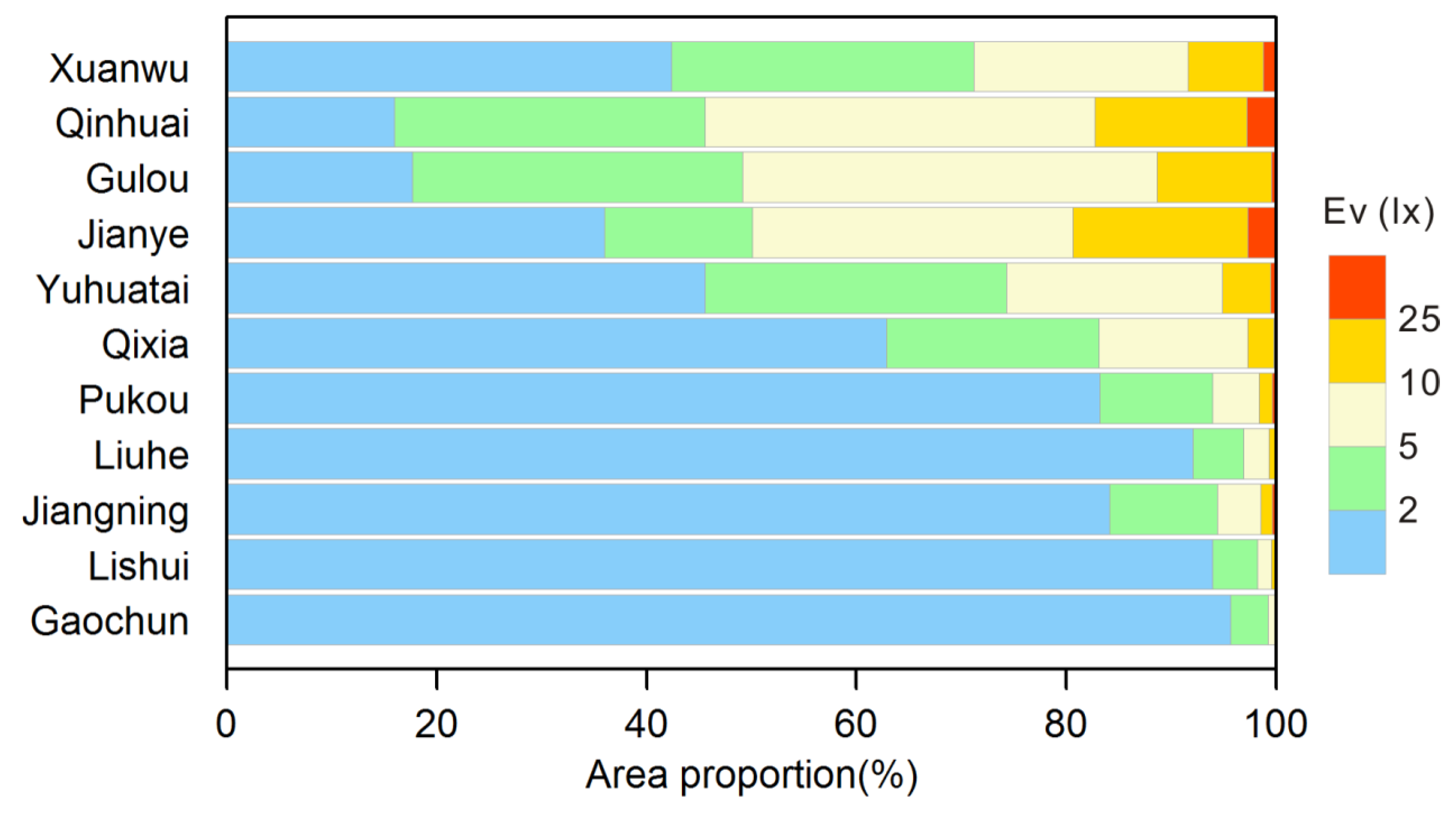
3.2. Spatial Pattern of Light Pollution over Nanjing

Figure 9 shows obvious spatial differences in the nighttime light environment over Nanjing. The ambient Ev in most suburban areas was generally less than 1 lx, whereas some urban districts had very high Ev values (>50 lx). The largest and brightest area located in the main district of Nanjing. This outstanding lit area covered old districts such as Xuanwu, Gulou, Jianye, Qinhuai, and Yuhuatai Districts, and also spread eastward to the Xianlin Area of Qixia District and southward to the Jiulong Lake Area in Jiangning District. Pukou and Liuhe Districts on the north bank of the Yangtze River also featured a second largest bright area in Nanjing. Two relatively smaller isolated lit areas in southern Nanjing were the core area of Gaochun and Lishui Districts.
Based on the administrative boundary data, the light pollution status of the 11 districts was analyzed. Figure 10 shows the areas with Ev greater than 10 lx and 25 lx in each district. Jiangning District had the largest area with Ev greater than 10 lx (22.63 km2), followed by Jianye, Pukou, Liuhe, and Qixia Districts, whose areas with Ev greater than 10 lx were 15.72, 14.28, 10.55, and 10.29 km2 respectively. Gaochun District has the smallest area with Ev greater than 10 lx, which was only 0.76 km2. Jiangning District also had the largest area with Ev greater than 25 lx, reaching 5.85 km2, followed by Pukou and Jianye Districts (3.04 and 2.16 km2, respectively). Gaochun District also had the smallest area with Ev greater than 25 lx (0.07 km2). Jiangning is the region with the largest population and highest total GDP in Nanjing, which has a large built-up area, large transportation hubs such as Lukou International Airport and Nanjing South Railway Station. However, Gaochun is the furthest from the downtown of Nanjing. Although the area is large, the population is relatively small (0.45 million) and the economy is less developed, resulting in a much smaller bright area than the other districts.
Referring to the CIE Guide on the limitation of the effects of obtrusive light from outdoor lighting installations [39] and the Chinese Code for lighting design of urban nightscape [40], the ambient Ev of Nanjing was divided into five levels: very dark (<2 lx), dark (2–5 lx), moderate (5–10 lx), bright (10–25 lx), and very bright (>25 lx). The area proportions of different Ev levels in 11 districts were given in Figure 11. Qinhuai, Gulou, Jianye, Xuanwu, Yuhuatai, and Qixia Districts had low proportions of dark areas. In particular, in the Qinhuai and Gulou Districts, the proportions of the very dark areas were less than 20%. Among Qinhuai, Jianye, and Xuanwu, the area proportions of the very dark areas were also relatively low (<50%). Characterized by small areas, dense population and long development history, these old districts exhibited overall high brightness. As a contrast, the suburban districts of Pukou, Jiangning, Liuhe, Lishui, and Gaochun exhibited high proportions of the very dark areas that were higher than 80%. Although Jiangning and Pukou had large bright areas (shown in Figure 10), these districts are much larger than old districts, resulting in relatively low proportions of bright areas.
According to the nighttime ambient Ev map of Nanjing, the regions with extensive high luminance and large extent were identified as heavily light-polluted regions. These regions can be classified into several categories: large transportation hubs, such as Lukou International Airport and Nanjing South Railway Station; large shopping areas, including Xinjiekou, Confucius Temple, and Tianyin Square; residential areas, including Xianlin Lake, Cuipingchengyuan, the Youth Olympic Village, and Heding Bridge; roads, including Pukou Avenue, Jiangbei Expressway, and Tianyuan East Road; large factories, including Sinopec Yangzi Petrochemical and Nanjing Steel factories.
Table 2 showed the nighttime Ev maps and corresponding Google Earth’s high-resolution satellite images of some typical heavily light-polluted regions. Lukou International Airport is one of the important aviation hubs in China. Though the Ev over the terminals and warehouse areas were mostly higher than 25 lx, the surrounding area was very dark. In addition, there were fewer residential buildings around the airport. Therefore, the high illuminance of the airport had little impact on the residents. As the busiest commercial area of Nanjing, Xinjiekou is very bright at night. The overall Ev was above 25 lx, and some areas reached higher Ev than 50 lx. Although the area is a commercial area, there are still many old residential buildings that can be seen from the Google Earth image. An overly bright nighttime light environment can have an impact on the residents in the area. Xianlin Lake area is a newly developed residential area in the eastern suburbs of Nanjing, which is dominated by new high buildings and has a large shopping mall. From the nighttime Ev map, the overall Ev of the region is shown to be high (>20 lx), and some areas reached a higher level than 30 lx. Given the dense population in this area, the light pollution was severe and needed special attention. Pukou Avenue is a newly constructed traffic artery. There are many landscape lights on both sides of the road, causing an extremely bright environment at night (Ev > 50 lx). From the Google Earth image, it can be seen that several residential buildings are under construction on the roadside, future residents will certainly be affected by the high illuminance. Sinopec Yangzi Petrochemical, a large petrochemical plant in Nanjing, has a very large factory campus. Some areas on the campus were relatively bright, with Ev ranged from 10 to 30 lx. Considering that there are few residential buildings around the plant, the influence of light pollution was relatively small.

3.3. Discussion

Monitoring nighttime light pollution is a challenging task due to the directivity and high spatial variability of lights. Previous studies primarily observed or estimated night sky brightness as the indicator of light pollution. However, this study mapped ambient Ev to quantify light pollution in Nanjing City. Compared to sky brightness, ambient Ev can better describe the surface light environment and thus more closely correlates to residents’ health. To generate a reliable nighttime Ev map, special measurement and processing were carried out in field observations. This was the first time that 130-m resolution Luojia 1-01 nighttime image was used to quantitatively investigate urban light pollution. The generated high-resolution Ev map represented the detailed spatial pattern of the light environment in Nanjing and identified the heavily light-polluted areas. This is an interesting and meaningful attempt for monitoring and analyzing urban light pollution at night.
There were some limitations in this study. The sample size for Ev estimation was relatively small for empirical modeling, which to a certain extent affected the stability of the empirical models. There were two main reasons that caused the limited sample size. First, in view of the evident temporal changes of artificial lighting, field observations were only performed around the Luojia 1-01 overpass time to match the satellite image as closely as possible. Second, to avoid shadowing by pedestrians and vehicle headlights as much as possible, the observations had to be made on foot. Due to the restricted observation time and slow speed of walking and measuring, the volume of obtained samples was relatively small. Ideally, more observers are required to conduct measurement synchronously at different locations to collect adequate observation data. During the in situ observation, it was noted that some lamps (primarily landscape lights) installed on building rooftops emitted light upward. The satellite sensor could receive high levels of radiation and lead to high estimated Ev for these locations with upward-facing lights, but ambient Ev on the ground may not be high. The possible solution way is to conduct field observations in areas with high Ev and manually identify these discrepancies. On the other hand, these bright upward-facing lights are inappropriate, which cause high sky brightness and significant power waste but do not provide effective lighting for residents. The combination of field and satellite observations can identify these upward-facing light sources and provide targeted information for nighttime light pollution remediation. Though Luojia 1-01 provides much better spatial resolution (130 m) than DMSP/OLS and NPP/VIIRS, there is still a relatively large spatial-scale difference between Luojia 1-01 pixel and point-scale observation. Within one 130-m pixel, the nighttime lighting environment has obvious spatial heterogeneity. This study used the average horizontal-observed Ev of four different points within one area to correspond with the pixels of the Luojia 1-01 image, which reduced the impact of the spatial gap to some degree, but there were still some negative influences. It also should be mentioned that the GM1040 illuminance meter used in field observation is not very sensitive in the dark environment. However, this limitation of the luxmeter should have negligible effects in this study because urban light pollution mainly focuses on lit areas. Despite the low sensitivity for low brightness level, the luxmeter has some advantages for observing light pollution, including its low price, high convenience and cosine compensation.
The derived ambient Ev map provides a useful reference to assess the light-contamination conditions of Nanjing City. On the whole, the light pollution in this city is quite serious. Ambient Ev in urban areas was generally higher than 5 lx. Some heavily light-polluted regions showed not only extensive high luminance but also large extents. Among these heavily light-polluted regions, some were residential areas or mixed commercial and residential areas. Considering that most residents have fallen asleep before 10:30 pm (the Luojia 1-01 overpass time), the residents in these areas are suffered from serious light pollution, which has negative impacts on their sleep and health. Effective light environment planning and light pollution control measures are required to produce better lit environments for residents.

4. Conclusions

This study used field observations and Luojia 1-01 data to monitor the light pollution in Nanjing City. During the field observations, the mean ambient Ev of four directions was calculated as the indicator of horizontal-observed illuminance at a point. Then the ambient Ev of four neighboring points in a specified range was averaged to match the Luojia 1-01 130-m pixel, bridging the spatial gap between the field and satellite observations. Five empirical models were employed to estimate ambient Ev from the Luojia 1-01 image. Cross-validation results suggested that the third-degree polynomial model outperformed the others with the lowest MAE of 5.06 lx and the highest R2 of 0.81. This model was then selected to produce a nighttime ambient Ev map, depicting the spatial distribution details of nighttime light pollution in Nanjing. Nanjing showed obvious spatial difference in the nighttime light environment. Some areas exhibited very high ambient Ev (> 50 lx). These lit areas included large transportation hubs, large shopping areas, some residential areas, roads, and large factories. Transportation hubs and large factories had relatively small light impacts on residents because there were few residents in the surrounding areas. The other lit areas all had larger populations so that the bright light environments at night can have negative impacts on residents. These heavily light-polluted areas need special attention and effective preventive measures.
Luojia 1-01 provides free nighttime images with a much higher resolution compared to DMSP/OLS and NPP/VIIRS, which is a valuable satellite data source for light pollution survey. This study explored the potential of qualifying urban nighttime light pollution using the Luojia 1-01 data and field observations. The method does not aim to deliver high accuracy but could provide a useful estimate of ambient illuminance derived from satellite data and it is simple and easy to reproduce. The produced Ev map provided a quantitative and objective reference for urban nighttime lighting pollution management. It is also helpful for residents to better understand light pollution situations. The details of observation, processing, and modeling described also provide a reference for light pollution investigation in other regions.
In future work, some efforts could be considered to improve the estimation of ambient Ev. (1) More data points across several cities should be collected to test the model performances for different situations. (2) Taking the average from temporal sampling is helpful to reduce the influence of interference factors during observations to collect higher-quality observation data. (3) More sensitive luxmeters that have higher accuracy in dark environments can be employed to span larger brightness ranges, especially for darker places. (4) High-resolution nighttime images collected by a drone are advised, which may help to bridge the spatial-scale gap between observation and Luojia 1-01 remote sensing data. (5) All-sky cameras that measure hemispheric radiance information and color information can be used to provide additional information. (6) The mismatch between the spectral response of the Luojia 1-01 sensor and the photopic response of the luxmeter should be considered. Though at this stage Luojia 1-01 and other nighttime satellite sensors do not provide multi-spectral data, empirical correct functions can be developed and applied to remote sensing images to better match the photopic response. (7) With abundant samples and additional ancillary information (light sources, land surface reflectance, building locations, reflectance of building wall, etc.), physical models could be developed to describe the relationship between upwelling radiance and downwelling illuminance. These physical models can also be compared with empirical models. 8) Given that the relationship between field and remote sensing data may vary under different lighting conditions, developing different models for different environmental conditions respectively may achieve better performance with enough spatial ancillary data. Machine learning technology that can effectively capture complicated relationships is also expected to improve the estimation accuracy of ambient Ev.

Author Contributions

Conceptualization, Y.X; methodology, Y.X.; formal analysis, J.L., Y.X., and W.C.; investigation, J.L., W.C., M.J., B.S., Y.W., and J.W.; writing—original draft preparation, J.L. and Y.X.; writing—review and editing, J.L., Y.X., W.C., M.J., B.S. Y.W., and J.W.; supervision, Y.X.; project administration, Y.X. All authors have read and agreed to the published version of the manuscript.

Funding

This research was funded by the College Students’ Enterprise and Entrepreneurship Education Program of NUIST (grant number 201910300115Y), the Humanities and Social Sciences Foundation of the Ministry of Education of China (grant number 17YJCZH205), the Environmental Monitoring Foundation of Jiangsu Province (grant number 1903), the National Key Research and Development Program of China (2017YFB0503903-4), and Qing Lan Project of Jiangsu Province (grant number R2019Q03).

Acknowledgments

The authors would like to thank the Hubei Data and Application Center of the High-Resolution Earth Observation System for providing Luojia 1-01 data. We also thank the three reviewers for their valuable comments and suggestions.

Conflicts of Interest

The authors declare no conflict of interest.

References

  1. Longcore, T.; Rich, C. Ecological light pollution. Front. Ecol. Environ. 2004, 2, 191–198. [Google Scholar] [CrossRef]
  2. Bennie, J.; Davies, T.W.; Duffy, J.P.; Inger, R.; Gaston, K.J. Contrasting trends in light pollution across Europe based on satellite observed night time lights. Sci. Rep. 2014, 4, 3789. [Google Scholar] [CrossRef] [Green Version]
  3. Xiang, W.; Tan, M. Changes in Light Pollution and the Causing Factors in China’s Protected Areas, 1992–2012. Remote Sens. 2017, 9, 1026. [Google Scholar] [CrossRef] [Green Version]
  4. Kyba, C.C.; Kuester, T.; De Miguel, A.S.; Baugh, K.; Jechow, A.; Hölker, F.; Bennie, J.; Elvidge, C.D.; Gaston, K.J.; Guanter, L. Artificially lit surface of Earth at night increasing in radiance and extent. Sci. Adv. 2017, 3, e1701528. [Google Scholar] [CrossRef] [Green Version]
  5. Gallaway, T.; Olsen, R.N.; Mitchell, D.M. The Economics of Global Light Pollution. Ecol. Econ. 2010, 69, 658–665. [Google Scholar] [CrossRef]
  6. Bephage, G. Promoting quality sleep in older people: The nursing care role. Br. J. Nurs. 2005, 14, 205–210. [Google Scholar] [CrossRef]
  7. Hölker, F.; Wolter, C.; Perkin, E.K.; Tockner, K. Light pollution as a biodiversity threat. Trends Ecol. Evol. 2010, 25, 681–682. [Google Scholar] [CrossRef]
  8. Lin, R.S.; Sung, F.C.; Huang, S.L.; Gou, Y.L.; Ko, Y.C.; Gou, H.W.; Shaw, C.K. Role of urbanization and air pollution in adolescent asthma: A mass screening in Taiwan. J. Formos. Med. Assoc. 2001, 100, 649–655. [Google Scholar] [CrossRef] [PubMed]
  9. Pauley, S.M. Lighting for the human circadian clock: Recent research indicates that lighting has become a public health issue. Med. Hypotheses 2004, 63, 588–596. [Google Scholar] [CrossRef] [PubMed] [Green Version]
  10. Kohyama, J. A newly proposed disease condition produced by light exposure during night: Asynchronization. Brain Dev. 2009, 31, 255–273. [Google Scholar] [CrossRef] [PubMed]
  11. Stevens, R.G. Light-at-night, circadian disruption and breast cancer: Assessment of existing evidence. Int. J. Epidemiol. 2009, 38, 963–970. [Google Scholar] [CrossRef] [PubMed]
  12. Bedrosian, T.A.; Nelson, R.J. Influence of the modern light environment on mood. Mol. Psychiatry 2013, 18, 751–757. [Google Scholar] [CrossRef] [PubMed]
  13. Bennie, J.; Davies, T.W.; Cruse, D.; Gaston, K.J. Ecological effects of artificial light at night on wild plants. J. Ecol. 2016, 104, 611–620. [Google Scholar] [CrossRef] [Green Version]
  14. Kempenaers, B.; Borgström, P.; Loës, P.; Schlicht, E.; Valcu, M. Artificial night lighting affects dawn song, extra-pair siring success, and lay date in songbirds. Curr. Biol. 2010, 20, 1735–1739. [Google Scholar] [CrossRef] [PubMed] [Green Version]
  15. Van Doren, B.M.; Horton, K.G.; Dokter, A.M.; Klinck, H.; Elbin, S.B.; Farnsworth, A. High-intensity urban light installation dramatically alters nocturnal bird migration. Proc. Natl. Acad. Sci. USA 2017, 114, 11175–11180. [Google Scholar] [CrossRef] [PubMed] [Green Version]
  16. Kamrowski, R.L.; Limpus, C.; Moloney, J.; Hamann, M. Coastal light pollution and marine turtles: Assessing the magnitude of the problem. Endanger. Species Res. 2012, 19, 85–98. [Google Scholar] [CrossRef] [Green Version]
  17. Hänel, A.; Posch, T.; Ribas, S.J.; Aubé, M.; Duriscoe, D.; Jechow, A.; Kollath, Z.; Lolkerna, D.E.; Moore, C.; Schmidt, N.; et al. Measuring night sky brightness, methods and challenges. J. Quant. Spectrosc. Radiat. Transf. 2018, 205, 278–290. [Google Scholar] [CrossRef] [Green Version]
  18. Kyba, C.C.M.; Ruhtz, T.; Fischer, J.; Hölker, F. Cloud Coverage Acts as an Amplifier for Ecological Light Pollution in Urban Ecosystems. PLoS ONE 2011, 6, e17307. [Google Scholar] [CrossRef] [Green Version]
  19. Pun, C.S.J.; So, C.W.; Leung, W.Y.; Wong, C.F. Contributions of artificial lighting sources on light pollution in Hong Kong measured through a night sky brightness monitoring network. J. Quant. Spectrosc. Radiat. Transf. 2014, 139, 90–108. [Google Scholar] [CrossRef] [Green Version]
  20. Posch, T.; Blinder, F.; Puschnig, J. Systematic measurements of the night sky brightness at 26 locations in Eastern Austria. J. Quant. Spectrosc. Radiat. Transf. 2018, 211, 144–165. [Google Scholar] [CrossRef] [Green Version]
  21. Dobler, G.; Ghandehari, M.; Koonin, S.E.; Nazari, R.; Patrinos, A.; Sharma, M.S.; Tafvizi, A.; Vo, H.T.; Wurtele, J.S. Dynamics of the urban lightscape. Inform. Syst. 2015, 54, 115–126. [Google Scholar] [CrossRef] [Green Version]
  22. Jin, X.; Li, Y.; Zhang, J.; Zheng, J.; Liu, H. An Approach to Evaluating Light Pollution in Residential Zones: A Case Study of Beijing. Sustainability 2017, 9, 652. [Google Scholar] [CrossRef] [Green Version]
  23. Lim, H.S.; Ngarambe, J.N.; Kim, J.T.; Kim, G. The Reality of Light Pollution: A Field Survey for the Determination of Lighting Environmental Management Zones in South Korea. Sustainability 2018, 10, 374. [Google Scholar] [CrossRef] [Green Version]
  24. Jechow, A.; Kolláth, Z.; Ribas, S.J.; Spoelstra, H.; Hölker, F.; Kyba, C.C. Imaging and mapping the impact of clouds on skyglow with all-sky photometry. Sci. Rep. 2017, 7, 6741. [Google Scholar] [CrossRef] [PubMed]
  25. Jechow, A.; Hölker, F. Snowglow—The Amplification of skyglow by snow and clouds can exceed full moon illuminance in suburban areas. J. Imaging 2019, 5, 69. [Google Scholar] [CrossRef] [Green Version]
  26. Jechow, A.; Hölker, F.; Kyba, C.C. Using all-sky differential photometry to investigate how nocturnal clouds darken the night sky in rural areas. Sci. Rep. 2019, 9, 1391. [Google Scholar] [CrossRef] [Green Version]
  27. Katz, Y.; Levin, N. Quantifying urban light pollution—A comparison between field measurements and EROS-B imagery. Remote Sens. Environ 2016, 177, 65–77. [Google Scholar] [CrossRef]
  28. Zamorano, J.; de Miguel, A.S.; Ocaña, F.; Pila-Diez, B.; Castaño, J.G.; Pascual, S.; Tapia, C.; Gallego, J.; Fernandez, A.; Nievas, M. Testing sky brightness models against radial dependency: A dense two dimensional survey around the city of Madrid, Spain. J. Quant. Spectrosc. Radiat. Transf. 2016, 181, 52–66. [Google Scholar] [CrossRef] [Green Version]
  29. Biggs, J.D.; Fouché, T.; Bilki, F.; Zadnik, M.G. Measuring and mapping the night sky brightness of Perth, Western Australia. Mon. Not. R. Astron. Soc. 2012, 421, 1450–1464. [Google Scholar] [CrossRef] [Green Version]
  30. Cinzano, P.; Falchi, F.; Elvidge, C.D. The first world atlas of the artificial night sky brightness. Mon. Not. R. Astron. Soc. 2001, 328, 689–707. [Google Scholar] [CrossRef] [Green Version]
  31. Chalkias, C.; Petrakis, M.; Psiloglou, B.; Lianou, M. Modelling of light pollution in suburban areas using remotely sensed imagery and GIS. J. Environ. Manag. 2006, 79, 57–63. [Google Scholar] [CrossRef] [PubMed]
  32. Cinzano, P.; Falchi, F.; Elvidge, C.D.; Baugh, K.E. Mapping the artificial sky brightness in Europe from DMSP satellite measurements: The situation of the night sky in Italy in the last quarter of century. arXiv 1999, arXiv:astro-ph/9905340. [Google Scholar]
  33. Elvidge, C.D.; Baugh, K.E.; Zhizhin, M.; Hsu, F.C. Why VIIRS data are superior to DMSP for mapping nighttime lights. Proc. Asia-Pac. Adv. Netw. 2013, 35, 62. [Google Scholar] [CrossRef] [Green Version]
  34. Rybnikova, N.A.; Portnov, B.A. Outdoor light and breast cancer incidence: A comparative analysis of DMSP and VIIRS-DNB satellite data. Int. J. Remote Sens. 2017, 38, 5925–5961. [Google Scholar] [CrossRef]
  35. Falchi, F.; Cinzano, P.; Duriscoe, D.; Kyba, C.C.; Elvidge, C.D.; Baugh, K.; Portnov, B.A.; Rybnikova, N.A.; Furgoni, R. The new world atlas of artificial night sky brightness. Sci. Adv. 2016, 2, e1600377. [Google Scholar] [CrossRef] [Green Version]
  36. Kuechly, H.U.; Kyba, C.C.; Ruhtz, T.; Lindemann, C.; Wolter, C.; Fischer, J.; Hölker, F. Aerial survey and spatial analysis of sources of light pollution in Berlin, Germany. Remote Sens. Environ. 2010, 126, 39–50. [Google Scholar] [CrossRef]
  37. Hale, J.D.; Davies, G.; Fairbrass, A.J.; Matthews, T.J.; Rogers, C.D.F.; Sadler, J.P. Mapping lightscapes: Spatial patterning of artificial lighting in an urban landscape. PLoS ONE 2013, 8, e61460. [Google Scholar] [CrossRef] [Green Version]
  38. Xu, Y.; Knudby, A.; Côté-Lussier, C. Mapping ambient light at night using field observations and high-resolution remote sensing imagery for studies of urban environments. Build. Environ. 2018, 145, 104–114. [Google Scholar] [CrossRef]
  39. Commission Internationale de L’éclairage (CIE). Guide on the Limitation of the Effects of Obtrusive Light from Outdoor Lighting Installations, 2nd ed.; Technical Report: CIE 150; CIE Publication: Vienna, Austria, 2003. [Google Scholar] [CrossRef]
  40. Ministry of Housing and Urban-Rural Development of People’s Republic of China. Code for Lighting Design of Urban Nightscape; China JGJ/T 163-2008; Ministry of Housing and Urban-Rural Development of People’s Republic of China: Beijing, China, 2008.
Figure 1. Location and administrative divisions of Nanjing.
Sustainability 12 00681 g001
Figure 2. Luojia 1-01 image acquired at 22:26 (Beijing Time) on 23 November 2018.
Sustainability 12 00681 g002
Figure 3. Comparison of the average horizontal-observed Ev in the four directions from different angles: (a) little difference in brightness between directions; (b) particularly bright in one direction.
Sustainability 12 00681 g003
Figure 4. Diagram of the calculation process of ambient Ev and vertical-observed Ev of one sample corresponding to a Luojia 1-01 pixel.
Sustainability 12 00681 g004
Figure 5. Spatial distribution of samples.
Sustainability 12 00681 g005
Figure 6. Scatterplot between ambient Ev and vertical-observed Ev.
Sustainability 12 00681 g006
Figure 7. Scatterplot between the vertical-observed Ev and the Luojia 1-01 radiance.
Sustainability 12 00681 g007
Figure 8. Scatterplots between observed and estimated ambient Ev from five empirical models: (a) unary linear model; (b) second-degree polynomial model; (c) third-degree polynomial model; (d) exponential model; (e) logarithmic model.
Sustainability 12 00681 g008aSustainability 12 00681 g008b
Figure 9. Spatial distribution of the nighttime horizontal illuminance over Nanjing.
Sustainability 12 00681 g009
Figure 10. Areas with Ev greater than 10 lx (a) and 25 lx (b) in each district of Nanjing.
Sustainability 12 00681 g010
Figure 11. Area proportion of each Ev level in 11 districts of Nanjing.
Sustainability 12 00681 g011
Table 1. Coordinates and Ev of the observed samples.
Sample No.LatitudeLongitudeAmbient Ev (lx)Vertical-Observed Ev (lx)Location
132.0974118.779414.192.25Downtown
232.08786118.79089.732.93Downtown
332.07998118.80511.962.98Downtown
432.03966118.780950.3310.85Downtown
532.06333118.750919.765.80Downtown
632.063118.7567.570.98Downtown
732.06014118.779322.888.63Downtown
832.04326118.778642.146.45Downtown
932.04156118.798811.182.30Downtown
1032.03736118.854415.762.95Downtown
1132.04191118.826713.519.95Downtown
1232.02359118.78463.5114.13Downtown
1332.02309118.785259.5312.67Downtown
1432.0433118.780915.963.93Downtown
1532.00723118.786910.622.00Downtown
1632.01504118.785110.822.43Downtown
1732.04278118.778831.104.67Downtown
1832.07247118.78198.262.38Downtown
1932.07673118.7880.310.25Downtown
2032.06998118.775315.282.98Downtown
2132.06879118.773223.955.43Downtown
2232.03974118.780466.0017.03Downtown
2332.04281118.779536.3014.50Downtown
2432.05854118.73486.491.00Downtown
2532.04743118.731.830Downtown
2632.03021118.733718.991.28Downtown
2732.0242118.776125.235.78Downtown
2832.01619118.77720.325.23Downtown
2931.99473118.756610.883.90Downtown
3031.99322118.73428.963.73Downtown
3131.99556118.736314.706.30Downtown
3231.99979118.72989.893.33Downtown
3331.99787118.716615.525.73Downtown
3431.99283118.712610.883.98Downtown
3531.98627118.711417.959.05Downtown
3631.9845118.71311.482.68Downtown
3731.98266118.714610.193.23Downtown
3832.20424118.7086.442.67NUIST Campus
3932.20275118.70881.460.48NUIST Campus
4032.20774118.71930.180NUIST Campus
4132.20889118.71528.083.10NUIST Campus
4232.20755118.71142.340.97NUIST Campus
4332.20482118.71160.420NUIST Campus
4432.20289118.71080.180NUIST Campus
Table 2. Representative heavily light-polluted areas.
RegionRemotely-Sensed Ev MapGoogle Earth Image
Lukou International Airport Sustainability 12 00681 i001 Sustainability 12 00681 i002
Xinjiekou Sustainability 12 00681 i003 Sustainability 12 00681 i004
Xianlin Lake Sustainability 12 00681 i005 Sustainability 12 00681 i006
Pukou Avenue Sustainability 12 00681 i007 Sustainability 12 00681 i008
Yangzi Petrochemical Sustainability 12 00681 i009 Sustainability 12 00681 i010

