Local Ecological Knowledge on Mangroves in Mayotte Island (Indian Ocean) and Influencing Factors
by
 and
and
Esméralda Longépée
1,2,*, 
Anliati Ahmed Abdallah
2,3,
Matthieu Jeanson
1,2 and
Claire Golléty
2,4 1
ESPACE DEV Université de Montpellier, IRD, Université des Antilles, Université de Guyane, Université de La Réunion, 34000 Montpellier, France
2
Centre Universitaire de Mayotte (CUFR), 97660 Dembéni, Mayotte, France
3
PRODIG CNRS, Université Paris 1 Panthéon Sorbonne, AgroParisTech, Paris Sorbonne Université, IRD, Université de Paris, 75000 Paris, France
4
MARBEC Université de Montpellier, CNRS, IFREMER, IRD, 34000 Montpellier, France
*
Author to whom correspondence should be addressed.
Forests 2021, 12(1), 53; https://doi.org/10.3390/f12010053
Submission received: 20 September 2020
/
Revised: 23 December 2020
/
Accepted: 29 December 2020
/
Published: 1 January 2021
(This article belongs to the Special Issue (Towards) Sustainable Mangrove Socioecological Systems)
Abstract
:The majority of studies on local ecological knowledge (LEK) relate to communities or groups relying on ecosystem(s) for their livelihood. In our case study, Mayotte Island, a French overseas department, very few people rely on mangrove ecosystem for natural resources but most of them are attached to it because of leisure activities and beliefs. The questions on mangrove LEK generally deal with a single aspect of ecological knowledge of surveyed people and is mixed with other information such as harvesting practices, anthropogenic impacts, and management issues. The aim of our study is to better understand the level of ecological knowledge of surveyed inhabitants of Mayotte and to assess whether factors linked to the profile of respondents have an influence on it. For this purpose, we carried out two main survey campaigns in three villages fringing two stable mangroves of Mayotte: the first one consisted of qualitative interviews and the second one, questionnaires lending quantitative results. Cross tabulations and Chi square tests of independence were carried out to determine the link between LEK and influencing factors. Results show that some LEK implying localized observation, such as the identification of mangrove trees and the knowledge of the coastal protection role of the mangrove, are well shared by surveyed people whereas others, such as the number and the name of mangrove tree species, are poorly known. The results also highlight the difficulty of questions implying observation at the landscape level and interpretation of observation. All the influencing factors selected have a significant influence on, at least, one LEK variable. The results highlight differences in LEK of villages bordering two nearby mangroves calling for a local management of these systems.
1. Introduction
Contrary to mangrove research in natural sciences, studies on the interaction between societies and mangroves are quite recent, appearing slowly in the 1980s [1,2]. Social studies on mangroves consist mainly of studies on local knowledge, harvest and recreational practices, perception and beliefs, and on the way the ecosystem is managed [1]. Research on local knowledge on mangrove ecosystem rarely explains the choice of concepts guiding the research. The expressions “indigenous ecological knowledge” (IEK), “traditional ecological knowledge” (TEK) or “local ecological knowledge” (LEK) are used without any explanation and justification [3,4,5,6].
These terms, however, deal with different meanings [7,8]. TEK involves a transmission from one generation to another [9] and assumes societies living in a traditional way, defined by Western societies as people living from subsistence activities [7]. The term IEK is strongly associated to political stake of people claiming the denomination “indigenous communities” in their fight to obtain their lost property rights. Moreover, not all people accept this denomination. In the former French colonies, the indigenous term has a negative connotation [8]. The LEK expression is viewed as more general and neutral [8], although a question arises regarding the scale of what is local and the influence of information coming from the outside in a globalized world. As the ecological knowledge is defined to be “site specific” [10], it appears that the choice of one of these terms by researchers is strongly linked to the cultural context of the studied territory. It strengthens the argument of Davis and Ruddle [7] that these three expressions are more often employed as word definitions than concepts whereas “ “ecological knowledge” and similar ideas are a Western scientific construct that purports to represent and, most importantly, conceptualize perspectives and experiences that are mostly internal to a particular society”.
This lack of a wide enough term encompassing all territories worldwide comes from the fact that the majority of studies on LEK/TEK/IEK target communities or groups relying on resource use practices. The statement of Berkes et al. [9], however, that TEK is an attribute of “nonindustrial or less technologically advanced societies, many but not all of them indigenous or tribal” is belied a few lines further down when they write that, in order to respond to the overall objective of their project, “nonindigenous examples help emphasize the point that probably none of the examples is purely traditional but incorporate[s] both Western science and local practice”. In light of these elements, a conceptual approach on the knowledge of a group of people to one or several specific ecosystems should not be guided by a definition incorporating notions of transmission, wisdom, sacred, or political issues [7]. These elements can exist in the studied society but they are too site specific to be generalized in the definition of a concept; they are dimensions of the concept. A conceptual approach of this subject needs a definition practicable to all kinds of societies. For these reasons, we follow the definition of Olsson and Folke [10] on LEK as “knowledge held by a specific group of people about their local ecosystems […] LEK may be a mix of scientific and practical knowledge; it is site specific and often involves a belief component”. As explained in this definition, LEK can be both held from experiential or practical knowledge—by a knowledge transfer process and/or the mental processes of knowledge acquisition influenced by the external environment—and from scientific knowledge. In territories where LEK declined as a result of globalization [11], however, scientists focus mostly on the erosion of knowledge than on their changes and hybridizations.
The motivations to study the LEK of people on a specific ecosystem are many. Western scientists are interested in knowledge holders who roam the ecosystem regularly on a large area and at different times of the year while scientific expeditions often occur at the same period of the year and in a limited timeframe restraining sample size [12,13]. The ecological knowledge of locals on a specific ecosystem can be useful for researchers to formulate new scientific hypotheses [14]. Through the study of local knowledge, researchers also learn the way different societies manage their ecosystems to preserve the resources on which they rely [9]. Increasing numbers of projects in co-management emerge between knowledge holders and academic scientists to monitor, interpret, and respond to dynamic changes in ecosystems and ensure the sustainability of exploited resources [12,15,16].
The literature dealing with the knowledge of people on the marine environment is quite rich, in particular the one regarding fishers’ knowledge [15]. On the contrary, studies of LEK on mangrove ecosystems remain limited [1]. Most of them deal with other topics, such as harvest practices, drivers of change, management, replantation, and other ecosystems, which do not allow for an in-depth study of mangrove LEK. A large part of this literature deals with knowledge on mangrove species or associated species [17,18] and for most of them on the way it is linked to harvest practices, whether of mangrove trees [19,20,21,22,23,24,25,26] or of mangrove fisheries [6,19,22,27]. The knowledge of locals on the surface evolution of mangrove areas over the last decades and the reasons they attribute to these changes are also often studied [5,19,22,26,28]. People are often asked on their knowledge on ecosystem services and benefits [3,5,6,17,18,29,30,31]. Fewer case studies interviewed people on more complex ecological questions such as the ecological processes and the interactions between components [1,4,32,33]. From one study to the other, the questions regarding the ecological knowledge on mangrove vary in complexity from simple observation and identification of mangrove trees to the interpretation of processes influencing their distribution. Scientists have to be careful about questions implicating interpretation [13,34]. Usually, observations from local people are exact but their interpretations can be incorrect.
The case studies on mangrove LEK are in majority lead in territories where people rely on mangroves for their livelihood, even if some of them indicated a decrease in harvest practices [21]. Several of these studies only interviewed harvesters [6,16,20,27,31,33]. Few studies focused on territories where people do not rely on mangrove ecosystems. When such a study was carried out in a Malay town, it appeared that 21% of respondents discovered the existence of the mangrove in their district when responding to the questionnaire survey [18]. Another study on a mangrove in Australia falls in this category but surveyed people were indigenous elders with ecological knowledge inherited from the previous generations [5].
Here, we study the LEK on mangrove of residents of Mayotte Island, a French overseas department. In this island, there is very little published work dealing on the LEK of Maore people on ecosystems [35,36] and the two anthropologists working in Mayotte for several decades never dealt with the relationship of this society to ecosystems [37,38]. A part of Maore people live out, at least partially, of the subsistence economy (mostly farmers and few fishers) but very few of them rely on mangrove. In villages bordering mangroves, however, many activities take place along this ecosystem (a children playground, a relaxing place, or a place to share a friendly moment) and beliefs specific to the mangrove [35] are shared throughout the island. In this context, we were interested in assessing the type and the “local” dimension of ecological knowledge of villagers living close to a mangrove ecosystem. Further, we aimed to assess potential factors linked to the profile of respondents that influence this level of knowledge. For this purpose, we designed a variety of questions addressing LEK on mangroves, from the ones implicating essentially observation—at the patch or ecosystem level—to those requiring interpretation of observation. These questions encompassed both absolute and relative knowledge, changing with time. The LEK of inhabitants of three villages of Mayotte fringing two stable mangroves were studied by an interview campaign followed by a survey campaign. The results are qualitative and quantitative, the former highlighting the mental processes of knowledge holders and the latter giving the main trends on LEK. The factors influencing LEK are analysed by independent tests showing the characteristic profiles influencing their level of LEK. In addition to discussing people’s understanding of the mangrove ecosystem and their interpretation of the dynamics of the ecosystem, this paper highlights what aspect of this knowledge is local.
2. Methods
2.1. Study Area
Mayotte is a tropical island of 374 km2 located in the Mozambique Channel and part of the Comoro Archipelago. The main island, Grande Terre (363 km2), is surrounded by a lagoon of 1100 km2 separated from the open ocean by an almost continued barrier reef of 160 km long. Mayotte is structured by small mountain chains of volcanic origin. The coast is indented by numerous headlands enclosing sandy coves and sandy-muddy bays where mangroves have settled [39]. In 2016, mangroves occupied a surface of 694 ha [40] and 29% of the coastline. Dispatched over 28 main areas, the surface of individual units varies from less than 1 ha to 183 ha (average ± standard deviation of 24 ± 38 ha). Mayotte has eight true mangrove tree species [40] in agreement with the ones found in Madagascar and in the eastern coast of Africa: Sonneratia alba Sm., Rhizophora mucronata Lam., Ceriops tagal (Perr.) C.B.Rob., Bruguiera gymnorhiza (L.) Savigny, Avicennia marina (Forssk.) Vierh., Lumnitzera racemosa Willd., Xylocarpus granatum J. Koenig and Xylocarpus moluccensis (Lam.) M. Roem. These species tend to be distributed along the intertidal gradient in four bands: (1) a back-mangrove area, with H. littoralis more or less mixed with mangrove associates; (2) the internal mangrove, landward from the beach ridge, mostly dominated by monocultures of A. marina sometimes with patches of L. racemosa landward or mixed with C. tagal seaward, with few of the two Xylocarpus species, and a hypersaline area naked or patchily covered in dwarf A. marina; (3) the central mangrove, the biggest portion, made up of a mosaic of the three Rhizophoraceae species; and (4) a seaward fringe, dominated by large, sparse S. alba sometimes interspersed with R. mucronata or A. marina. The technical environmental assessment of the mangroves [41,42,43] mostly deal with the evolution of the surface area, the list of mangrove tree species, the localization of vegetation bands and of anthropogenic impacts. These institutional reports are available to the minority of inhabitants who speak French and have access to a computer and internet at home. In addition, no communication has been made to disseminate these reports. The need to institutionally manage the mangroves of Mayotte is very recent, the first Management Plan (Plan d’aménagement forestier) being published in 2019 to guide the management of mangroves for the next ten years [42]. This Plan is expected to be implemented in a variety of governance forms by local authorities and associations for each of the thirty mangrove stands listed. Currently, only the mangrove of the Bay of Bouéni has a local plan in preparation (municipal officer information, 2020).
Mayotte has been a French department since 2011. In 1976, Maore people chose by referendum to remain a part of France, no longer as a colony but with the status of French Overseas Collectivity [44]. Out of the 256,000 inhabitants reported in 2017, half of them were under the age of 18 years old (https://www.insee.fr/fr/statistiques/3713016#titre-bloc-14). Almost half of the population has a foreign nationality, 95% of them being Comorians: half of these have an illegal status and two-thirds live in slum houses. In 2017, four dwellings out of ten were in decrepit housing and 29% of households did not have running water [45]. In 2018, the poverty rate was 77% [45]. At that time, 30% of Mayotte inhabitants was employed while 35% was declared as unemployed the rest being a mixture of housemakers, students, retirees or people without any activity [45].
A lot of people depend upon informal activities. Almost all local families own their agroforestry land, although foreigners are often the ones working it. In comparison, fishing activities are less common. We can assume that the mangrove ecosystem was less relied upon than other available ecosystems. More recently, the importation of new goods —food, gas, kerosene, building materials— and the ban on mangrove cutting (decree n° 98–935 promulgated in 1998 in Mayotte) has reduced the overall reliance on ecosystems.
This study focused on the mangroves of Dembéni and Bandrélé located on the eastern coast of Mayotte 10 km apart (Figure 1 and Figure 2). These fringing mangroves cover 44 ha and 36 ha, respectively [40]. They have regressed moderately since 1950, by −3.6% for Dembéni, and −5.6% for Bandrélé. Seven if not all eight species of mangrove trees present in Mayotte can be found in either mangroves. It has to be noted that Xylocarpus spp. trees can be found in both studied mangroves, but no expert has identified whether these are X. granatum, X. moluccensis, or both These two mangroves are in direct interaction with the bordering villages of Dembéni and Iloni for the Dembéni mangrove and the village of Bandrélé for the Bandrélé mangrove (Figure 1 and Figure 2). In 2017, the number of inhabitants was 2970 in Iloni, 3799 in Dembéni, and 4180 in Bandrélé (https://www.insee.fr/fr/information/2411261). The portion of slum houses bordering the mangrove—less than 100 m wide—is different between these three villages: 78.2% in Iloni, 51.0% in Dembéni, and 30.1% in Bandrélé (Figure 1 and Figure 2). The main human activities impacting these mangroves are the development of urbanization on the back mangrove with embankments, buildings, and roads. Domestic waste is also very important on the landward side and to a lesser extent seaward of these mangroves [42]. Part of the internal mangrove near the slum neighborhood receives the discharge of wastewater. Agriculture areas, cattle grazing, and salt production—for Bandrélé only—can be found in patches next to or within the back mangroves. A small fishing activity has induced the clearing of paths to let fishers reach the sea at low tide, with their canoes or small boats or for gathering seafood by hand in front of the mangrove.
2.2. Data Collection
To assess LEK, we conducted an exploratory survey followed by two main interview and questionnaire campaigns. There was a lack of previous studies detailing the relationship between people and mangroves in Mayotte, so 28 exploratory interviews (duration 10–60 min) were conducted, in February 2018, to gain an initial understanding about mangrove ecological knowledge and develop a contextually appropriate guide (Supplementary Figure S1) to lead the main interview campaign. Interviews were conducted with people in the mangrove, or at home or in the street due to the scarceness of people encountered in mangroves. Semi-structured interviews were then conducted to explore mangrove LEK with 49 villagers from Dembéni, Iloni, and Bandrélé selected to reflect local variation in mangrove use, nationality, age (older than 15 years), gender, and income between April and December 2018 by one researcher and one student. One conducted mainly French-speaking interviews occasionally assisted by a translator, the other was bilingual in Shimaore and French. Shimaore is one of the four Comorian languages from the African Bantu family [45], and since language names in Mayotte are not formalized yet we used the appellation Shimaore to refer to all the varieties of Comoro Islands Bantu languages because some of the interviewed people were from Comoros.
Results from interviews that highlighted limited mangrove LEK helped inform the development of a questionnaire that included 14 questions (Supplementary Table S1) focused as much on observation of part of the ecosystem, of the whole ecosystem, than on interpretation of the observations. Questions about mangrove trees, the type of ecosystem and the notion of ecosystem services deal with how people understand the mangrove ecosystem (absolute knowledge). Other questions regarding the type of ecosystem services, mangrove health and surface evolution seek LEK influenced by the timing of the survey. Questions were translated by a native speaker in Shimaore, piloted in two rounds (16 surveys in the first, 15 in the second) by three interviewers, and subsequently modified to reformulate some questions in French and Shimaore and add choice of answers.
The main questionnaire was administered between April and July 2019 to 7% of those aged over 15 years inhabiting the three villages (176 in Bandrélé, 147 in Dembéni, 114 in Iloni), achieving an 82% response rate. A representative sample was obtained by quota sampling (inhabitant lists are not available in France) based on information from the 2012 national census about gender, age group, and main activity. We used housing georeferenced data to calculate the number of interviews to be carried out per neighborhood to ensure spatial distribution. Seven trained interviewers, including five bilinguals, conducted a total of 480 h over 120 days in the field between Monday and Saturday at different times of the day to obtain different inhabitant profiles.
2.3. Data Analysis
The 49 semi-structured interviews were recorded (except for eight of them) and transcribed. A thematic analysis was performed on Nvivo 12 software to select speech portions and rearrange it into themes and subthemes. The survey had a very good answer rate to each question analysed here. Descriptive statistics were used for all questions on LEK. For questions allowing only one answer, cross tabulations and Chi square tests of independence (Sphinx iQ2) were carried out to determine the links between LEK and influencing factors (Supplementary Figure S2).
A multi component analysis (MCA) was performed using the FactoMineR package [46] in R [47] on five LEK variables (Supplementary Table S1) over the entire sample. The supplementary variables (Supplementary Table S2) used in the MCA are the same ones used for cross tabulation. The aim of the analysis was to assess whether there were groups of residents holding different levels or types of LEK depending on their profile. The inertia for the first axis being too weak (<1/J variables), however, the results could not be interpreted. This MCA did not reveal groups of surveyed people with contrasting levels or types of LEK.
3. Results
3.1. Respondents Profile
Of the 49 semi-structured interviews, 20 were carried out in Bandrélé and 29 in Dembéni, and Iloni. Interviewees were between 18 and 75 years old, 23 were from Mayotte, 23 from Comoros, 2 from France mainland, and 1 from Madagascar. Additional interviews were carried out with people living close to the mangrove (25 interviews). More men (29) than women (20) were interviewed when focusing on people with harvesting practices (23). Except fishers, it was difficult to find people with uses taking place in or next to the mangrove, particularly regarding the medicinal use of mangrove species.
For the questionnaire survey, gender distribution was slightly biased towards women (Supplementary Table S2). Almost half of the sample was between 15 and 29 years old. Most people were employed, homemakers, or unemployed with a low level of education. More than half grew up in Mayotte, the others originating from Comoros, from France outside Mayotte and from another foreign country. On average, people spent 19 ± 18 years in the surveyed village, more than half having a strong link with their residence village. Only one quarter practiced harvest today or in the past while the practice of nature walks was more widespread. Most questionnaire respondents reported to be attached to this ecosystem, half living under 200 m from the mangrove border (Figure 1 and Figure 2). Most of them spent time in the border of the mangrove while they were fewer to have been inside the mangrove.
3.2. LEK of Surveyed Inhabitants
3.2.1. Knowledge on Mangrove as an Intertidal Ecosystem
More than half of questionnaire respondents considered the mangrove as an area both marine and terrestrial (Supplementary Table S3), and most interviewees agreed, describing two types of reasoning: “The mangrove is no land no sea, it is a transitional area, in between, with a special and unique vegetation because it grows up in the water”; “the mangrove is a habitat between land and sea because the waves wash up onto the mangrove and all the particles from land get stranded in the mangrove”.
Interviewees describing mangrove as marine justified their claim by the presence of marine animals, tide, mud and the fact that mangrove trees grow only in seawater: “The mangrove is a marine area. The mangrove trees feed from seawater and they are not able to grow up elsewhere. Moreover, it is an area partially drowned by the sea, so, it is a marine area”. The few interviewees identifying mangrove as terrestrial did so because of the idea that trees can only grow on land, the sea just floods them.
3.2.2. LEK on Mangrove Trees
About three quarter of questionnaire respondents were able to differentiate between mangrove trees and other species (Supplementary Table S3) in using several criteria (on average, 1.9 ± 1.0 answer): the location between land and sea (43.4%), leaves characteristics (32.6%), whether they grow in saltwater (29.9%), the stems (27.3%), and the roots (25.2%) (Supplementary Figure S3).
Even if most villagers were able to identify a mangrove tree, 42.6% of them did not know the number of species while 35.9% answered they were one to three different species (Supplementary Table S3). The closest from the right answer (7–9) were the fewest (2.7%). We only asked respondents who gave a quantitative answer to the number of mangrove tree species (Supplementary Table S3) what were the names of these species in their language (Table 1): 61.4% were not able to give a name. The others gave names in Shimaore (71.4%), in French (30.4%), in Kibushi (an Austronesian language, dominant in other villages of Mayotte but not in the three studied villages) (8.9%). The mangrove tree species most often cited was A. marina (30.7%), followed by R. mucronata (11.2%) and C. tagal (6.4%).
Interviewees mix up the names of the mangrove trees, but overall, they know that mangrove trees are distributed along the intertidal gradient in separate bands. Most of them knew that A. marina is located landward and that S. alba stands are seaward:
“There are three species of mangrove trees in the mangrove forest, but I do not know their name in French. There is one, musiri (A. marina), which has small leaves, another one that has somewhat of a particular smell, buka sera (unknown), and one with thick leaves, muhonko (mangrove tree which is probably the S. alba). They are not all in the same place. The mangrove tree with thick leaves is towards the seaside”
“There are three species of mangrove trees. The mangrove tree with small leaves, musiri (A. marina), it is landward. The mangrove tree with thick leaves, muhonko ndrume (B. gymnorhiza, but some elements corresponding to the description indicate it is most likely S. alba), is quite red and its wood is robust. Its seeds are round, children make spinning tops out of it. Then, we have the mangrove tree with curved leaves, muhonko ndziche (C. tagal). Its seeds are quite long and pointed and it grows quickly once the seed reaches the soil. The last two grow up in the same area.”
“There are several species of mangrove trees, but I do not know exactly how many. If you observe carefully the leaves and the seeds of the trees, you will see there is a diversity of trees. The trees with small leaves are more landward whereas the big and thick leaves are more seaward.”
3.2.3. Ecosystem Services of the Mangrove
Most questionnaire respondents knew that mangroves provide them with services and benefits (Supplementary Table S3). One service was predominantly mentioned (Supplementary Figure S4), protection against coastal hazard (84.4%). As an interviewee explained: “The mangrove is useful because it reduces the strength of waves, it prevents the sea from nibbling directly on the houses and it protects from winds and tidal waves”. They also reported the importance of mangroves for animals: 21.5% recognized it as a habitat for animals, 16.4% as a nursery for young fish and 6.9% as a source of food. One fisherman reported: “Mangrove is good because it is a refuge area for small fish. (…) They come to spawn (…) their eggs and all that. (…) Then, from there, they go to the sea, to feed, to grow. Then, we can go to fish them”. The role of filtration or purification was also mentioned (15.6%) as well as the mangrove as a source of supply, principally in regard to marine species (13.6%), and the provision of freshness and shadow (9.2%).
3.2.4. Health State of the Mangrove
For the majority of questionnaire respondents (Supplementary Figure S5), the mangrove ecosystem was in good health 10 to 20 years ago (68.5%) compared to today (14.6%). Today, they mainly declared that the mangrove was partially degraded (38.0%) or in bad health state (30.9%).
The comparison of the criteria mentioned to justify each chosen state revealed little temporal variation (Table 2). On the contrary, criteria varied between states, with the exception of waste. Two criteria seem to be linked to a time period when explaining the mangrove state: the management for the ones answering good state today or bad state 10–20 years ago; and the buildings for those reporting bad state today. Questionnaire respondents explaining that the mangrove was in bad state justified this based on criteria regarding the degradation and the urbanization: waste, cutting of mangrove trees, buildings. Several interviewees mentioned the waste issue: “I would say that it [the mangrove] is in a very critical state. There is a lot of waste in the mangrove. The amount of waste that there is in the mangrove harms its development. If you go along the mangrove from Iloni to Dembéni, you will only walk on cans.” Surveyed people thinking the mangrove is in good health mainly justified it with descriptive criteria—surface, density—and also waste. For instance, one fisherman in Bandrélé explained that the mangrove is in a good state “because the surface of the mangrove increases more and more. When I settled here in 1999, the mangrove was lower and with lower density.” The main criteria chosen to justify the partially degraded state are a combination of the most important criteria used for either the good or the bad state. Interviewees mentioning that the mangrove was partially degraded explained that only some areas were degraded, in particular places close to the buildings or the rivers because of the amount of waste and polluted water. Some interviewees particularly pointed out the slum neighborhood.
3.2.5. Surface Evolution of the Mangrove
Questionnaire respondents mostly reported a decrease (57.0%) of their mangrove (Supplementary Figure S6a). The observed decrease of the mangrove was mostly justified by the construction of buildings (56.8%), particularly the expansion of the slum neighborhood over the mangrove (Supplementary Figure S6b). Cutting of mangrove trees (28.1%) and the impacts of waste and pollution (20.5%) were also reported. Respondents declaring an increase for the past 10 to 20 years explained it by (Supplementary Figure S6c) plantation of trees (26.7%), the management and particularly the ban on cutting mangrove trees (23.3%), or the presence of juvenile trees (20.0%).
3.2.6. Sources of Knowledge
Most respondents declared to obtain their knowledge on mangrove (Supplementary Figure S7) from their own observation (78.2%). Some of them mentioned other sources: 16.2% from school, 12.2% from friends and 9.6% from family. The age group, however, influenced the source of knowledge. School was one of the three main sources of knowledge (29.2%) only for the age group 15–29 years old. Family was mostly mentioned by the ones over 50 years old (12.8%). Interviewees mainly mentioned their own observation: “These are things that I observed because I go often in the mangrove and I also heard people talking about it”. This observation sometimes began during childhood: “When I was a child, I spent my time in the mangrove with my friends to play every kind of games. We fished small fishes. We also caught crabs. This is how I learned everything I know about mangroves.” Some interviewees mentioned also passing down from their family or other people: “These are things that I learned from the elders and also from my father. He was a great fisherman and I followed him everywhere”; “All I know on plants, I learned from my grandmother. She taught me the knowledge on the plants.”
3.3. Factors Influencing the Level of LEK of Surveyed Inhabitants
The independence Chi square test shows that three influencing factors, namely the village, the attachment to the mangrove and nature walks, influence most answers to questions on LEK (Table 3). Conversely, three LEK variables are in particular influenced by other influencing factors: the difference between mangrove trees and other trees, the number of mangrove tree species and the present mangrove state. Overall, the same profiles tend to explain responses given to absolute LEK questions while each question on relative knowledge is influenced differently.
Of all the questions on absolute knowledge (Table 3), when there was a significant effect of the influencing factor, a common profile of knowledge holders could be defined. First, influencing factors with two answers showed that men, harvesters, who lived in the village for more than ten years and those who grew up next to a mangrove were significantly more knowledgeable than the others. Secondly, a group of influencing factors with ordinate answers provided a clear and regular gradient on the amount of knowledge, from those having penetrated inside the mangrove recently, taking nature walks, being much attached to the mangrove to those who did not. Thirdly, a group of influencing factors, whether ordinate or not, for which a specific profile stands out from the others: respondents who grew up in the studied villages, the ones whose dwelling is located under 100 m of the mangrove, who hold a university degree and who are over 50 years old. Two exceptions should be noted regarding the education level and the age class: those with a primary degree and the ones under 30 years old were also significantly more knowledgeable of the number of mangrove trees.
Questions regarding relative knowledge, i.e., the present or past mangrove state and the surface area evolution, were each influenced differently than the previous knowledge questions. Claim on the mangrove state today was significantly influenced by almost all the selected explicative variables (Table 3). For the answer, “I do not know”, respondents corresponded generally to the same profile as those with less knowledge in the previous questions. Otherwise, there was no emerging profile separating those who were more prone to mention that the mangrove was in good state, partially degraded, or in bad state. Claims on the mangrove state 10 to 20 years ago and on the surface area evolution of the mangrove could not be linked to a common profile.
Finally, there was a similar significant influence of the village on almost all questions on LEK (Table 3). Surveyed people living in Bandrélé more frequently answered that the mangrove is a transitional ecosystem (71.6%) than those living in Dembéni (55.8%) or Iloni (45.6%). Respondents from Iloni predominantly (42.1%) considered the mangrove as a marine ecosystem while those from Dembéni referred to it as a terrestrial one (18.4%). The respondents from Bandrélé were the best at recognizing mangrove trees (85.8%) compared in particular to those from Dembéni, where 27.9% reported not being able to recognize them. The same pattern emerged from the question regarding the number of mangrove tree species. For both questions, surveyed people from Iloni gave answers showing an intermediate level of knowledge compared to the other two villages. Villagers from Bandrélé were also more likely to indicate a good state of the mangrove in present days (21.6%) than those from the other two villages. In Iloni, half of the respondents indicated that the mangrove was in a bad state compared to 30.6% in Dembéni and 19.3% in Bandrélé. There was also a strong difference in the answers regarding the surface evolution. In Iloni, most people (73.8%) mentioned that the mangrove surface has decreased over the last 10 to 20 years. In Dembéni, respondents were more prone to report that the mangrove surface has decreased (65.9%) or that they did not pay attention (23.9%). Significantly more villagers from Bandrélé answered that the mangrove has increased (23.4%) or stayed stable (17.8%).
4. Discussion
4.1. LEK on Mangroves of Studied Villages
4.1.1. People’s Understanding of the Mangrove Ecosystem
People’s understanding of the mangrove is time-independent. Most questionnaire respondents identified the mangrove ecosystem as an area between land and sea. Woody plants growing in the intertidal zone is at the heart of the definition of the mangrove ecosystem [51], identified as an originality of this ecosystem by most people. The other who think it is either a marine or a land area often justified their claim focusing on whether trees can or must grow in seawater or not. This question has been at the heart of an on-going debate on what constitutes a true mangrove tree species [52,53]. The great majority of questionnaire respondents, however, indicated to be able to differentiate mangrove trees from other species based on their location together with leaves, stems, and roots criteria. Most people were thus aware both of the tight dependency to the sea of these true halophyte trees and of their morphological specificities (modified aerial roots and succulent leaves).
Few questionnaire respondents knew the number of mangrove tree species and even fewer their names, most of them stated they are between one and three mangrove tree species whereas scientists identify eight true species. Names for all species but X. granatum, however, were provided in local language, which indicates that these species are clearly identified by locals. Depending on residence or visiting location near the mangrove, they were mainly in contact with A. marina and potentially C. tagal (in Dembéni and Iloni). This is particularly true in slum neighborhoods expanding onto the back mangrove and encroaching into the internal mangrove (Figure 3). This assumption is strengthened by the fact that the most frequently quoted name of mangrove tree was A. marina while C. tagal ranked third after R. mucronata. The latter is easily visible by people crossing over to the sea through paths, and easily recognizable thanks to its stilt roots.
Previous studies highlighted that species are well known when the entire community relies on the mangrove ecosystem [19,20,24,25]. In comparison, even if most interviewees in Brazil answered that their harvest practices dated back to the 1960s and 1970s, they were still able to recognize the three mangrove species of their area [21]. In territories where the dependency on mangrove varies between social groups, knowledge was good for harvesters and for the trained ecotourism guide but weak for people who occasionally visited the area or who lived in town [17,23].
4.1.2. People’s Interpretation of the Dynamics of the Ecosystem
The second type of knowledge is a relative one, varying in time but also potentially dependent on people’s values. Knowledge of the surface evolution of the mangrove implies having an overview of the stand. Most respondents answered that the mangrove has decreased for the last 10 to 20 years whereas the two studied mangroves are relatively stable [40]. Respondents claimed the creation of buildings, cutting of mangrove trees (Figure 3), and waste and pollution caused the decrease in surface area. The answers given by questionnaire respondents were backed up by their observation of the mangrove landward. In fact, in some parts of the mangrove, slum houses and embankments have encroached on the back mangrove and even on the beginning of the internal mangrove. This is confirmed by the analysis of aerial photographs covering the period 1950–2016 [40]. A small portion of respondents reported a mangrove increase resulting from replantation, management and the presence of juvenile trees. In fact, in Bandrélé, one person took the initiative 15 years ago to replant R. mucronata in some parts of the mangrove (pers. comm.). So far, the only management action expected to have a direct impact on the mangrove evolution has been the ban on cutting of mangrove trees. In Bandrélé, the evolution can also be explained by complex geomorphological processes on its seaward side. Indeed, the surface area of this mangrove has varied over decades as a function of the sedimentary dynamics of the lower intertidal zone marked by the presence of single to multiple sand bars and their interactions with the mangrove stands [40]. Depending on their position, sandbars seem to favor or hinder the sedimentation and the implantation of mangroves.
Other studies highlight the discrepancy in mangrove surface evolution between the statements of surveyed people and the results of the treatment of satellite images [19,26]. It is assumed that respondents mainly take into account the mangrove evolution close to their villages and they can consider changes based in density or basal area of the forest whereas satellite images relate to changes in forest canopy. These results highlight the difficulty of this question, which should be associated with others where respondents localize the part of the stand they have frequented the most over the years and indicate their observed decrease or increase in mangrove cover.
The questions on the health state of the mangrove today and 10 to 20 years ago are complex ones implicating interpretation of what was observed. Defining the criteria for ecosystem health is even more complex [54]. It implies an understanding of the complexity of ecosystem functioning and its capacity to deliver ecosystem services [55]. Most respondents answered that the mangrove was in good health 10 to 20 years ago while, when asked about today, answers were shared between partially degraded and bad health. Mangrove surface, its density, the presence of waste and the management were called upon to justify a good mangrove health. In the past, when waste was essentially food leftovers, people believed it to be beneficial to the mangrove health. Regarding the management, a lot of villagers are well aware of the ban on mangrove cutting. This is the disturbance likely to have the lowest impact on the studied mangroves, as this practice has probably largely decreased since. Its impact is likely to be restricted to changes in forest structure, regeneration pattern, and tree species composition [56,57].
The same criteria (waste, polluted water, and tree cutting) were thought to cause both the decrease of the mangrove surface area and the partially degraded or bad state. We can assume that these respondents frequent mainly the landward side of the mangrove where these stressors are the most visible. On the contrary, respondents claiming a good state probably have a better knowledge of the central and external mangroves, showing them that not all of the mangrove is impacted. A similar observation was made in Cameroon [22] where surveyed people reported that the degree of mangrove damage by untreated domestic wastewater varied with location of the mangrove stand. In Mayotte, major disturbance caused by waste and domestic wastewater result from a combination of underprovided waste removal and lack of infrastructure (connection to treatment plans is on-going in the studied villages). First, the landward side is dominated by waste originating from the neighboring houses while the seaward side traps marine or river transported waste, among the pneumatophores [58] of A. marina and S. alba. The impacts will likely vary both with the nature of the debris, the amounts involved and the mangrove land/seascape context [59]. In certain landward areas, the intensity, extension, lack of reversibility and degree of accumulation will necessary have direct impacts on all aspects of the ecosystem [60]. Second, important discharges of untreated domestic wastewater arrive along certain portions of the villages, impacting all aspects of the ecosystem including tree and invertebrate physiology and community structure [61,62,63]. The impact is maximum along Iloni as reflected in the claimed differences in present time ecosystem health.
While a reduction in surface area of the mangrove ecosystem is perceived as the consequence and not the cause of its degradation, it seems that respondents perceive a healthy mangrove ecosystem as one covering a large surface area and being dense. Although very simple to understand, these metrics do not make out the best indicators of mangrove ecosystem health, as they do not fully respond to stress in a predictable manner [64]. On a small island like Mayotte, with small basins, small catchment areas, and seasonality marked with a dry season, mangrove stands are constrained by limited freshwater input [65]. As a result, A. marina stands along the villages or downstream from agricultural land will display increased surface area and density over otherwise naked hypersaline areas when artificially subsidized by freshwater and nutrient inputs [53]. Future studies of LEK on mangroves will have to assess knowledge on ecosystem health in the light of dominant local disturbances, separating causes of degradation from metrics used to assess health.
Respondents had a shared knowledge of the fact that mangroves provide services and benefits. The protection against coastal hazards, however, was overwhelmingly cited alike many different societies across the globe [4,5,18,30,31,66]. Indeed, mangrove ecosystems have been proven to providing coastal protection against waves and to decreasing casualties and property damage in the course of high-energy events such as tsunamis and cyclones [67,68,69,70]. In Mayotte, the marked effect of the mangrove vegetation distribution on wave energy attenuation reaches over 90% compared to 35% in mangrove-free areas [71].
Habitat for animals (other than young fishes, see below) was the second most cited service. This service is rarely valued in mangroves [72] as it is a supporting service, sometimes considered intermediate to the other types of services [73]. Limited knowledge on mangrove associated biodiversity, as is the case in Mayotte, also contributes to this lack of assessment [74]. Nevertheless, the mangroves of Mayotte either provide habitat to species restricted to mangroves (e.g., [75,76,77]), endemic to the island (e.g., [78]), or else act as breeding grounds to threaten bird species [78]. Future studies targeting people who highly visit the mangrove might help identify not only the specific knowledge held with respect to these species but also improve ecological knowledge of their distribution and phenology.
Unlike what is usually expected of mangroves worldwide [79] and often mentioned in surveys in other territories [4,6,18,30,31], the provisioning of food through fisheries was weakly cited. In Mayotte, local fisheries rely much more on coral reefs (pers. comm.). Indeed, the fishing activity directly dependent on mangroves tends to be limited to a combination of specific species and types of either fishing activity or user [80]. What still remains to be properly assessed in Mayotte is the nursery role of mangroves both for species relying completely or partially (mudflat, seagrass and reef species) on mangroves. Like in other small islands of the Western Indian Ocean [81], the intertidal nature of mangroves, the degree of connectivity, and the variety of environmental configurations [82] are not in favor of a strong contribution [74].
The provision of freshness and shadow was identified as a cultural service in Mayotte while in most other studies, it is not mentioned when identifying ecosystem services and benefits. In our study, it was most mentioned at the question on the major aspect they liked about mangroves (not treated in this paper). This ecosystem service seems to have been ignored for mangroves so far. The fact that it was most mentioned in another question than the one on ecosystem services and benefits highlights that future studies should include questions using a variety of formulations [31] in order to fully identify knowledge over ecosystem services, even when people might not perceive it as such.
4.1.3. Origins of LEK on Mangroves
Surveyed people reported to hold all these different types of LEK from their own observation of the mangrove, some of them also mentioned school, friends, and family. This ecosystem is visited by children who use it as a playground and by adults for different kinds of recreational activities. Two studies in South America highlighted that people holding a particular knowledge unshared by other residents were trained by NGOs or state environmental agencies [23,31]. Palacios and Cantera [23] also showed that people from the town who visited occasionally the mangrove were not able to recognize any species of mangrove trees compared to harvesters. In Malaysia, the surveyed people living in town close to a protected mangrove held their knowledge in majority from school but also from media and awareness campaigns [18].
4.2. Factors Influencing LEK on Mangroves
This study highlights the interest of taking into account different factors to understand what aspects of the respondents’ profile influence their level of ecological knowledge. It appears that several characteristics lead to a more knowledgeable profile: men, harvesters, who lived in the village for over ten years, who grew up next to a mangrove, who penetrated the mangrove, who take nature walk, who are attached to the mangrove, who are over 50 years old, or who hold a university degree. In Mayotte, the effect of gender on LEK could be the combined effect of both harvesting practices and recreational activities. We also assume that it likely results from the fact that girls and women gather mostly at home while boys and men gather outside, sometimes close to the mangrove. It is not surprising that harvesters are more knowledgeable [23,31] but our study shows that people having leisure activities or who penetrate the mangrove for different purposes are also more knowledgeable. This is an aspect that, to our knowledge, has not been studied so far for mangroves. We hypothesize that the LEK can be maintained, almost certainly with adjustments [11], when the decrease in harvesting practices is balanced by an increase in recreational activities. Length of residence also proves to be a higher contributing factor to the level of knowledge than in other locations [18]. Not surprisingly, people from the studied villages are more knowledgeable than people from other places, even within Mayotte. The effect of attachment to the mangrove on LEK has been identified before on other ecosystems [83,84].
We find that the elders have perhaps more knowledge, probably as a result of past harvesting activities while the younger regain access to a certain type of knowledge through school and university. This could in part explain why the 30–49 years old seem to be the less knowledgeable age group for some questions. In Malaysia [18] the younger and educated respondents had significantly better knowledge, which the authors explained with the new education curriculum including education on mangrove combined with awareness campaign for students. In Mayotte too, people with a university level showed better ecological knowledge for some questions. The factor with less influence on LEK questions is the distance of the dwelling to the mangrove, probably because of the overall proximity of the studied villages to the mangroves and the leisure activities of residents next to the mangrove (Figure 1 and Figure 2). On the contrary, in the Kuala Selangor mangrove [18] respondents who worked or stayed near the mangrove understood more about it, but the distance to the mangrove ranged from under a kilometer to over eleven kilometers.
There was a clear difference in levels of knowledge between villages. Their different views on the ecosystem as terrestrial, marine or both could be linked to the position of the village in relation to the mangrove. Indeed, the village of Iloni is located seaside of the one of Dembéni, which extends at the bottom of the bay. In Bandrélé, the village extends over a straighter coastline. Respondents from the two villages bordering the mangrove of Dembéni were more prone to answer that the mangrove has decreased than in Bandrélé. We assume that the criteria used to justify this answer are linked to the slum neighborhoods along the back mangrove bordering Iloni and Dembéni (Figure 1 and Figure 2). During the interviews, people from Bandrélé mentioned the new patches of mangrove landward close to the river when they indicated that the mangrove increased. It is also probably because of the presence of slum houses and a greater amount of waste in the Dembéni mangrove that respondents in Iloni and Dembéni more frequently answered that the mangrove was in bad state.
In spite of these differences in knowledge levels and types across profiles, the MCA could not highlight profiles having varying levels or types of knowledge. It seems that experts were few in our sample and they were not exclusive holders for some of their knowledge. As a consequence, they could not be identified by the multivariate analysis.
4.3. The “Local” in LEK and management
Our study contributes to highlighting the varying degrees of technicity associated with the different types of LEK depending first on the proportion of observation or interpretation required and second on whether it deals with absolute or relative knowledge. Identifying trees only requires observation while knowing how many species there are implies a comparison between different observations. Either of these are absolute knowledge, however, since species identity and number do not vary significantly over “human” time. Defining the nature of the mangrove ecosystem is based on observation of the presence of trees and the sea but also involves a degree of interpretation of the conditions needed for trees to grow and/or a comparison to non-mangrove areas also under the influence of tide. In our study, observation was influenced by interpretation. This was indicated by the fact that respondents from Iloni experienced more “signs” than those from the other villages that the mangrove ecosystem is a marine one. Defining the surface evolution, the health state of the ecosystem or certain ecosystem services requires the highest degree of interpretation. Being able to establishing causal relationships, however, is also needed when giving justification of the surface evolution or health state. For example, it might not be easy for people to distinguish the causes of bad health (e.g., waste and polluted water) from the consequences indicating either good or bad health (e.g., change in numbers of juvenile trees or tree mortality). Finally, identifying some ecosystem services as such further requires not only observation of the service provided but also understanding that it is a benefit to society locally. Clearly, the degree of difficulty of questions should be explicitly taken into account when discussing the level of LEK of the group under study.
This study contributes to better characterizing the ecological knowledge that is local. The two studied mangroves of the same territory display variations in the LEK of people knowing the ecosystem. We also show that some LEK regarding what is a mangrove can be quite similar in several societies in the world, such as the specificities of mangrove trees, whereas other types of knowledge are more territory dependent and can vary in time, such as the health state of the mangrove or the ecosystem services provided. For instance, some societies harvest mostly fish, shellfish, and crabs, whereas others only harvest mangrove wood. It shows the local specificity of LEK regarding both the mangrove ecosystem and the local residents. The people visiting the ecosystem are also defined by the “local” of LEK but it does not imply absence of mobility. As shown for fishers of the Indian Ocean [4,85], migrants quickly develop a knowledge over the ecosystem where they perform their activities.
The two studied mangrove socio-ecological systems share a common ecological and societal context with issues faced throughout the island: a deficient waste collection system and a high level of poverty and precariousness of the life in slum neighborhoods, where no wastewater collection system can be developed due to the illegality of the settlement. Our findings highlight both LEK that are shared at the scale of the two case studies and that are specific to each studied mangrove socio-ecological system. In each case, however, the ecosystem presents some specificities and the settlement of the village, the place visited, and the activities all have an influence on the villagers’ LEK.
These findings highlight the importance of the implementation of an adaptive co-management plan specific to each mangrove socio-ecological system. Mangroves in Mayotte are not yet managed by official local plans although the departmental Management Plan (2019–2028) now stipulates village associations and municipalities could be more involved in the local management of their respective mangrove units. Until now, in Mayotte, the protection of this ecosystem has mostly been promoted through awareness campaigns. Most of these, however, use general knowledge available for “mangroves worldwide”, for instance overemphasizing the nursery role of mangroves. These awareness campaigns ignore the local specificities of both the ecosystem and the ecological knowledge of locals (authors’ observation). Providing this outlook on LEK to associations, environmental government agencies, and NGOs could help move beyond awareness campaigns into involving residents of these villages in the integrated management of their mangrove. Residents could then be involved in monitoring the mangrove and in the co-management of activities [12], for example through citizen science. Social interactions being very important in these villages, volunteers could act as focal points informing other residents.
5. Conclusions
The specificity of this case study was to survey the LEK of villagers living very close to mangrove forests but not relying on it for their livelihood. Generally, this kind of study is carried out with harvesters or with villagers relying much more on mangroves. Surveyed people have a basis of LEK on the mangrove fringing their villages. Most respondents knew how to differentiate mangrove trees from other trees and they were aware that the mangrove provides services and benefits, in particular coastal protection. LEK was lower, however, regarding the number of mangrove tree species and their names. The majority of surveyed people also think that the mangrove surface area decreased for the past 10–20 years whereas the analysis of aerial photographs shows a relative stability of both studied mangroves. This kind of discrepancies was highlighted in other case studies and shows, rather than an inaccurate knowledge, that villagers do not have a landscape vision of the mangrove, their knowledge builds from the patches of mangrove they visit. We also tested the capacity of surveyed people to interpret their observation by asking them the health state of the mangrove today and 10–20 years ago. The majority of them claimed that the state of the mangrove had decreased and that it is today partially degraded or in bad state. They are influenced by the poor state of portions bordering the villages, which are the portions indeed displaying the most pressing issues in terms of conservation. Most respondents reported to hold their knowledge from their personal observation, but the younger were also more prone to mention having it from school.
The twelve selected influencing variables had a significant influence on the answers of at least one question on mangrove LEK. The factors that influenced most questions on LEK are the attachment to the mangrove, nature walks and the village. To the best of our knowledge, the first two were never considered in other studies on mangrove LEK. Our results emphasize the relevance of broadening statistical analysis on what influences the level of knowledge further than the usual comparisons between studied villages or mangroves.
Our case study brings out the relevance of the “local” aspect of the concept of LEK, which is a more encompassing concept than the TEK or IEK expressions. Even if our results will not contribute to improving ecological academic knowledge, they should help managers and associations to better take into consideration the LEK of people to tailor future awareness campaigns and local management of the mangroves of Mayotte Island.
Supplementary Materials
The following are available online at https://www.mdpi.com/1999-4907/12/1/53/s1, Figure S1: Extract of the part on LEK in the interview guide. Table S1: Characteristics of analysis variables on LEK of the survey questionnaire. Figure S2: Additional description of the choice of influencing factors on LEK. Table S2: Some characteristics highlighting the profiles of surveyed people. Table S3: LEK on type of ecosystem, mangroves trees and knowledge of ecosystem services (n = 437). Figure S3: Criteria used to differentiate between mangrove trees and other trees by surveyed people (n = 341). Figure S4: Mangrove ecological services and benefits known by surveyed people (n = 390, on average, 1.9 ± 1.3 answer). Figure S5: Assessment of mangrove health today (n = 437) and 10 to 20 years ago (n = 257) by surveyed people. Figure S6: (a) Assessment of surface evolution of the mangrove for 10 to 20 years by surveyed people (n = 257), (b) Reported reasons for mangrove decrease (n = 146), (c) Reported reasons for mangrove increase (n = 30). Figure S7: Sources of LEK of surveyed people (n = 437, on average, 1.4 ± 0.7 answer).
Author Contributions
Conceptualization, E.L.; methodology, E.L. and A.A.A.; validation, E.L., A.A.A., C.G. and M.J.; formal analysis, E.L., A.A.A. and C.G.; investigation, E.L. and A.A.A.; resources, E.L.; data curation, E.L.; writing—original draft preparation, E.L., C.G. and M.J.; writing—review and editing, E.L., A.A.A., C.G. and M.J.; visualization, E.L., A.A.A., C.G. and M.J.; supervision, E.L.; project administration, E.L.; funding acquisition, E.L. and C.G. All authors have read and agreed to the published version of the manuscript.
Funding
This work was supported by grant 00077998 from the Fondation de France and was also funded by the Conservatoire de l’espace littoral et des rivages lacustres, the Parc Naturel Marin de Mayotte and Centre universitaire de Mayotte.
Acknowledgments
We acknowledge interviewers and translators who participated to the interview and questionnaire survey campaigns: Laïla Abdallah, Adinane Aboubacar, Chaïma Ali Tadjiri, Djanati Ali Halidi, Fatima Hadji Loufti, Asma Houmadi, Issoufi Houmadi, Clotilde Lebreton, and Manon Squadrelli. We acknowledge all surveyed respondent who kindly accepted to spend a little bit of time to inform on their knowledge, perception, and practices. We acknowledge Manon Squadrelli and Yann Mercky for the time on the field to localize types of buildings and Manon Squadrelli for digitalizing them on aerial photographs. We thank three anonymous reviewers and the editor for helping improve the manuscript.
Conflicts of Interest
The authors declare no conflict of interest. The funders had no role in the design of the study; in the collection, analyses, or interpretation of data; in the writing of the manuscript, or in the decision to publish the results.
References
- Walters, B.B.; Rönnbäck, P.; Kovacs, J.M.; Crona, B.; Hussain, S.A.; Badola, R.; Primavera, J.H.; Barbier, E.; Dahdouh-Guebas, F. Ethnobiology, socio-economics and management of mangrove forests: A review. Aquat. Bot. 2008, 89, 220–236. [Google Scholar] [CrossRef] [Green Version]
- Cormier-Salem, M.-C. The mangrove: An area to be cleared... for social scientists. Hydrobiologia 1999, 413, 135–142. [Google Scholar] [CrossRef]
- Campos, M.; Velázquez, A.; Verdinelli, G.B.; Priego-Santander, Á.G.; McCall, M.K.; Boada, M. Rural people’s knowledge and perception of landscape: A case study from the Mexican Pacific Coast. Soc. Nat. Resour. 2012, 25, 759–774. [Google Scholar] [CrossRef]
- Crona, B.I. Supporting and enhancing development of heterogeneous ecological knowledge among resource users in a Kenyan seascape. Ecol. Soc. 2006, 11. [Google Scholar] [CrossRef] [Green Version]
- Brown, M.I.; Pearce, T.; Leon, J.; Sidle, R.; Wilson, R. Using remote sensing and traditional ecological knowledge (TEK) to understand mangrove change on the Maroochy River, Queensland, Australia. Appl. Geogr. 2018, 94, 71–83. [Google Scholar] [CrossRef]
- Carrasquilla-Henao, M.; Ban, N.; Rueda, M.; Juanes, F. The mangrove-fishery relationship: A local ecological knowledge perspective. Mar. Policy 2019, 108. [Google Scholar] [CrossRef]
- Davis, A.; Ruddle, K. Constructing confidence: Rational skepticism and systematic enquiry in local ecological knowledge research. Ecol. Appl. 2010, 20, 880–894. [Google Scholar] [CrossRef]
- Roué, M. Histoire et épistémologie des savoirs locaux et autochtones: De la tradition à la mode. Rev. d’ethnoécologie 2012. [Google Scholar] [CrossRef] [Green Version]
- Berkes, F.; Colding, J.; Folke, C. Rediscovery of traditional ecological knowledge as adaptive management. Ecol. Appl. 2000, 10, 1251–1262. [Google Scholar] [CrossRef]
- Olsson, P.; Folke, C. Local ecological knowledge and institutional dynamics for ecosystem management: A study of Lake Racken watershed, Sweden. Ecosystems 2001, 4, 85–104. [Google Scholar] [CrossRef]
- Aswani, S.; Lemahieu, A.; Sauer, W.H.H. Global trends of local ecological knowledge and future implications. PLoS ONE 2018, 13, e0195440. [Google Scholar] [CrossRef] [PubMed]
- Moller, H.; Berkes, F.; Lyver, P.O.; Kislalioglu, M. Combining science and traditional ecological knowledge: Monitoring populations for co-management. Ecol. Soc. 2004, 9. [Google Scholar] [CrossRef]
- Johannes, R.E.; Neis, B. The value of anecdote. In Fishers’ Knowledge in Fisheries Science and Management; Baird, I.G., Neis, B., Haggan, N., Eds.; UNESCO: Paris, France, 2007; pp. 41–58. ISBN 978-92-3-104029-0. [Google Scholar]
- Silvano, R.A.M.; Valbo-Jørgensen, J. Beyond fishermen’s tales: Contributions of fishers’ local ecological knowledge to fish ecology and fisheries management. Environ. Dev. Sustain. 2008, 10, 657–675. [Google Scholar] [CrossRef]
- Thornton, T.F.; Scheer, A.M. Collaborative engagement of local and traditional knowledge and science in marine environments: A review. Ecol. Soc. 2012, 17. [Google Scholar] [CrossRef]
- Sabai, D.; Sisitka, H. Analysing learning at the interface of scientific and traditional ecological knowledge in a mangrove ecosystem restoration scenario in the Eastern Coast of Tanzania. Transylvanian Rev. Syst. Ecol. Res. 2015, 15, 185–210. [Google Scholar] [CrossRef] [Green Version]
- Satyanarayana, B.; Bhanderi, P.; Debry, M.; Maniatis, D.; Foré, F.; Badgie, D.; Jammeh, K.; Vanwing, T.; Farcy, C.; Koedam, N.; et al. A socio-ecological assessment aiming at improved forest resource management and sustainable ecotourism development in the mangroves of Tanbi Wetland National Park, the Gambia, West Africa. Ambio 2012, 41, 513–526. [Google Scholar] [CrossRef]
- Sawairnathan, M.I.; Halimoon, N. Assessment of the local communities’ knowledge on mangrove ecology. Int. J. Hum. Cap. Urban Manag. 2017, 2, 125–138. [Google Scholar] [CrossRef]
- Dahdouh-Guebas, F.; Collin, S.; Lo Seen, D.; Rönnbäck, P.; Depommier, D.; Ravishankar, T.; Koedam, N. Analysing ethnobotanical and fishery-related importance of mangroves of the East-Godavari Delta (Andhra Pradesh, India) for conservation and management purposes. J. Ethnobiol. Ethnomed. 2006, 2, 1–22. [Google Scholar] [CrossRef] [Green Version]
- Kovacs, J.M. Assessing mangrove use at the local scale. Landsc. Urban Plan. 1999, 43, 201–208. [Google Scholar] [CrossRef]
- Moreira dos Santos, N.; Lana, P. Present and past uses of mangrove wood in the subtropical Bay of Paranaguá (Paraná, Brazil). Ocean Coast. Manag. 2017, 148, 97–103. [Google Scholar] [CrossRef]
- Nfotabong-Atheull, A.; Din, N.; Essomè Koum, L.G.; Satyanarayana, B.; Koedam, N.; Dahdouh-Guebas, F. Assessing forest products usage and local residents’ perception of environmental changes in peri-urban and rural mangroves of Cameroon, Central Africa. J. Ethnobiol. Ethnomed. 2011, 7. [Google Scholar] [CrossRef] [PubMed] [Green Version]
- Palacios, M.L.; Cantera, J.R. Mangrove timber use as an ecosystem service in the Colombian Pacific. Hydrobiologia 2017, 803, 345–358. [Google Scholar] [CrossRef]
- Satyanarayana, B.; Mulder, S.; Jayatissa, L.P.; Dahdouh-Guebas, F. Are the mangroves in the Galle-Unawatuna area (Sri Lanka) at risk? A social-ecological approach involving local stakeholders for a better conservation policy. Ocean Coast. Manag. 2013, 71, 225–237. [Google Scholar] [CrossRef] [Green Version]
- Dahdouh-Guebas, F.; Mathenge, C.; Kairo, J.G.; Koedam, N. Utilization of mangrove wood products around Mida Creek “Kenya” amongst subsistence and commercial users. Econ. Bot. 2000, 54, 513–527. [Google Scholar] [CrossRef]
- Cornejo Hernández, R.; Koedam, N.; Luna, A.R.; Troell, M.; Dahdouh-Guebas, F. Remote sensing and ethnobotanical assessment of the mangrove forest changes in the Navachiste-San Ignacio-Macapule Lagoon Complex, Sinaloa, Mexico. Ecol. Soc. 2005, 10. [Google Scholar] [CrossRef] [Green Version]
- Santos, L.C.M.; Gasalla, M.A.; Dahdouh-Guebas, F.; Bitencourt, M.D. Socio-ecological assessment for environmental planning in coastal fishery areas: A case study in Brazilian mangroves. Ocean Coast. Manag. 2017, 138, 60–69. [Google Scholar] [CrossRef] [Green Version]
- Teka, O.; Houessou, L.G.; Djossa, B.A.; Bachmann, Y.; Oumorou, M.; Sinsin, B. Mangroves in Benin, West Africa: Threats, uses and conservation opportunities. Environ. Dev. Sustain. 2019, 21, 1153–1169. [Google Scholar] [CrossRef]
- Kaplowitz, M.D. Identifying ecosystem services using multiple methods: Lessons from the mangrove wetlands of Yucatan, Mexico. Agric. Hum. Values 2000, 17, 169–179. [Google Scholar] [CrossRef]
- Kaplowitz, M.D. Assessing mangrove products and services at the local level: The use of focus groups and individual interviews. Landsc. Urban Plan. 2001, 56, 53–60. [Google Scholar] [CrossRef]
- Queiroz, L.d.S.; Rossi, S.; Calvet-Mir, L.; Ruiz-Mallén, I.; García-Betorz, S.; Salvà-Prat, J.; Meireles, A.J.d.A. Neglected ecosystem services: Highlighting the socio-cultural perception of mangroves in decision-making processes. Ecosyst. Serv. 2017, 26, 137–145. [Google Scholar] [CrossRef]
- Kovacs, J.M. Perceptions of environmental change in a tropical coastal wetland. L. Degrad. Dev. 2000, 11, 209–220. [Google Scholar] [CrossRef]
- López-Hoffman, L.; Monroe, I.E.; Narváez, E.; Martínez-Ramos, M.; Ackerly, D.D. Sustainability of mangrove harvesting: How do harvesters’ perceptions differ from ecological analysis? Ecol. Soc. 2006, 11. [Google Scholar] [CrossRef]
- Johannes, R.E.; Freeman, M.M.R.; Hamilton, R.J. Ignore fishers’ knowledge and miss the boat. Fish Fish. 2000, 1, 257–271. [Google Scholar] [CrossRef]
- Boinaïdi, A. Les pratiques cultuelles dans les espaces naturels à Mayotte. Taarifa 2013, 5, 83–105. [Google Scholar]
- Mchangama, M.; Salaün, P. Recueil d’une pharmacopée à Mayotte. Le savoir sur les plantes médicinales de Maoulida Mchangama. Etudes Océan Indien 2012, 48. [Google Scholar] [CrossRef] [Green Version]
- Blanchy-Daurel, S. La vie Quotidienne à Mayotte; L’Harmatth: Paris, France, 1990; ISBN 978-2738408419. [Google Scholar]
- Lambek, M. Island in the Stream: An Ethnographic History of Mayotte; University of Toronto Press: Toronto, ON, Canada, 2018; ISBN 978-1487522995. [Google Scholar]
- Jeanson, M.; Anthony, E.J.; Dolique, F.; Aubry, A. Wave characteristics and morphological variations of pocket beaches in a coral reef-lagoon setting, Mayotte Island, Indian Ocean. Geomorphology 2013, 182, 190–209. [Google Scholar] [CrossRef]
- Jeanson, M.; Dolique, F.; Anthony, E.J.; Aubry, A. Decadal-scale dynamics and morphological evolution of mangroves and beaches in a reef-lagoon complex, Mayotte Island. J. Coast. Res. 2019, 88, 195. [Google Scholar] [CrossRef]
- Laulan, P.; Robbé, C.; M’Changama, M.; Ali Sifari, B.; Barthelat, F.; Rolland, R. Atlas des Mangroves de Mayotte; DAAF: Mamoudzou, France, 2006. [Google Scholar]
- ONF. Aménagement Forestiers. Mangroves Affectées au Conservatoire de l’Espace Littoral et des Rivages Lacustres; ONF: Mamoudzou, France, 2019. [Google Scholar]
- Abdallah, K.; Eymard, S. Atlas des Mangroves de Mayotte 2012—Pressions Anthropiques; DEAL: Mamoudzou, France, 2013. [Google Scholar]
- Walker, I. The production of identities on the Island of Mayotte: A historical perspective. In Travelling Pasts: The Politics of Cultural Heritage in the Indian Ocean World; Schnepel, B., Sen, T., Eds.; BRILL: Boston, MA, USA, 2019; pp. 246–270. [Google Scholar]
- Daubaire, A. Synthèse Démographique, Sociale et Economique. 2019. Available online: file:///C:/Users/MDPI/AppData/Local/Temp/tiTEM.pdf (accessed on 30 December 2020).
- Le, S.; Josse, J.; Husson, F. FactoMineR: An R package for multivariate analysis. J. Stat. Softw. 2008, 25, 1–18. [Google Scholar] [CrossRef] [Green Version]
- R Core Team. R: A Language and Environment for Statistical Computing 2020; R Core Team: Vienna, Austria, 2020. [Google Scholar]
- Amann, C.; Amann, G.; Arhel, R.; Guiot, V.; Marquet, G. Plantes de Mayotte; Naturalistes, Environnement et Patrimoine de Mayotte: Mamoudzou, France, 2011. [Google Scholar]
- Porcher, M.; Schrimm, M.; Oberlinkels, M.; Morancy, R.; Nicot, S.; Gabrie, C.; Cheminee, A.; Quod, J.-P.; Esbelin, C.; Thomassin, B.A.; et al. Plan de gestion du lagon de Mayotte. Volet 2: Etat des lieux des milieux côtiers et récifo-lagonaires. 2002. Available online: https://www.researchgate.net/publication/259358457_Plan_de_gestion_du_lagon_de_Mayotte (accessed on 30 December 2020).
- Barthelat, F. La Flore illustrée de Mayotte; Le Club Biotope: Paris, France, 2019; ISBN 978-2-36662-238-6/978-2-85653-909-5. [Google Scholar]
- Mukherjee, N.; Sutherland, W.J.; Khan, M.N.I.; Berger, U.; Schmitz, N.; Dahdouh-Guebas, F.; Koedam, N. Using expert knowledge and modeling to define mangrove composition, functioning, and threats and estimate time frame for recovery. Ecol. Evol. 2014, 4, 2247–2262. [Google Scholar] [CrossRef]
- Wang, L.; Mu, M.; Li, X.; Lin, P.; Wang, W. Differentiation between true mangroves and mangrove associates based on leaf traits and salt contents. J. Plant Ecol. 2011, 4, 292–301. [Google Scholar] [CrossRef] [Green Version]
- Krauss, K.W.; Ball, M.C. On the halophytic nature of mangroves. Trees 2013, 27, 7–11. [Google Scholar] [CrossRef] [Green Version]
- O’Brien, A.; Townsend, K.; Hale, R.; Sharley, D.; Pettigrove, V. How is ecosystem health defined and measured? A critical review of freshwater and estuarine studies. Ecol. Indic. 2016, 69, 722–729. [Google Scholar] [CrossRef]
- Rapport, D.J.; Bohm, G.; Buckingham, D.; Cairns, J.; Costanza, R.; Karr, J.R.; de Kruijf, H.A.M.; Levins, R.; McMichael, A.J.; Nielsen, N.O.; et al. Ecosystem Health: The concept, the ISEH, and the important tasks ahead. Ecosyst. Health 1999, 5, 82–90. [Google Scholar] [CrossRef] [Green Version]
- Walters, B.B. Ecological effects of small-scale cutting of Philippine mangrove forests. For. Ecol. Manage. 2005, 206, 331–348. [Google Scholar] [CrossRef]
- Alongi, D.M.; De Carvalho, N.A. The effect of small-scale logging on stand characteristics and soil biogeochemistry in mangrove forests of Timor Leste. For. Ecol. Manag. 2008, 255, 1359–1366. [Google Scholar] [CrossRef]
- Martin, C.; Almahasheer, H.; Duarte, C.M. Mangrove forests as traps for marine litter. Environ. Pollut. 2019, 247, 499–508. [Google Scholar] [CrossRef]
- Ivar do Sul, J.A.; Costa, M.F.; Silva-Cavalcanti, J.S.; Araújo, M.C.B. Plastic debris retention and exportation by a mangrove forest patch. Mar. Pollut. Bull. 2014, 78, 252–257. [Google Scholar] [CrossRef]
- Garcés Ordóñez, O.; Bayona Arenas, M.R. Impactos de la contaminación por basura marina en el ecosistema de manglar de la Ciénaga Grande de Santa Marta, Caribe colombiano. Rev. Cienc. Mar. Costeras 2019, 11, 145–165. [Google Scholar] [CrossRef] [Green Version]
- Herteman, M.; Fromard, F.; Lambs, L. Effects of pretreated domestic wastewater supplies on leaf pigment content, photosynthesis rate and growth of mangrove trees: A field study from Mayotte Island, SW Indian Ocean. Ecol. Eng. 2011, 37, 1283–1291. [Google Scholar] [CrossRef] [Green Version]
- Capdeville, C.; Abdallah, K.; Bu, E.; Lin, C.; Azemar, F.; Lambs, L.; Fromard, F. Limited impact of several years of pretreated wastewater discharge on fauna and vegetation in a mangrove ecosystem. Mar. Pollut. Bull. 2018, 129, 379–391. [Google Scholar] [CrossRef]
- Theuerkauff, D.; Rivera-Ingraham, G.A.; Mercky, Y.; Lejeune, M.; Lignot, J.H.; Sucré, E. Effects of domestic effluent discharges on mangrove crab physiology: Integrated energetic, osmoregulatory and redox balances of a key engineer species. Aquat. Toxicol. 2018, 196, 90–103. [Google Scholar] [CrossRef] [PubMed]
- Dale, V.H.; Beyeler, S.C. Challenges in development and use of radiopharmaceuticals. Ecol. Indic. 2001, 1, 3–10. [Google Scholar] [CrossRef] [Green Version]
- Blasco, F. Climatic factors and the biology of mangrove plants. In The Mangrove Ecosystem: Research Methods; Snedaker, S.C., Snedaker, J.G., Eds.; UNESCO: Bungay, UK, 1984; pp. 18–35. ISBN 9231021818. [Google Scholar]
- Walters, B.B. People and mangroves in the Philippines: Fifty years of coastal environmental change. Environ. Conserv. 2003, 30, 293–303. [Google Scholar] [CrossRef]
- Mazda, Y.; Wolanski, E.; Ridd, P. The Role of Physical Processes in Mangrove Environments: Manual for the Preservation and Utilization of Mangrove Ecosystems; Terrapub: Tokyo, Japan, 2007. [Google Scholar]
- Zhang, K.; Liu, H.; Li, Y.; Xu, H.; Shen, J.; Rhome, J.; Smith, T.J. The role of mangroves in attenuating storm surges. Estuar. Coast. Shelf Sci. 2012, 102–103, 11–23. [Google Scholar] [CrossRef]
- Lee, S.Y.; Primavera, J.H.; Dahdouh-Guebas, F.; Mckee, K.; Bosire, J.O.; Cannicci, S.; Diele, K.; Fromard, F.; Koedam, N.; Marchand, C.; et al. Ecological role and services of tropical mangrove ecosystems: A reassessment. Glob. Ecol. Biogeogr. 2014, 23, 726–743. [Google Scholar] [CrossRef]
- Marois, D.E.; Mitsch, W.J. Coastal protection from tsunamis and cyclones provided by mangrove wetlands – a review. Int. J. Biodivers. Sci. Ecosyst. Serv. Manag. 2015, 11, 71–83. [Google Scholar] [CrossRef]
- Jeanson, M.; Dolique, F.; Anthony, E.J. Processus morphodynamiques et sédimentaires dans les mangroves en érosion de Mayotte, océan Indien. VertigO 2018. [Google Scholar] [CrossRef]
- Owuor, M.A.; Mulwa, R.; Otieno, P.; Icely, J.; Newton, A. Valuing mangrove biodiversity and ecosystem services: A deliberative choice experiment in Mida Creek, Kenya. Ecosyst. Serv. 2019, 40, 101040. [Google Scholar] [CrossRef]
- Potts, T.; Burdon, D.; Jackson, E.; Atkins, J.; Saunders, J.; Hastings, E.; Langmead, O. Do marine protected areas deliver flows of ecosystem services to support human welfare? Mar. Policy 2014, 44, 139–148. [Google Scholar] [CrossRef] [Green Version]
- Nagelkerken, I.; Roberts, C.M.; Van der Velde, G.; Dorenbosch, M.; Van Riel, M.C.; Cocheret de la Morinière, E.; Nienhuis, P.H. How important are mangroves and seagrass beds for coral-reef fish? The nursery hypothesis tested on an island scale. Mar. Ecol. Prog. Ser. 2002, 244, 299–305. [Google Scholar] [CrossRef] [Green Version]
- Brosse, R. Etude des Facteurs Explicatifs de la Distribution des Invertébrés Epiphytes et Epigés des Mangroves de Mayotte. Master’s Thesis, Université de Bretagne Occidentale, Brest, France, 2019. [Google Scholar]
- Blanchonnet, A. Etude de la Distribution des Espèces du Genre Littoraria dans les Mangroves de Mayotte. Master’s Thesis, Université de Perpignan via Domitia, Perpignan, France, 2019. [Google Scholar]
- Bouchard, J.-M.; Poupin, J.; Clevin, R.; Dumas, J.; Dinhut, V. Crusteceans of Mayotte Region (Crustacea Decapoda). Atoll Res. Bull. 2013, 592. [Google Scholar] [CrossRef] [Green Version]
- MNHN; UICN France; GEPOMAY. La Liste Rouge des Espèces Menacées en France—Chapitre Oiseaux de Mayotte; Rapport d’évaluation: Paris, France, 2015. [Google Scholar]
- Mukherjee, N.; Sutherland, W.J.; Dicks, L.; Hugé, J.; Koedam, N.; Dahdouh-Guebas, F. Ecosystem service valuations of mangrove ecosystems to inform decision making and future valuation exercises. PLoS ONE 2014, 9, e0107706. [Google Scholar] [CrossRef] [PubMed] [Green Version]
- Jamon, A.; Wickel, J.; Nicet, J.B.; Durville, P.; Fontcuberta, A.; Quod, J.-P.; Mayotte, P.M. de Evaluation de l’impact de la pêche au Djarifa sur la ressource halieutique à Mayotte. 2010. Available online: https://geo.data.gouv.fr/en/datasets/9607c7305c9e5b09e968be305921f78e44fcbfed (accessed on 30 December 2020).
- Dorenbosch, M.; Grol, M.; Christianen, M.; Nagelkerken, I.; van der Velde, G. Indo-Pacific seagrass beds and mangroves contribute to fish density and diversity on adjacent coral reefs. Mar. Ecol. Prog. Ser. 2005, 302, 63–76. [Google Scholar] [CrossRef] [Green Version]
- Madi Moussa, R. Are mangroves important for reef fish on Mayotte Island (Indian Ocean)? Cybium 2018, 42, 327–340. [Google Scholar] [CrossRef]
- Masterson, V.A.; Stedman, R.C.; Enqvist, J.; Tengö, M.; Giusti, M.; Wahl, D.; Svedin, U. The contribution of sense of place to social-ecological systems research: A review and research agenda. Ecol. Soc. 2017, 22. [Google Scholar] [CrossRef] [Green Version]
- Garavito-Bermúdez, D.; Lundholm, C. Exploring interconnections between local ecological knowledge, professional identity and sense of place among Swedish fishers. Environ. Educ. Res. 2017, 23, 627–655. [Google Scholar] [CrossRef]
- Gaspare, L.; Bryceson, I.; Kulindwa, K. Complementarity of fishers’ traditional ecological knowledge and conventional science: Contributions to the management of groupers (Epinephelinae) fisheries around Mafia Island, Tanzania. Ocean Coast. Manag. 2015, 114, 88–101. [Google Scholar] [CrossRef]
Figure 1.
Map of the surface evolution of the Dembéni mangrove and the villages of Iloni and Dembéni. Sources: aerial photographs: IGN 2016; cartographic data: BD topo® IGN; mangrove limits: [40].
Figure 1.
Map of the surface evolution of the Dembéni mangrove and the villages of Iloni and Dembéni. Sources: aerial photographs: IGN 2016; cartographic data: BD topo® IGN; mangrove limits: [40].

Figure 2.
Map of the surface evolution of the Bandrélé mangrove and the village of Bandrélé. Sources: aerial photographs: IGN 2016; cartographic data: BD topo® IGN; mangrove limits: [40].
Figure 2.
Map of the surface evolution of the Bandrélé mangrove and the village of Bandrélé. Sources: aerial photographs: IGN 2016; cartographic data: BD topo® IGN; mangrove limits: [40].

Figure 3.
Recent cutting (2020) of Avicennia marina (Forssk.) Vierh. and Ceriops tagal (Pers.) C.B.Rob. next to the slum neighborhood of Iloni.
Figure 3.
Recent cutting (2020) of Avicennia marina (Forssk.) Vierh. and Ceriops tagal (Pers.) C.B.Rob. next to the slum neighborhood of Iloni.


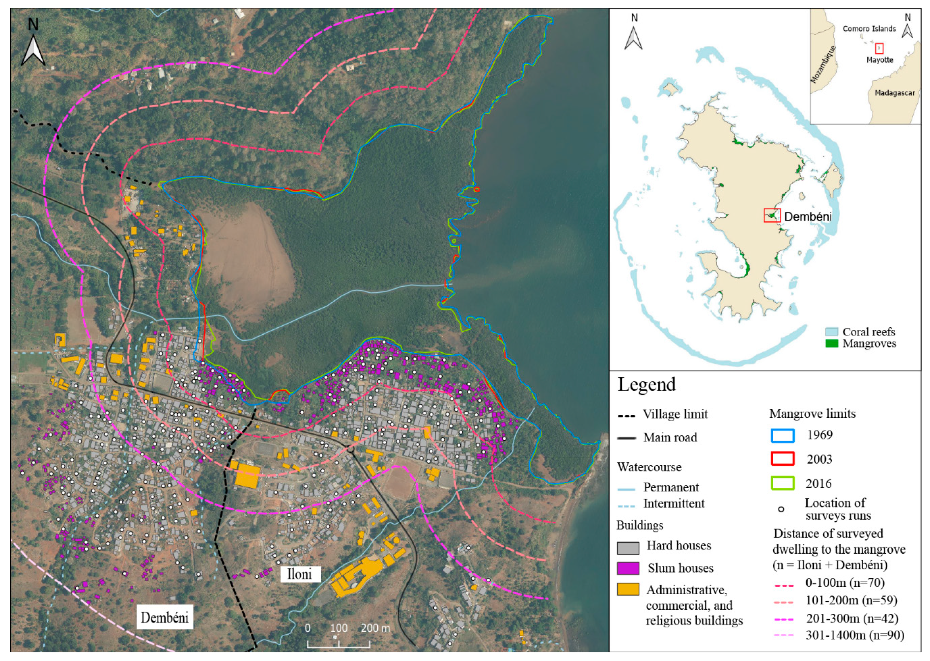
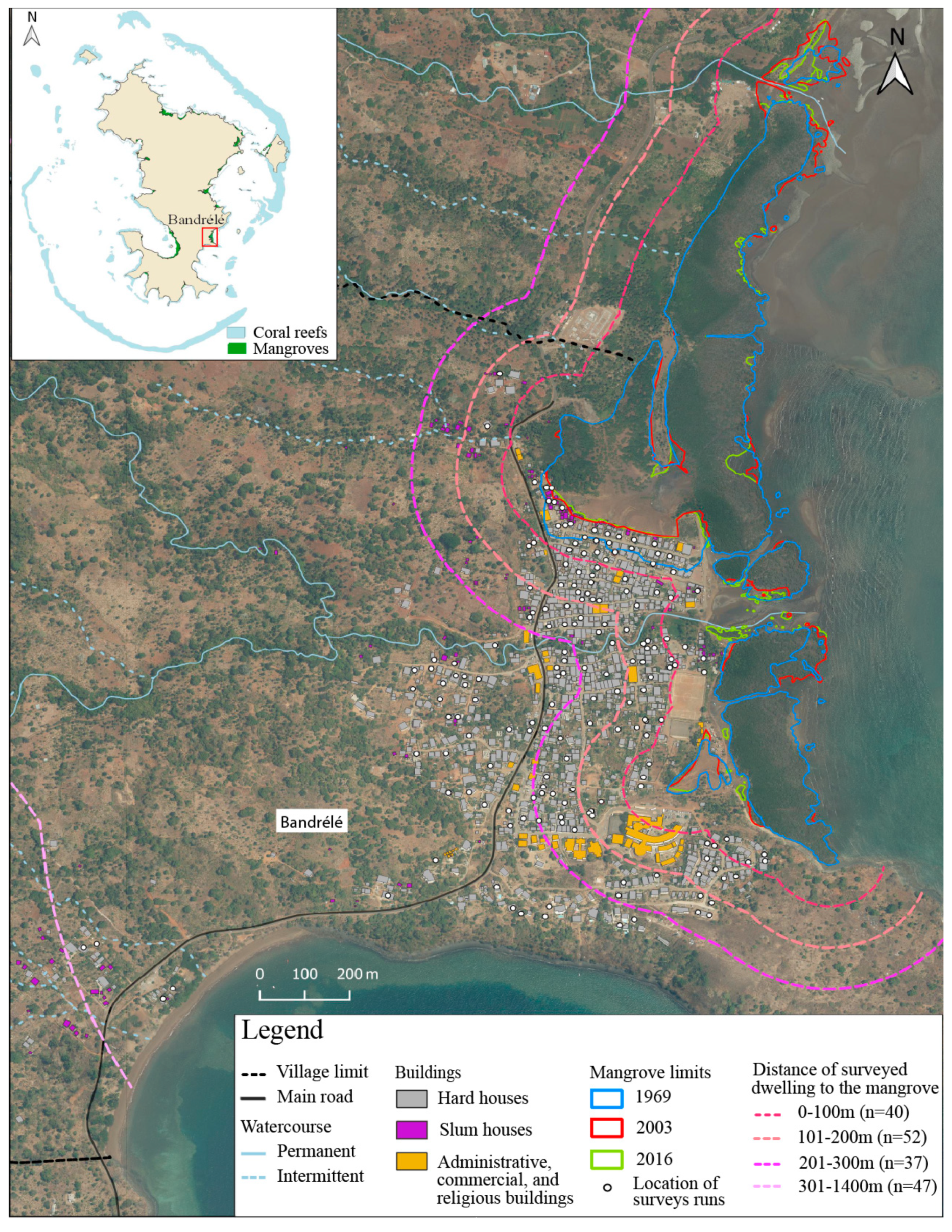
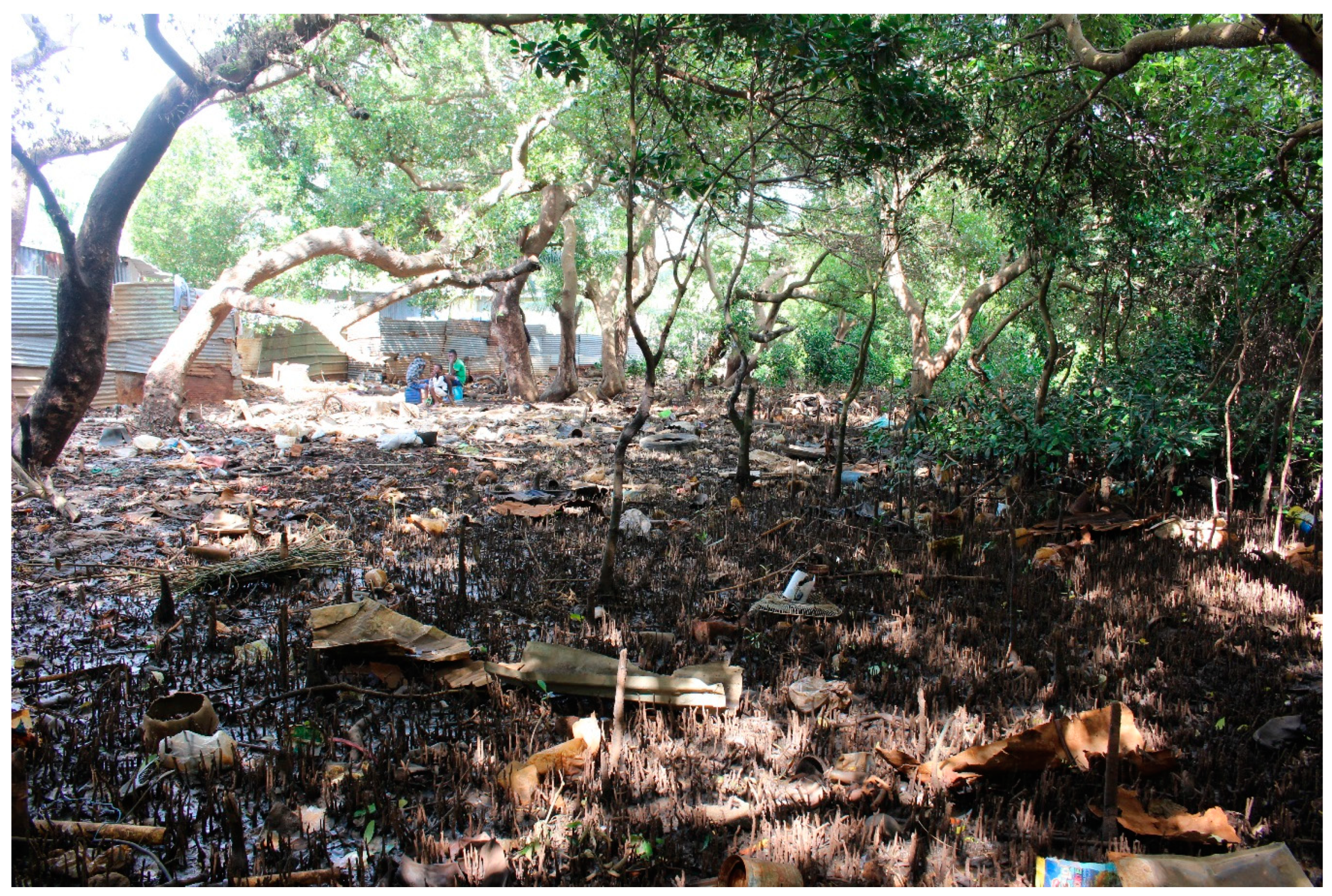
Table 1.
Knowledge on the name of mangrove tree species (n = 251).
| Type of Answer | Latin | French | Shimahore 1 | Kibushi 1 | Answer |
|---|---|---|---|---|---|
| Mangrove tree species | Avicennia marina (Forssk.) Vierh. | Palétuvier blanc | Musiri | Afi afi | 30.7% |
| Rhizophora mucronata Lam. | Palétuvier rouge | Muhoko bole | Honku ampira | 11.2% | |
| Ceriops tagal (Pers.) C.B.Rob. | Palétuvier jaune | Muhoko ndziche2 | Honku vavi | 6.4% | |
| Sonneratia alba Sm. | Palétuvier fleur | Muhoko ndziwi | Honku be | 3.6% | |
| Bruguiera gymnorhiza (L.) Lam. | Palétuvier gros poumon | Muhoko ndrume2 | Honku lahi | 3.2% | |
| Xylocarpus granatum K.D.Koenig | Palétuvier pomme | Mugodzo bole | Karudsi nanta lautsi be | 0.8% | |
| Lumnitzera racemosa Willd. | Palétuvier à petites fleurs | - | Honku tokana | 0.4% | |
| Back mangrove | Hibiscus tilicaceus L. | Hibiscus bord de mer | Mwaro, Haro ndzishe | Bwaro vavi | 1.6% |
| Erythrina fusca Lour. | Erythrine | Mwinga, munungu | Mwinga vavi | 0.4% | |
| Heritiera littoralis Aiton | Bois de table | Mukumafi | Murumuni | 0.4% | |
| Description of the tree (e.g., the black mangrove tree, the mangrove tree with seeds, the mangrove tree with stems falling down) | 3.6% | ||||
| Other (mango tree, apple tree, names in local language with meanings not found) | 2.4% | ||||
| I do not know | 61.4% | ||||
1 Completed or corrected by the nomenclature given by [48,49,50]. In Mayotte, mangroves are called muhonko or muhoko, as in the studied villages. 2 We followed Amann et al. [48] but in Barthelat [50], Muhoko ndziche is the local name for Bruguiera gymnorhiza and Muhoko ndrume for Ceriops tagal. Future studies on mangroves in Mayotte should take into account it is not known whether one source is mistaken or if local people, perhaps depending on the village, use either local names interchangeably.
Table 2.
Criteria mentioned by surveyed people to justify the health state of the mangrove of their village.
Table 2.
Criteria mentioned by surveyed people to justify the health state of the mangrove of their village.
| Criteria for Health State of Mangrove | Good State | Partially Degraded | Bad State | |||
|---|---|---|---|---|---|---|
| Today | 10–20 Years ago | Today | 10–20 Years ago | Today | 10–20 Years ago | |
| Surface | 23.4% | 30.1% | 12.0% | 16.7% | 9.6% | 0.0% |
| Density | 42.2% | 26.1% | 6.6% | 13.3% | 3.7% | 0.0% |
| Young tree | 9.4% | 4.5% | 0.6% | 3.3% | 0.0% | 0.0% |
| Mortality | 3.1% | 2.8% | 5.4% | 6.7% | 4.4% | 0.0% |
| Waste | 14.1% | 32.4% | 65.7% | 43.3% | 71.1% | 75.0% |
| Polluted water | 1.6% | 1.1% | 4.2% | 0.0% | 11.1% | 0.0% |
| Tree cutting | 10.9% | 17.0% | 27.1% | 43.3% | 37.8% | 50.0% |
| Management | 14.1% | 7.4% | 6.0% | 6.7% | 8.9% | 25.0% |
| Constructions (dwelling, embankments) | 1.6% | 15.9% | 12.0% | 10.0% | 37.0% | 12.5% |
| Other | 21.9% | 13.6% | 8.4% | 10.0% | 8.9% | 0.0% |
| Number of answers | 91 | 266 | 246 | 46 | 260 | 13 |
| Number of respondents | 64 | 176 | 166 | 30 | 135 | 8 |
Mangrove state today: on average, 1.6 ± 0.8 answer. Mangrove state 10 to 20 years ago: on average, 1.5 ± 0.7 answer.
Table 3.
Factors influencing significantly the local ecological knowledge (LEK) of respondents.
| Knowledge Category | LEK | Village | Gender | Age Class | Education Level | Residence Time | Childhood Location | Mangrove Since Childhood | Penetrating Mangrove | Harvesting Practice | Nature Walk | Attachment | Dwelling Distance to Mangrove |
|---|---|---|---|---|---|---|---|---|---|---|---|---|---|
| Absolute knowledge | Type of ecosystem (sea, land, intertidal) | <0.1 | - | 0.02 | <0.01 | 0.02 | - | - | - | - | - | - | - |
| Difference between mangrove trees and other trees | <0.01 | <0.01 | - | 0.04 | <0.01 | <0.01 | <0.01 | <0.01 | 0.02 | <0.01 | <0.01 | 0.02 | |
| Number of mangrove tree species | <0.01 | <0.01 | <0.01 | <0.01 | <0.01 | <0.01 | <0.01 | <0.01 | <0.01 | <0.01 | <0.01 | - | |
| Knows whether mangrove provide services | - | 0.01 | 0.02 | - | - | - | - | - | - | 0.04 | <0.01 | - | |
| Relative knowledge | Mangrove state today | <0.01 | <0.01 | - | 0.03 | <0.01 | <0.01 | <0.01 | <0.01 | - | <0.01 | <0.01 | - |
| Mangrove state 10–20 years ago 1 | - | - | - | - | 2 | 2 | 0.01 | - | <0.01 | - | <0.01 | - | |
| Surface evolution of mangrove 1 | <0.01 | - | - | - | 2 | 2 | - | - | 0.2 | 0.04 | <0.01 | - |
1 The number of respondents is lower than for the first five variables (Supplementary Table S1). 2 The cross tabulation could not be performed for these variables because of residence time of respondents leading to empty columns.
Publisher’s Note: MDPI stays neutral with regard to jurisdictional claims in published maps and institutional affiliations. |
© 2021 by the authors. Licensee MDPI, Basel, Switzerland. This article is an open access article distributed under the terms and conditions of the Creative Commons Attribution (CC BY) license (http://creativecommons.org/licenses/by/4.0/).
Share and Cite
MDPI and ACS Style
Longépée, E.; Ahmed Abdallah, A.; Jeanson, M.; Golléty, C. Local Ecological Knowledge on Mangroves in Mayotte Island (Indian Ocean) and Influencing Factors. Forests 2021, 12, 53. https://doi.org/10.3390/f12010053
AMA Style
Longépée E, Ahmed Abdallah A, Jeanson M, Golléty C. Local Ecological Knowledge on Mangroves in Mayotte Island (Indian Ocean) and Influencing Factors. Forests. 2021; 12(1):53. https://doi.org/10.3390/f12010053
Chicago/Turabian StyleLongépée, Esméralda, Anliati Ahmed Abdallah, Matthieu Jeanson, and Claire Golléty. 2021. "Local Ecological Knowledge on Mangroves in Mayotte Island (Indian Ocean) and Influencing Factors" Forests 12, no. 1: 53. https://doi.org/10.3390/f12010053
Note that from the first issue of 2016, this journal uses article numbers instead of page numbers. See further details here.