


1. Introduction
The International Antarctic Glaciological Project (I.A.G.P.) aims to understand the present ice sheet around the Wilkes Land region of East Antarctica and to determine its past history along with that of its environment, most particularly the climate, cf, Reference RadokRadok (1977), and anonymous (1971). The data source for the past history is to be obtained from deep core-drilling studies. The stable-isotope ratio of the ice is understood to provide information on the temperature and place of origin of the ice, and the entrapped gas content (per unit mass of ice) can be interpreted in terms of the temperature and elevation of origin of the ice. Thus in order to interpret the past history in terms of deviations from the present, an analysis of the flow of the ice must be carried out to determine the place of origin of the ice. The deviations are then obtained as differences from the present properties as measured along the surface of the ice sheet at the sites of origin, of the ice in the core.

Fig. 1. Map of the region of Antarctica between Dumont d’Urville and Dome “C” showing the elevation contours (m), the general flow directions (long dashed lines), the accumulation-rate (short dashed line, kg m-2 a-1), and the traverse route towards Dome “C” from D to, extended (dotted line) to the end points for the flow-line calculations.
The most convenient sites for drilling to determine the past history arc clearly dome summits where effects of horizontal ice morion are minimal. Nevertheless the change of elevation and possible migration of summits and local overriding need still to be kept in mind.
To determine the past changes of the ice sheet, further core studies are needed along a flow line of the ice sheet to the coast, where the elevation changes can be expected to be largest. To interpret coastal ice cores, data must be obtained on the present ice sheet properties along the flow line up-stream from the core.
Several cores have been obtained from the coast in Terre Adélie, the last being at D 10, about 5 km inland, where a 303 m core from the surface to the bed was obtained in 1974 (Reference Lorius and MerlivatLorius and Merlivat 1977). Data were collected on a traverse approximately along the general flow direction up-stream from D 10 towards Dome “ C “ (about lat. 740 39 S., long. 1240 10’ E.) in 1971-72. Detailed surface studies were made at Dome “ G “ in 1974-75, and an ice core was obtained to 905 m depth at Dome “C“ in January 1978.
This paper represents a tentative interpretation of the past changes of the ice sheet and climate by a detailed analysis of the coastal core data in comparison with profiles derived from the flow-line data, assuming a steady-state flow under the present regime.
2. Traverse Observations
The traverse route from Terre Adélie towards Dome “G“ is shown in Figure 1, Data collected en route include: surface elevation, chemical and isotopic content of surface snow, accumulation-rates from measurements on stakes and ^-activity of cores, and temperatures at 10 m depth in the firn. Some results of this work have already been presented by Reference Lorius and MerlivatLorius and Merlivat (1977), Reference Boutron and LoriusBoutron and Lorius (1977), Reference Merlivat, Merlivat, Jouzel, Robert and LoriusMerlivat and others (1977), and Reference Lambert, Lambert, Ardouin, Sanak, Lorius and PourchetLambert and others (1977).
Ice thickness has been determined in the coastal region by seismic and gravity means. A profile of the surface and bed is given by Reference Lorius and MerlivatLorius and Merlivat (1977). Gravity measurements were also taken along the traverse but the ice-thickness data used here have been obtained primarily from the aerial radio echo-sounding programme being carried out by the Scott Polar Research Institute, U.K., and the Division of Polar Programs of the U.S. National Science Foundation (cf Reference Robin and deRobin, 1975; and Reference RobinRobinand others, 1977). Large-scale surface elevation, ice thickness, and bedrock elevation have been presented by Reference DrewryDrewry (1975)) and a detailed profile along the traverse line from Terre Adélie to Dome “C“ is given by Steed and Drewry (in press).
This covers the basic data required for the modelling discussed below, except for velocities. The velocity at D 10 has been measured by survey techniques to be c. 5.4 m a- 1 . The velocity at Dome “C“ is taken as zero. In between the velocities have been derived from “balance velocities” which have been calculated as average column velocities assuming a steady-state flux for the ice sheet with the present distribution of accumulation and ice thickness. The variation along the flow line of the basic data required for the modelling is shown in Figure 2.
3. Core Drilling Results From D 10
The most important properties for this study from the core drilling at D 10 are the profiles of ice-core isotope ratios, the ice-core gas content, and the bore-hole temperatures. These are shown in Figures 3 and 4. Isotopic and bore-hole temperature profiles are from Reference Lorius and MerlivatLorius and Merlivat (1977) and Reference Gillet, Gillet, Donnou and RicouGillet and others ([c 1976]) and the gas volume data arc discussed in Section 4.

Fig. 2. Flow-line data used for modelling. Tht values of the relative deuterium content (δD in ‰), surface mean temperature (θin ΰC), balance velocity (V in m a -1) and accumulation rate (A in kg m-2 a -1) art shown as a function of distance along the flow line to the coast (1 032 km) and for the enlarged section to 32 km inland. The different curves for accumulation rate and velocity correspond to the rallies used in the different runs for which the results are shown in Figure 6.
For the isotopic profile the present distribution of surface values along the traverse line, beyond the 1 000 m elevation point, can be used to determine an elevation scale to assist in the interpretation of the origin of the ice for steady-state conditions. It is clear from the isotopic profile that it does not represent a simple case of steady-state flow. A clue to the cause of the complication is provided by the presence of basal morainic-type ice in the core between the depths of 227 and 237 m. This was taken into account in the modelling as described below.
4. Gas Content and Isotope Variations with Depth along the D 10 Core
The total gas content (V, measured by volume at s.t.p.) of polar ice, when the firn pores close off definitively from the atmosphere, depends on the elevation, temperature, and pore volume at close-off (Ve) at the ice-formation site (Reference Raynaud and LoriusRaynaud and Lorius, 1973). Measurements of V on recent ice formed in a few known sites (Reference Budd and MorganBudd and Morgan, 1977; Reference RaynaudRaynaud and Lorius, 1977) suggested that V depends essentially on the elevation. Nevertheless this remained to be established for a wider range of temperature and elevation conditions. This has now been done, using in particular an ice core recently recovered from Dome “C“ (mean annual temperature —53.5°C, elevation 3200 m). The results, which will be published elsewhere (Raynaud and others, in press) indicate a decrease of V with elevation which corresponds to a linear decrease of Vc with temperature at a rate of about 7X 10⁻⁷ m3 deg-1 kg-1. Under present Antarctic surface conditions, an elevation increase of I 000 m corresponds to a decrease in V of about 15%, the temperature parameter being responsible for less than one-tenth of the observed change. These figures clearly show that V depends primarily on the elevation and secondarily on the temperature.

Fig. 3. Data from D 10 ice core and bore hole as a function of depth.
(a) Deuterium isotope ratios (δD), relative to SMOW.
(b) Entrapped air content, in volume (V) of gas at s.t.p. per gramme of ice, smoothed from mean V values (x) obtained for each depth level.
A first set of measurements of V along the D 10 core has already been described (Reference Raynaud and LoriusRaynaud and Lorius, 1977). The gas was extracted by fusion of the ice under vacuum, the water vapour being trapped and the dry gas collected by a Toepler pump in a gas burette. Three years later we remeasured the same profile using a similar method except that the extraction was carried out by melting and refreezing the ice under vacuum. This second set of measurements, which involves more than 100 V determinations representative of 20 depth levels between 54 and 247 m depth, is generally in very good agreement with the first set and is shown in Figure 3. These new V determinations enable us to describe more accurately the variations of V with depth. The lower part of the core, below 247 m depth, is badly cracked and is consequently not representative of its initial gas content. As pointed out by Reference RaynaudRaynaud (1977), the short-term variations of V observed between different ice samples formed at the same site necessitate the use of mean V variations to determine the elevation change of the formation site. The smoothed V variations calculated from the second set of measurements at D 10 are shown in Figure 3. The V increase observed in the upper part of the profile down to about 130 m depth is probably linked to the proximity of the close-off level (the ice sample being under vacuum prior to the gas extraction, part of the gas is lost if the pore close-off is still fragile) and consequently not representative of the elevation of the formation site. The general trends of the smoothed V variations below 130 m depth are:

Fig. 4. The measured temperature-depth profile (full heavy line) it shown together with calculated curves from different flow-line runs showing that it is possible to match the measured curve, below 60 m, closely by an appropriate choice of the bast gradient (yo in deg/102 m). The shorter profile (3} corresponds to a run with the higher base for the velocity profile.
-
(1) An irregular V decrease of about 24% between 130 and 205 m, this decrease being particularly pronounced from approximately 190 m.
-
(2) An almost constant mean value below 205 m.
The mean stable-isotope content (δ l8 0or SD) of cold ice can be considered as an indication of the mean temperature of the snow deposit site and consequently the 8 variations along polar cores reflect changes in the snow deposit site (Reference Budd and MorganBudd and Morgan, 1977; Reference Lorius and MerlivatLorius and Merlivat, 1977), as well as variations in the climatic conditions prevailing at this site (see for instance Reference Dansgaard, Dansgaard, Johnsen, Clausen and GundestrupDansgaard and others, 1973). The deuterium profile measured along the D 10 core has been published and discussed previously (Reference Lorius and MerlivatLorius and Merlivat, 1977). In this paper mean values over 5 m intervals have been used (Fig, 3). As shown by Figure 3, the mean V and 8 variations with depth indicate similar general trends. Nevertheless a clear difference in depth appears between the rapid δ decrease observed near 210 m and the marked V decrease which occurs in the 195-200 m range.
5. Modelling of the Flow Line to D 10
Generalized flow lines were constructed as orthogonals to the elevation contours as shown in Figure 1. These were then used together with the accumulation-rates and ice thickness to derive average column velocities required to maintain steady state, as described by Reference Budd, Budd, Jenssen and RadokBudd and others (1971). These velocities were used for the modelling until a maximum of 53 m a~’ was reached, inland of the outlet basins of the coastal glaciers. From there the velocities were taken to decrease smoothly to the measured velocity at D 10 of 5.4 m a-1. This reduction in speed is associated with the strong divergence of flow into the outlet glaciers.
The model used is similar to that described by Reference Budd, Budd, Jenssen and RadokBudd and others (1971), with some more recent modifications, as given by Reference Budd, Budd, Young and AustinBudd and others (1976). Briefly, the data for surface and bedrock elevation, accumulation-rate, average horizontal velocity, and surface temperature along the flow line arc fed into the model. Additional information needed to be prescribed includes the basal geothermal gradient and the thermal properties of the ice. A hypothetical column is followed outwards to the coast, and particle paths, ages, and temperature profiles are calculated. Ice-flow properties can also be prescribed, and “dynamics velocities” calculated, from the shear stress and derived temperatures using prescribed flow-law parameters. Additional features calculated include basal melt (or growth) rates, elevation of origin of the ice, isotope profiles, dielectric properties, etc.

Fig. 5. The flow-line results are shown with the surface and bedrock profiles, including: particle paths (full lines), ages (dashed lutes, 103 a), and temperature profiles. The base below melting is shown hatched and melting by the open double lines with the zone in between at pressure-melting point but not melting. Surface and hast temperatures are indicated in ΰC. The section from i ooo km to D 10 (/ 028 km) is shown on an enlarged scale.
The major results for the flow line as a whole are illustrated by Figure 5. The ages tend to be greater, and the temperatures higher, than those obtained in the earlier study by Reference Budd, Budd, Jenssen and RadokBudd and others (1971). This is mainly due to the lower accumulation-rates and lower bedrock used in this study, as obtained from the more recent field work.
There is a considerable problem in obtaining precise results for the D 10 location, because of its small local scale, in comparison with the whole flow line. Near the coast there is high variability in the flow regime associated with bedrock variations which become more important for the thinner ice. To obtain sufficient detail in the local area of D 10, grid-point spacing was chosen at 3 km intervals up-stream to 8 km then 5 km intervals to 28 km, 25 km intervals to 78 km, after which 50 km intervals were used to Dome “C”.
A further complication exists in that the coastal accumulation rates have high gradients and are very variable. The longer term accumulation from -activity is probably more reliable but docs not have as detailed a coverage. In order to examine the effects of possible errors in the estimates of accumulation-rate, several different calculations were carried out with different smoothed profiles for accumulation in the coastal region—using different weighting also on the )8-derived data.
Finally because of the unknown basal flow regime, which may have caused the morainic layer, near the 230 m depth, at D io, several different calculations were carried out with the velocity decreasing to zero at different depths, from 230 m Jo the base.
These changes to the input have little effect on the large-scale features of ages or trajectories shown in Figure 5 but they greatly affect the results at D 10. Consequently the ages and elevation of origin profiles are shown for the different runs at D 10 in Figure 6.
The implications of these results in relation to the derived age scales are discussed below.

Fig. 6. D to core; elevation of origin, and ages, as a function of depth as obtained for the different flow-line modelling runs, using the accumulation and velocities as shown in Figure 2 marked with the corresponding numbers, and for the base of the velocity profile at the bed (a) and higher up (b). The elevations of origin derived from the measured I values in the core and along the ice-sheet surface are shown as dash marks with length indicating the possible uncertainty (3}. The ages (in 103 a) at vomits depths fir each profile are marked with corresponding symbols.
6. An Analysis of the D 10 Temperature Profile
The main unknown factor required for the modelling of the ice-sheet temperatures here is the geothermal temperature gradient. The measured basal gradient can be affected by past climatic and ice-sheet changes along with heat transfer with the bedrock. Here there has been no attempt to model effects of such past changes at this stage in order first to see how closely the measured profile can be matched by steady-state conditions. Hence the base gradient has been varied to give agreement with the measured gradient taking account of internal frictional heating as described by Reference Radok, Radok, Jenssen and BuddRadok and others (1970). The implied geothermal gradient is then derived as a result.
For the other fixed boundary condition,, the temperature at 60 m depth has been chosen since the upper surface temperatures are greatly affected by recent short-term temperature fluctuations.
Some resultant temperature profiles obtained from the flow-line calculations described above are shown in Figure 4 in comparison with the measured profile. It is clear (hat the profile below 60 m depth can be matched very well by the model. A geothermal gradient of between 2.8 and 3,3 deg/102 rn is applied, depending on the particular accumulation-rate used.
The deviation in temperature above the 60 m depth suggests that there has been a recent warming of the order of 1 to a deg over a period of the last few decades or century. Similar warming has been observed in other bore holes in Antarctica (cf. e.g. Reference Budd, Budd, Young and AustinBudd and others, 1976). It is of interest to note that a similar warming effect could be discernible in the upper layers of the profile of isotopic ratios above the 25 m depth.
7. Computed Origin and Age Profiles
The results of the calculated ages and elevations of origin as described in Section 5 are shown in Figure 6 together with the results obtained from the isotopes in the ice core and along the present ice-sheet surface.
First of all, if the base for the velocity profile is taken at the bedrock, then the measured isotopic profile is only well matched down to about 200 m depth with the lower accumulation-rates. The ages in this case give the rapid change of isotopes from the 217 m to 200 m depths as being from 6 000 to 4 000 B.P.
On the other hand if the base is taken at the level of the morainic ice, the match, down to the same depth, is achieved for an intermediate accumulation-rate as shown by model run 4. In this case the large change in isotopes occurs from about 10 000 to 6 000 B.P.
Below approximately 200 m depth a match is never obtained indicating departure from steady-state conditions. As pointed out above, there is a considerable problem in obtaining precise results for the D 10 site from modelling the ice flow, We now propose another way of considering further past departures from steady-state conditions.
8. Change in Climate and Ice-Sheet Elevation from the D 10 Ice Core
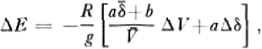
Since V and δ depend in particular on the elevation of the site of ice formation or snow deposit and on the temperature conditions, and, since generally the conditions prevailing at both sites are very close, it has been possible to propose a theoretical model (Jenssen, in press) which enables us to calculate the changes in the formation-site elevation ΔE, and the climatic fluctuations in terms of temperature ΔT, from the variations of V and δ observed along the polar cores, considered as time records.
ΔE and ΔT between two different depth levels of a core are given by:
and
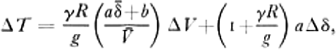
where 5 and V are the isotopic and gas contents averaged over the two levels, Δδ and ΔV their changes between the two levels, R the dry-air specific constant, g the acceleration due to gravity, γ the temperature-elevation lapse-rate. This model is based on several hypotheses detailed by Jenssen (in press) and Reference RaynaudRaynaud (1977). In particular, it has been established considering a linear relationship (T = aδ+b) between temperature and isotopic composition and a constant close-off porosity. To take into account the variation of the pore volume at close-off with temperature revealed by the Dome “ C “ results we have modified Jenssen’s model (Raynaud and others, in press). 7 and δ variations along the D 10 core, as plotted on Figure 3, have thus been processed to determine the elevation changes of the formation site and the climatic component of the 8 variations. The calculation has been made taking into account the relationship between SD in parts per thousand and T in degrees of the form δD = 6.04T-51 deduced from the present 5 variations with the mean temperature, at the surface along the presumed flow line, for a temperature range from —20 to — 55ΰC (Reference Lorius and MerlivatLorius and Merlivat, 1977). We assume that this relationship does not change with time, as suggested by Reference RobinRobin (1977).
The results of the calculation for elevations of origin and climatic changes are shown in Figure 7, in which elevations from the steady-state ice-flow model run 4 have also been plotted.
9. Discussion
We will restrict our discussion to the ice above about the 250 m depth. Further down there are no gas data and the steady-state ice-flow model does not apply. This makes the interpretation of the δ profile in the lowest levels difficult and this has been discussed elsewhere (Reference Lorius and MerlivatLorius and Merlivat, 1977).
From the surface down to about 200 m there is a rather good overall agreement between elevations of origin (Fig, 7a) from the steady-state ice-flow model run 4 (curve 1), the V and 8 calculations (curve 2), and the isotopes (curve 3). Below 200 m there arc large differences between the three curves indicating departure from steady-state conditions.
Since the gas inclusions do not move appreciably with respect to the ice matrix (Reference RaynaudRaynaud, 1977) the differences between curves 2 and 3 can be attributed to a marked difference between the location where snow is deposited and ice-formation sites and/or a climatic change.
Figure 7b, curve 1, shows climatic changes calculated from the V and δ measurements along the core. Although there are many limitations in this calculation, the most striking feature is the very abrupt change towards a much colder climate below 200 m for ice older than about 8 000 years according to the ice-flow model. The calculated isotopic shift (115‰ in SD) associated with this climatic change is much larger than the 40-50‰ shifts in δD which have been effectively recorded in central East Antarctic ice cores at about the same time at Vostok (Reference Barkov, Barkov, Korotkevich, Gordiyenko and KotlyakovBarkov and others, 1977) and at Dome “ C “ (Lorius and others, in press); it may however be worthwhile to mention that the calculated climatic part of the isotopic shift is only 75‰ in δD when compared to the mean climate for the ice above 190 m.
Furthermore a significant difference in the age and location of the snow-deposit and ice-formation sites can lead to erroneous calculations when using the V—8 model. A tentative calculation made by adjusting the depths corresponding to the marked V and δ changes at 195 m gives a climatic shift of about 75-80‰. This figure is still higher than the Vostok and Dome “ C “ results which could indicate the limitations of such calculations made, in particular, by using smoothed V variations derived from possibly over-spaced measurements.
A more reliable estimation may actually be obtained from the lower part of the V and 8 profiles, where both show more constant values. The calculated elevation is of the order of 2 500 m for an isotopic content of —355‰. Since the present isotopic composition of the surface snow at this elevation is about —300‰ (Reference Lorius and MerlivatLorius and Merlivat, 1977) this suggests an isotopic climatic change of 55‰ in SD, which agrees quite well with the Vostok and Dome “C” results.

Fig. 7. Derived temperature and elevation changes from the D io core.
(a) The smoothed elevation changes of the ice-formation site, as deduced from V and δ variations (2) and mean “isotopic” elevations (3), art shown as a function of depth together with the steady-state flow-tine results from model 4, (1),
(b) Smoothed changes in climate calculated from V and δ variations relative to the 130 m depth level and expressed in ΰC and ‰ of δD are shown as curve (1) . Corrected changes for the difference between deposit and ice-formation sites are tentatively estimated, curve (2).
Comparison of elevation curves (Fig, 7a) for ice below the 200 m depth suggests that the ice sheet may have grown thicker during the cold period. The maximum difference of elevations between curve 2 (F-S) and the steady-state model is of the order of 400 m, which may reflect a change of the ice thickness of about the same amount at a site about 250 km from the coast. The slight decrease observed for the gas-derived elevations between the 205 and 235 m depths is supported by a non-scattered set of results. It would indicate a change of about 400 m for the thickness of the ice sheet while travelling from about 450 km to about 250 km from the coast over the period 20000 to 8 000 B.P. If the estimated ages are correct, the 400 m thinning would have happened in about 2 000 to 3 000 years, which is a fairly rapid change.
The phase lag between the major changes in the δ and V profiles could suggest that the time for maximum of cold preceded the time for maximum ice thickness, and the warming period preceded the ice thinning towards the present approximately steady state.
In conclusion it appears from the D 10 ice-core data together with the ice-flow modelling results that since about 5 000 B.P. the ice sheet has been close to balance. Further back there are indications of a colder climate and a thicker ice sheet. The present steady-state analysis does not give accurate results for the period of the large non-steady changes.
In order to model the past changes adequately additional data arc required from ice-core drilling at more representative sites further inland along the flow line.
Acknowledgements
We thank Mr M. Paillet for his important participation in the measurements of gas content. Field work was supported by Terres Australes et Antarctiques Franchises, Expeditions Polaires Francaises., and the U.S. National Science Foundation as a contribution to the International Antarctic Glaciological Project.
Discussion
R. M. KOERNER: YOU have no error bars on your diagram of gas content versus elevation. What resolution can you achieve in determining elevation changes from gas content variations?
C. LORIUS; There are several problems in evaluating this error; one of them is the existence of short-term variations. A sufficient number of measurements using the same techniques should give a resolution of the order of 100 m.
D. A. FISHER: MOW safe is it to assume the temperature/δ relationship has not changed with time?
LORIUS: I agree that this is a difficult problem, although there are some indications that it could be true (Robin, 1977). However this assumption is not central to our discussion and if it is not valid then our interpretation of the D 10 ice core is only slightly affected.
M. M. HERRON; DO you have gas compositions for the ice below 250 m?
LORIUS: Below about 250 m the quality of the cores prevented any measurements of total gas content. No attempt was made to look at the composition.


