


THE Laboratoire de Glaciologie of the CNRS cored the snow and firn near the summit of Mont Blanc (French Alps) in 1973 and 1974 for geochemical purposes. This difficult task was performed under a contract from the Ministère de l'Environnement. As part of the programme, density and temperature profiles were measured at altitudes not studied since the time of Joseph Vallot.
In 1973, C. Boutron, Y. Morin, M. Paillet, and M. Pourchet stayed from 15 to 25 June on the site, lodging in the chilly aluminium Vallot hut (4 362 m) of the Club Alpin Français. In 1974, Mme M. Briat, M. Creseveur, Y. Morin, and M. Paillet stayed from 13 to 21 June, lodging in the neighbouring Observatoire Vallot (c. 4 350 m), a timber hut as chilly as the former, but where they were not disturbed by alpinists (although, as in the previous year, they had to assist alpinists in distress). This Observatoire Vallot is a legacy which was transferred in 1974 from the Paris astronomical observatory to our laboratory. We therefore hope that our preliminary results will be checked and enlarged in the future.
In this paper, the few measurements of temperatures in glaciers of the Alps will be reviewed. The knowledge of temperatures is important for (1) assessment of the internal nourishment of the glaciers (Reference BazhevBazhev, 1973; Reference Lliboutry and EchevinLliboutry and Echevin, in press), (2) explanation of some prominent features such as bergsehrunds and their change with time, (3) choosing places without percolation where past pollution can be studied on cores, as currently done in the polar ice caps.
Temperatures At About 4800 m
In 1973 coring was done to a depth of 16.7 m about 1 70 m to the east from the summit of Mont Blanc (Fig. I). (It could not be done at the very summit, because the snow is compacted and spoilt by alpinists.) The altitude of the site is 4 785 m. 200 m further to the east the snow and ice cap end in an ice cliff overhanging the Glacier de la Brenva by 1 100 m.

Fig. 1. Mont Blanc area. Rock faces in grey, glaciers in white. The sites of the 1973-74 corings are plotted X.
Preliminary data from beta-radioactivity show that the 16.7 m correspond to 12 years of accumulation. The mean density is 0.545 g/cm3, which gives as accumulation 760 mm of water equivalent. The 1.40 m/year of snow found for this site may be compared with 0.46 m/ year of snow which was deposited between 21 June 1973 and 16 June 1974 at a stake on the south-west side. At the very summit, a hut erected by Jansen at the end of the last century sank at a rate of about 1 m/year. These differences are consistent with the prevailing western winds.
No sign of past melting was found. The snow has the same qualities and consistency as in the Antarctic at several hundred kilometres from the coast. The site is definitely in the dry snow zone (Reference MüllerMüller, 1962; Reference KotlyakovKotlyakov, 1968, p. 310), Reference ShumskiyShumskiy’s (1955, Part III, chapter 2) recrystallizalion zone.
The temperature was uniform and equal to — 20.2°C at depth. This value is inconsistent with the temperature measured in a horizontal tunnel dug 15 m under the summit (4 807 m) in 1891-92 by Reference VallotVallot (1893): —16.7°C.
This difference of — 3.5 deg at 15 m depth cannot be explained by a secular trend. The explanation may be that the site drilled in 1973 was abnormal. At 16.7 m depth the coring auger entered an internal crevasse. We assume that very cold air, filtering through the snow, was trapped in this crevasse during winter.
Temperatures At About 4250 m
The snow was cored to 24.5 m deep in June 1973 at 4 280 m, between Col du Dôme and Observatoire Vallot. This site is a windy pass, where only 41 cm of snow were deposited between 21 June 1973 and 16 June 1974.
A thick layer of regelation ice was found, which proves that, in a previous year, percolation happened at this site. The temperatures at 0.85, 3.45, 14.23 and 17.0 m depth were found to be respectively — 6.70, — 10.40, — 10.50 and — 1o.75
°C (±0.05 deg).
In August 1911, Reference VallotVallot (1913) dug a pit at the Col du Dôme (4 240 m according to Vallot, 4255 m according to recent surveys). The temperature was — 0.1°C at 1 m depth (the 1911 summer was exceptionally hot), went through a minimum, — 13.2°C at 10 m depth and was — 12.8°C at 15m depth, He did not find a single regelation layer.
The 15 m temperature at this site has thus risen (making a correction of 0.2 deg for the difference of elevation) 1.8 deg between 1911 and 1973. We cannot say whether it is the consequence of a rise in the mean annual temperature, or a consequence of the abnormal percolation which happened in recent times, or both.
Reference FisherFisher (1955) measured in 1954 the temperatures in a tunnel dug at 4 240 m, 120 m below the Silbersattel of Monte Rosa, horizontally from the surface to the rock. Near the rock the ice was at — 13-3°C and, since there is a rock face nearby, he assumed that this was the mean annual temperature. This is consistent with Vallot’s observation. In the same tunnel, at 30 m from the entrance, temperatures as high as — 4.4°C were found. They must have resulted from regelation of melt water (positive air temperatures, up to +5.5°C were recorded by Fisher), rather than from geothermal heat, as this author thought.
We may tentatively conclude that in 1911 the altitude of 4 240 m was still in Shumskiy’s recrystallization-regelation zone, where some melting happens, but there is not enough melt water to migrate downwards. In this case latent heat is stored in situ between summer and winter, and the 15 m deep temperature equals the mean air temperature. In 1955 and 1973, this altitude was in the cold infiltration zone, where melt water percolates. In this zone latent heat is transferred from a vanished superficial layer downwards, and thus the 15 m deep temperature is higher than the mean annual temperature.
Temperatures At 3960 m
In 1974 the snow was cored at 3 960 m on Grand Plateau. The accumulation there is not known. It may be very high, since winter avalanches or wind-blown snow may feed this site. This fact should afford abnormally low temperatures.
Density and temperature profiles are given on Figure 2. The temperature at depth in the snow is — 7.3°C, significantly warmer than the mean air temperature. Many layers of regelation ice were found. The site is definitely in the cold infiltration zone.
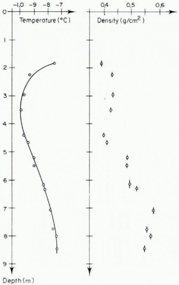
Fig. 2. Temperature alld dellsity profiles Oil Grand Plateau (3960 m) Oil 20 June 1974.
Temperatures At About 3540 m
On the upper plateau of the Vallée Blanche (about 3 540 m) near our “Refuge des Cosmiques”, several pits have been dug in May and June 1960, disclosing many ice layers, lenses, and pillars. Nevertheless most of them are formed in the snow layer which disappears during the ablation season. Only a few ice layers are found in the firn cores. The firn has been cored in 1963, 1966 and 1970, and the entire glacier in 1971 (Reference Vallon, Vallon, Petit and FabreVallon and others, 1976).
There are about 30 m of firn, overlaying 150 m of ice. The winter accumulation amounts to 6-8 m of snow, and the mean annual balance (1954-71) is 3 180±46 mm of water per year. Below 15 m, firn and ice are always at the melting point. The site is in the temperate infiltration zone, as are most of the névés of alpine glaciers. For instance on the Jungfraufirn, at 3 460 m, Reference Hughes and SeligmanHughes and Seligman (1939) found the firn temperate at depth.
Since the mean air temperature reaches 0°C at about 3 100-3 200 m, cold infiltration zones can be found down to this altitude near exposures of bare rock. The separation between the cold ice frozen to the rock and the temperate ice, which slides over its bed, creates the bergschrunds. Bergschrunds may be found as low as 3 150 m at the foot of the northern wall of Grandes Jorasses. Under Refuge des Cosmiques there is a bergschrund at 3 560 m.
Limit Between The Cold Infiltration Zone And The Temperate Infiltration Zone

Fig. 3. 15 m deep temperatures found by Vallot (1892-93, 1911) and Laboratoire de Glaciologie (1960-71, 1973, 1974) versus altitude. The horizontal line corresponds to the various temperatures measured by Reference FisherFisher (1955) on Monte Rosa at larger depths.
Far from rock faces, the beginning of temperate ice and sliding can either produce an ice cliff which ends a hanging glacier, or large and almost uninterrupted crevasses, which must be likened to bergschrunds. According to the data above mentioned, summarized in Figure 3, we must expect to find these features between 3 600 and 3 900 m. Of course the aspect of the site and the downward flow of cold ice can modify this altitude.
As a matter of fact large cracks are found at about 3 800 m on the northern face of Aiguille du Goûter, 3 750 m between Grand Plateau and Petit Plateau, 3 750 m on the northern face of Mont Blanc du Tacul. On the north of Mont Maudit there are ice cliffs at 3 700-3 800 m. So we suggest that 3 800 m is the mean altitude of the transition between cold and temperate glaciers. Not on Mont-Blanc, but in the same region, the ice caps of Aiguille Verte (4 122 m), of Cimes de Rochefort (4 015 m) and the northern slope of Aiguille d’Argentière (3 900 m) should be cold.
it would be worthwhile to study old photographs to see if these features have changed since the past century, testifying to a secular trend of climate. The appearance of the lower cores from Vallée Blanche have been explained by a raising of the position of the bergschrund about 120 years ago (Reference Vallon, Vallon, Petit and FabreVallon and others, 1976).
Cold Ice Near The Firn Line
In general at the end of the ablation season we find on alpine glaciers below the equilibrium line old firn from previous years during which the balance has been more favourable, and next old glacier ice. In the Mont Blanc area, superimposed ice was never observed. During our borings in the ablation zone we never found cold ice.
Nevertheless in other areas and early in the summer, extensive areas of superimposed ice may exist, for instance on Glacier de Saint-Sorlin (Grandes Rousses) between 2 700 and 2 800 m. This superimposed ice looks like that found on Arctic glaciers: very white, with tiny vertical holes everywhere, from which the formation of cryoconite holes starts. Ft indicates that in June melt water percolated to glacier ice which was cold. (Some superimposed ice may form in autumn near the firn line, in old soaked firn, but since the ice below was not cold, the appearance is quite different).
Superimposed ice from spring disappears during the ablation season. At Glacier de Saint-Sorlin cold ice has never been found in August. Nevertheless Reference DupuyDupuy’s (unpublished) measurements of the liquid-water content in ice, when corrected from a systematic error due to the stocking time, give o% of liquid water at 5.5 m deep. Had this glacier ice never been subjected to a cold wave, it would have contained at least 0.2% of liquid water.
Cold ice in the ablation zone has been found in drier regions of the Alps. H. C. Hoinkes (private communication in 1974) has measured the temperature of the ice of the Hintereisferner (Ötztal) down to 15 m deep, at 2 800 m, that is 100-200 m below the equilibrium line. It is at — 1°C to — 2°C; only the first metre rises to melting point in summer. The winter (October—April) precipitation at the measuring site is about 500 mm of equivalent water.
According to H. Röthlisberger (private communication in 1975), —2°C to — 3°C has been measured at 10 m depth near the edge of the Grubengletscher above Saas Balen (Wallis).
Outside the Alps, but still in a mountain glacier of middle latitudes (Athabasca Glacier, Canada), similar and more precise results have been published by Reference PatersonPaterson (1972).
When near the firn line the glacier thickness remains almost uniform, there is no motion of ice perpendicular to the bedrock, no convective cold transfer downwards. Cold penetrates downwards by thermal diffusion only. Owing to the liquid-water content of temperate ice, there must be a sharp freezing front at depth. The bottom layers of these glaciers should remain temperate.
Discussion
J. W. GLEN: YOU have shown how under the summit of Mont Blanc there are substantial areas of cold firn. Does this flow down at depth into the outflow glaciers, and specifically in the Glacier des Bossons?
L. LLIBOUTRY; Probably, Temperatures at depth have never been measured, [Note added in proof, October 1975: According to Y. Morin and L. Reynaud (private communication in 1975), the ice at the tip of the tongue of Glacier des Bossons, which comes from the very summit of Mont Blanc, differs in bubble content and grain size from the ice in the ablation zone of this glacier and other glaciers of the area. Nevertheless it has become temperate.]


